- Home
- :
- All Communities
- :
- Products
- :
- ArcGIS Spatial Analyst
- :
- ArcGIS Spatial Analyst Questions
- :
- Can't convert NoData to 0
- Subscribe to RSS Feed
- Mark Topic as New
- Mark Topic as Read
- Float this Topic for Current User
- Bookmark
- Subscribe
- Mute
- Printer Friendly Page
- Mark as New
- Bookmark
- Subscribe
- Mute
- Subscribe to RSS Feed
- Permalink
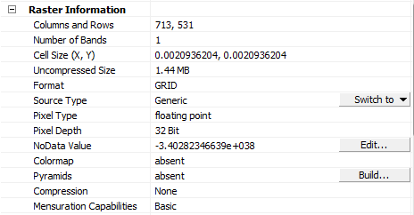
I have a NDVI image from MODIS product. Detailed information of this raster file is shown in the picture below.
I wanted to convert NoData (-3.4028234663e+038) value into 0 and keep other values unchanged. Then I used Con and IsNull statements on raster calculator. But it didn't work, the NoData value of output image is still the same with before it was. Here is the calculation: Con(IsNull("NDVI.tif"), 0, "NDVI.tif").
I used other ways to change NoData to 0 ie exporting the original raster file, using Set Null tool, changing data type. None of them worked.
Is there any other way to replace NoData values with 0?
Thank you so much for all comments in advance.
Solved! Go to Solution.
Accepted Solutions
- Mark as New
- Bookmark
- Subscribe
- Mute
- Subscribe to RSS Feed
- Permalink
or run the IsNull tool and if your output raster has any 0s it means that you have NoData.
- Mark as New
- Bookmark
- Subscribe
- Mute
- Subscribe to RSS Feed
- Permalink
is 0 a valid class? are there any nodata cells in the inputs? examine its histogram
- Mark as New
- Bookmark
- Subscribe
- Mute
- Subscribe to RSS Feed
- Permalink
or run the IsNull tool and if your output raster has any 0s it means that you have NoData.
- Mark as New
- Bookmark
- Subscribe
- Mute
- Subscribe to RSS Feed
- Permalink
The value in the properties is just the code used in that raster dataset for NoData cells (if any exist).
Because it is listed there does not mean you necessarily have any NoData cells.
- Mark as New
- Bookmark
- Subscribe
- Mute
- Subscribe to RSS Feed
- Permalink
I had the same experience, using the conditional function (Con(IsNull("NDVI.tif"), 0, "NDVI.tif"), doesn't help if there are no NoData values in your raster (which can be checked several ways). The problem here is simply the way NoData is defined in the raster properties of the file. If it is defined as '-3.4028234663e+038' this can indeed give execution problems in several operations further down the line (I suppose because this NoData value is read from the raster properties and used someway, somehow. However, an easy solution to this all is exporting your raster (right click -> Data / Export Data) and change the value of the field 'NoData as' to another value.
- Mark as New
- Bookmark
- Subscribe
- Mute
- Subscribe to RSS Feed
- Permalink
If [NoData] is defined as '-3.4028234663e+038' this can indeed give execution problems in several operations further down the line
Depending on your workflow and the raster formats you are using the defaults sometimes don't do what you need, so:
- The Copy Raster tool includes a NoData_value parameter.
- The NoData environment setting controls how NoData gets mapped in by most raster tools. (The help for a tool tells you which env settings are used by a particular tool.)