- Home
- :
- All Communities
- :
- Products
- :
- ArcGIS Spatial Analyst
- :
- ArcGIS Spatial Analyst Questions
- :
- Re: ArcMap Nibble Problem
- Subscribe to RSS Feed
- Mark Topic as New
- Mark Topic as Read
- Float this Topic for Current User
- Bookmark
- Subscribe
- Mute
- Printer Friendly Page
- Mark as New
- Bookmark
- Subscribe
- Mute
- Subscribe to RSS Feed
- Permalink
I'm trying to fill in the areas in the RunoffCoeffRaster with small regions of NoData that were converted to the value zero (0), which was done because the Nibble tool seems to not replace any NoData values of the input raster. I'm using the original RunoffCoeffRaster that contained the NoData gaps but renamed to NibbleMask as the Mask raster parameter. I'm expecting that the 0 cells in the RunoffCoeffRaster that line up with the NoData cells in the NibbleMask raster to be replaced with values from the nearest neighbor cells of the RunoffCoeffRaster. However, that is not the output i'm getting. Instead, see the NibbleOutput raster in this file geodatabase. I'm using ArcMap v10.7.1.
See attached NibbleTroubleshooting.gdb.zip file for the relevant rasters and a model showing what I'm doing. I've tried all combinations of the 2 checkbox parameters to see if I'm misunderstanding the documentation, but without success.
Thoughts?
Solved! Go to Solution.
Accepted Solutions
- Mark as New
- Bookmark
- Subscribe
- Mute
- Subscribe to RSS Feed
- Permalink
Hi Jamie.
It appears that with your data the and the default settings for the tool (Use NoData values parameter checked, Nibble NoData parameter unchecked), the actual cell values are coming out as-expected, but there seems to be an issue where they are not rendering properly.
A workaround I found is to run the Float tool on the output from the Nibble tool. The resulting output seems to render correctly.
Have a look at the following. The first image shows the input raster and the input mask raster.
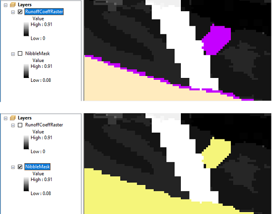
Note that I symbolized them a bit. In the Runoff input, I symbolized the cells of value 0 with purple, and the NoData cells with a light tan colour. In the Mask input, I symbolized the NoData cells to a light yellow colour.
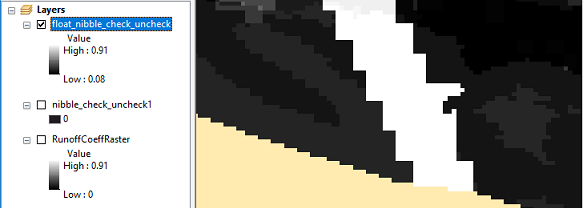
The next output shows the results. The "nibble_check_uncheck1" entry (not activated) is the output from the Nibble tool. It demonstrates the problem you report, where it looks like the output is all empty cells. The other result, "float_nibble_check_uncheck", is the outcome from running the Float tool on the output from the Nibble tool. The you should be able to see that the cells that you were looking to replace (the purple value = 0 cells from the input) have been.
This workaround seems to resolve the issue for the time being. I will take a closer look at the rendering problem, and will submit a software bug report accordingly. In the mean time, I hope that the workaround suggested will allow you to continue.
Thanks for reporting this.
Cheers,
Juan
- Mark as New
- Bookmark
- Subscribe
- Mute
- Subscribe to RSS Feed
- Permalink
Hello, Jamie.
I'm sorry you're having some trouble. Let's see if we can figure out the issue.
I downloaded the data you provided, but am not able to get it loaded into ArcMap successfully on my side. Would it be possible for you to re-upload it? Perhaps also convert your data to a separate folder as Tiff rasters before zipping them up, it might help avoid any geodatabase-related problems on the upload.
Thanks,
Juan Laguna
Spatial Analyst team,
Esri, Inc
- Mark as New
- Bookmark
- Subscribe
- Mute
- Subscribe to RSS Feed
- Permalink
Yes, I see what you mean. The copy/paste of the rasters from my Scratch.gdb to that empty NibbleTroubleshooting.gdb I created didn't work very well as I wasn't able to render them in a new MXD. So, I copied the Scratch.gdb, deleted everything else and loaded them into a fresh MXD to make sure they worked. I've included the Nibble Test model with the settings that I used and the NibbleOutput raster showing the same output I've been getting. I had tried extracting the rasters as TIF format, but ran into errors using the Export menu item from the Catalog view, as well as the Copy Raster geoprocessing tool. Keep getting 999999 error saying "No spatial reference exists" even though I see this set on the rasters (NAD_1983_Albers). If you know a better way, please advise! Thanks much!
- Mark as New
- Bookmark
- Subscribe
- Mute
- Subscribe to RSS Feed
- Permalink
OK, I was able to get the rasters extracted as separate TIF files from the NibbleTroubleshooting2.gbd I prepared and tested. Attaching now. When I run Nibble using these TIF file rasters, I still get the same result: an empty raster with only 0 on the legend.
- Mark as New
- Bookmark
- Subscribe
- Mute
- Subscribe to RSS Feed
- Permalink
Hi Jamie.
I am able to get to the data now, thanks!
I'll follow up once I've taken a look at it.
- Mark as New
- Bookmark
- Subscribe
- Mute
- Subscribe to RSS Feed
- Permalink
Hi Jamie.
It appears that with your data the and the default settings for the tool (Use NoData values parameter checked, Nibble NoData parameter unchecked), the actual cell values are coming out as-expected, but there seems to be an issue where they are not rendering properly.
A workaround I found is to run the Float tool on the output from the Nibble tool. The resulting output seems to render correctly.
Have a look at the following. The first image shows the input raster and the input mask raster.
Note that I symbolized them a bit. In the Runoff input, I symbolized the cells of value 0 with purple, and the NoData cells with a light tan colour. In the Mask input, I symbolized the NoData cells to a light yellow colour.
The next output shows the results. The "nibble_check_uncheck1" entry (not activated) is the output from the Nibble tool. It demonstrates the problem you report, where it looks like the output is all empty cells. The other result, "float_nibble_check_uncheck", is the outcome from running the Float tool on the output from the Nibble tool. The you should be able to see that the cells that you were looking to replace (the purple value = 0 cells from the input) have been.
This workaround seems to resolve the issue for the time being. I will take a closer look at the rendering problem, and will submit a software bug report accordingly. In the mean time, I hope that the workaround suggested will allow you to continue.
Thanks for reporting this.
Cheers,
Juan
- Mark as New
- Bookmark
- Subscribe
- Mute
- Subscribe to RSS Feed
- Permalink
Could the rendering issue be solved with calculate statistics?
- Mark as New
- Bookmark
- Subscribe
- Mute
- Subscribe to RSS Feed
- Permalink
Hi David,
Yes, that might be another way.
The output has the Unique Values renderer applied to it initially. If it is subsequently set to Stretched, the raster will then appear properly. Thanks for the additional suggestion. I'll incorporate it in the details when I make the submission.
Thanks,
Juan
- Mark as New
- Bookmark
- Subscribe
- Mute
- Subscribe to RSS Feed
- Permalink
Thanks Juan, I see the issue and that workaround works for me for now. I appreciate your prompt attention my issue. Take care!
- Mark as New
- Bookmark
- Subscribe
- Mute
- Subscribe to RSS Feed
- Permalink
Glad to help out, Jamie!