- Home
- :
- All Communities
- :
- Products
- :
- ArcGIS Solutions
- :
- ArcGIS Solutions Questions
- :
- Address Data Management Solution; Address Point vs...
- Subscribe to RSS Feed
- Mark Topic as New
- Mark Topic as Read
- Float this Topic for Current User
- Bookmark
- Subscribe
- Mute
- Printer Friendly Page
Address Data Management Solution; Address Point vs Site Address
- Mark as New
- Bookmark
- Subscribe
- Mute
- Subscribe to RSS Feed
- Permalink
ArcGIS Pro 2.5; latest edition of the Address Data Management Solution.
I'm trying to wrap my head around the need for both the Address Point Feature Class along with the Site Address Feature Class. From the data dictionary:
Address Point Feature class: [description] Address points represent the location along the street network where the specific site or service delivery address has been assigned.
Site Address Point Feature Class: [description] Site address points represent the location of site or service delivery addresses.
I'm primarily interested in the actual location of the address point. If it's 10 feet or 100 feet from the road, that doesn't matter to me; I want it as close to the primary structure as I can get it. Primary to me is defined as where humans either reside or congregate; homes, apartment buildings, condos, businesses. Of course there are exceptions to that definition like an elevated parking facility or if there is a need to address a barn, but you get the gist of where I'm coming from.
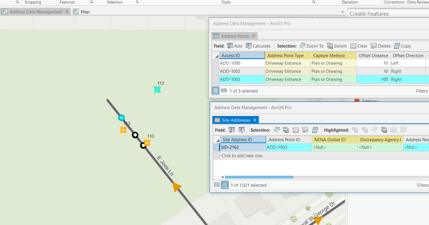
I notice in the sample data that the only Address Points are the ones I've just added. Going back to the data dictionary, there is a relationship class called Address Point Has Site Addresses and working through that relationship class, I can see which Site Address Point is associated with a given Address Point. ( See below). But I just don't see what value the Address Point FC brings to the process: please, enlighten me!
Edited to add: I notice that one cannot add a Site Address Point in and of itself; you need add an Address Point. So that's a function of the relationship class. But what happened to all the Address Points in the sample data?
Solved! Go to Solution.
Accepted Solutions
- Mark as New
- Bookmark
- Subscribe
- Mute
- Subscribe to RSS Feed
- Permalink
Hi Joe,
You don't have to use the address points. The address points help us provide an estimate of the address number of the site address point by calculating the percent along the road the address point is placed and the distance to offset the site address point from the road. If you would prefer to just place the site address points at the specific location and then populate the address number yourself you can ignore or remove the address points from the project.
You can create site address points without the address points by adding feature templates for the site address point layer. By default the project contains no feature templates for this layer. If you manage the templates in the map you should be able to add new feature templates for this layer so you can create the site address points without the need for the address points.
- Mark as New
- Bookmark
- Subscribe
- Mute
- Subscribe to RSS Feed
- Permalink
Awesome. Thanks Chris. I'm to a point where I'm going to add some of our address points into the site address points feature class. I'm sure to come up with some more questions as that progresses. Looking forward to our Skype meeting tomorrow.
- Mark as New
- Bookmark
- Subscribe
- Mute
- Subscribe to RSS Feed
- Permalink
Chris,
I've come to the conclusion that it may be easier to just recreate the functionality I like in the Address Management solution to work with our existing data. To start I would really like to figure out a way to alter the solution's address point and site address layers to work with our existing data and assign address numbers based on the rage attributes we have assigned in our own road centerline layer.
Is there any sort of guide that could assist with this process? What do you suggest I tackle first?
Screenshot of our StreetCenterline fields
