- Home
- :
- All Communities
- :
- User Groups
- :
- ArcGIS Server with JavaScript API
- :
- Questions
- :
- Creating a buffer
- Subscribe to RSS Feed
- Mark Topic as New
- Mark Topic as Read
- Float this Topic for Current User
- Bookmark
- Subscribe
- Mute
- Printer Friendly Page
Creating a buffer
- Mark as New
- Bookmark
- Subscribe
- Mute
- Subscribe to RSS Feed
- Permalink
Hello, this may be a basic question but I cannot resolve this issue.
I used an excel speadsheet populated with xy coordinates to plot points on my map and this worked out fine. I now want to place a buffer around the points and everytime I try I have gotten error messages saying "output feature class : <empty>" and "cannot open sheet1$events"
When I attempt to create the buffer I am pressing the dropdown arrow on input feature and selecting the layer I want, which then automatically populates the output feature class. I then put in the distance in and press ok.
What am I missing?
Thanks!
- Mark as New
- Bookmark
- Subscribe
- Mute
- Subscribe to RSS Feed
- Permalink
Try exporting as a shapefile or gdb feature class first!
- Mark as New
- Bookmark
- Subscribe
- Mute
- Subscribe to RSS Feed
- Permalink
As Chris mentioned, you will need to make is a shape or feature class. An event table is just a temporary view of the data.
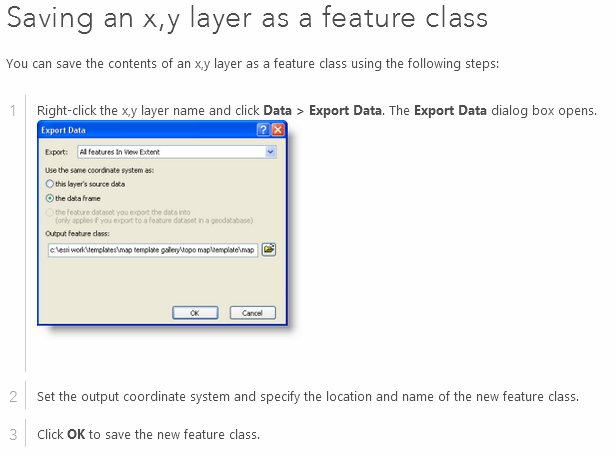
Adding x,y coordinate data as a layer—Help | ArcGIS for Desktop
...If you want to be able to perform these <<or pretty much any task..my comment>>tasks, you can export the x,y layer to a feature class using the steps below or follow the steps above to use the Catalog window to create a feature class from an x,y table....