Turn on suggestions
Auto-suggest helps you quickly narrow down your search results by suggesting possible matches as you type.
Cancel
- Home
- :
- All Communities
- :
- Developers
- :
- Native Maps SDKs
- :
- Runtime SDK WPF (Retired) Ques
- :
- Drawing a polygon using code.
Options
- Subscribe to RSS Feed
- Mark Topic as New
- Mark Topic as Read
- Float this Topic for Current User
- Bookmark
- Subscribe
- Mute
- Printer Friendly Page
Drawing a polygon using code.
Subscribe
05-23-2013
09:42 PM
- Mark as New
- Bookmark
- Subscribe
- Mute
- Subscribe to RSS Feed
- Permalink
Hi,
I am working on a requirement to have a region drawn on a graphics layer. This region should envelope a set of graphics already present. It can have two cases ->
1. Region might constitute a set of points (no. of points >4). How to draw a polygon in this case? The polygon as of I know takes 4 mappoints as argument.
2. Region might not have any points defined originally. How to draw a minimum area enveloping the set of graphics? Is there an inbuilt logic for the same?
Solved! Go to Solution.
1 Solution
Accepted Solutions
8 Replies
05-27-2013
01:14 AM
- Mark as New
- Bookmark
- Subscribe
- Mute
- Subscribe to RSS Feed
- Permalink
See sample from ArcGIS Runtime SDK for WPF -> Mapping -> Graphics Layers -> Add interactively / Add interactively Online. This should give you at least starting point.
05-27-2013
01:19 AM
- Mark as New
- Bookmark
- Subscribe
- Mute
- Subscribe to RSS Feed
- Permalink
Hi,
I have used the Draw class, and true is the best solution to draw anything using Interaction with map.
My requirement is however to be able to draw a region when I have , say a set of 7-8 Points. These regions should be visible on map once the map loads.
I have used the Draw class, and true is the best solution to draw anything using Interaction with map.
My requirement is however to be able to draw a region when I have , say a set of 7-8 Points. These regions should be visible on map once the map loads.
05-27-2013
02:25 AM
- Mark as New
- Bookmark
- Subscribe
- Mute
- Subscribe to RSS Feed
- Permalink
So you want to do something like this?
    <Window.Resources>
        <esri:SimpleRenderer x:Key="renderer">
            <esri:SimpleRenderer.Symbol>
                <esri:SimpleFillSymbol BorderBrush="Black" Fill="Red" BorderThickness="1"/>
            </esri:SimpleRenderer.Symbol>
        </esri:SimpleRenderer>


    </Window.Resources>
    <Grid>
        <esri:Map x:Name="_map">
           <esri:ArcGISTiledMapServiceLayer ID="Basemap"
                Url="http://services.arcgisonline.com/ArcGIS/rest/services/World_Topo_Map/MapServer"/>
            <esri:GraphicsLayer ID="Graphics"
                Renderer="{StaticResource renderer}"/>
        </esri:Map>
    </Grid>

public MainWindow()
        {
            InitializeComponent();


            var layer = _map.Layers["Graphics"] as GraphicsLayer;


            var polygon = new Polygon();
            var pointCollection = new PointCollection();
            pointCollection.Add(new MapPoint(-13446927, 6296089, new SpatialReference("102100")));
            pointCollection.Add(new MapPoint(-12564245, 6508379, new SpatialReference("102100")));
            pointCollection.Add(new MapPoint(-11882681, 6586592, new SpatialReference("102100")));
            pointCollection.Add(new MapPoint(-10810055, 5636871, new SpatialReference("102100")));
            pointCollection.Add(new MapPoint(-11178770, 4508379, new SpatialReference("102100")));
            pointCollection.Add(new MapPoint(-12173184, 4351955, new SpatialReference("102100")));
            pointCollection.Add(new MapPoint(-12877094, 4620111, new SpatialReference("102100")));
            // Closing point = same as first one.
            pointCollection.Add(new MapPoint(-13446927, 6296089, new SpatialReference("102100")));
            polygon.Rings.Add(pointCollection);
            polygon.SpatialReference = new SpatialReference("102100");


            var graphic = new Graphic() { Geometry = polygon };


            layer.Graphics.Add(graphic);
        }
}
05-27-2013
02:57 AM
- Mark as New
- Bookmark
- Subscribe
- Mute
- Subscribe to RSS Feed
- Permalink
Thanks 🙂 and yes I was looking for a response on same line.
This is actually what I tried in my application. And this seems to be the most common way to do it.
Next query is :
2. Region might not have any points defined originally. [Which means I donot have points to create Pointcollection).
How to draw a minimum area enveloping the set of graphics[say there are a number of Point geometries in an area] ? Is there an inbuilt logic for the same?
05-27-2013
09:33 PM
- Mark as New
- Bookmark
- Subscribe
- Mute
- Subscribe to RSS Feed
- Permalink
If I understood your need correctly, you can create polygon by using Convex Hull (http://resources.arcgis.com/en/help/runtime-wpf/apiref/index.html?esri.arcgis.client~esri.arcgis.cli...)
If you are using Standard version of the SDK, you can use local GeometryService and Convex Hull (See example Geometry -> Geometry operations -> Convex Hull) or if you are using basic you can use GeometryService provided by the ArcGIS Online or your own ArcGIS Server.
If you are using Standard version of the SDK, you can use local GeometryService and Convex Hull (See example Geometry -> Geometry operations -> Convex Hull) or if you are using basic you can use GeometryService provided by the ArcGIS Online or your own ArcGIS Server.
05-28-2013
01:36 AM
- Mark as New
- Bookmark
- Subscribe
- Mute
- Subscribe to RSS Feed
- Permalink
Thanks a ton!!
This is exactly what I am looking for.
Can we control the geometry that is generated. Right now it joins the points that are used to create the outer edge.
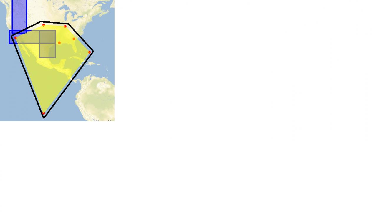
Please refer fig:
The yellow region is what the Convex Hull draws, and the black border would be what I am looking for. Can we provide some offset.
TIA.
This is exactly what I am looking for.
Can we control the geometry that is generated. Right now it joins the points that are used to create the outer edge.
Please refer fig:
The yellow region is what the Convex Hull draws, and the black border would be what I am looking for. Can we provide some offset.
TIA.
05-28-2013
01:43 AM
- Mark as New
- Bookmark
- Subscribe
- Mute
- Subscribe to RSS Feed
- Permalink
You can do about anything to that geometry. Like in this case, you could for example run it through Buffer. Refer sample Geometry -> Geometry Operations -> Buffer a Point.
05-28-2013
02:08 AM
- Mark as New
- Bookmark
- Subscribe
- Mute
- Subscribe to RSS Feed
- Permalink
Thanks!
that solves it :).
that solves it :).