- Home
- :
- All Communities
- :
- Developers
- :
- Native Maps SDKs
- :
- .NET Maps SDK Questions
- :
- Trying to map non spatial data from a database to ...
- Subscribe to RSS Feed
- Mark Topic as New
- Mark Topic as Read
- Float this Topic for Current User
- Bookmark
- Subscribe
- Mute
- Printer Friendly Page
Trying to map non spatial data from a database to a feature class
- Mark as New
- Bookmark
- Subscribe
- Mute
- Subscribe to RSS Feed
- Permalink
I'm currently using the ArcGis .NET runtime SDK 10.2.6. I've gotten my template mpk file loaded into the local server, and using the empty layers within that mpk I generate (spatial) data for a line on my map. I do this by adding the geometry and attributes to rows in the ServiceFeatureTable that I get from my local feature service (as an aside, why is there no "Truncate" or "Clear" on the ServiceFeatureTable? It's really awful trying to clean out that layer by deleting batches of IDs - You might want to add that functionality).
On to my question. I have this line, and now I have ancillary data that needs to be mapped on top of this line. This data is not spatial. It contains an ID that can be linked with the attribute data in the aforementioned line, and it has a begin and end measurement.
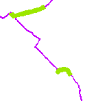
To give an idea of what I'm after, I have attached an image. The purple line is the spatial data that I've got from my database so far. The green is supposed to represent the non spatial data overlaid on top of the purple line (artist's rendition of that at least):
So, how do I do this using the runtime SDK? I'm guessing that I have to use a geoprocessing package or something along those lines?
I really don't want to have to do this by hand using a graphics layer, so any help would be appreciated.
Solved! Go to Solution.
Accepted Solutions
- Mark as New
- Bookmark
- Subscribe
- Mute
- Subscribe to RSS Feed
- Permalink
I managed to get this working (somewhat) via a model exported as a geoprocessing package.
However, I have additonal questions regarding the specifics of dealing with geoprocessing and SDE SQL/Oracle database connections. I've made a new discussion regarding this here: SDE Database connection in Runtime Geoprocessing Model