- Home
- :
- All Communities
- :
- Developers
- :
- Native Maps SDKs
- :
- .NET Maps SDK Questions
- :
- Can not load WFS-Featuretable from URL Hosted on M...
- Subscribe to RSS Feed
- Mark Topic as New
- Mark Topic as Read
- Float this Topic for Current User
- Bookmark
- Subscribe
- Mute
- Printer Friendly Page
Can not load WFS-Featuretable from URL Hosted on Mapserver
- Mark as New
- Bookmark
- Subscribe
- Mute
- Subscribe to RSS Feed
- Permalink
When I try to load a WfsFeatureTable from a WFS-Layer hosted on a MapServer, I get the following Error:
Invalid XML.: Parser couldn't move inside bounding box.
Is there any known issue with this topic in the arcgis runtime sdk for .NET 100.9?
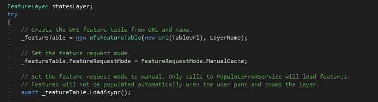
I tried to load this Layer with the SampleApplication ArcGISRuntime.WPF.Viewer.Samples.ChangeSublayerVisibility
I had no troubles with loading WFS-FeatureTable with other WFS-Layer for example hosted on a GeoServer.
When I try to connect to the MapServer WFS-Layer on QGIS, there is know problem with this
Solved! Go to Solution.
Accepted Solutions
- Mark as New
- Bookmark
- Subscribe
- Mute
- Subscribe to RSS Feed
- Permalink
I think I spotted the problem. Some of the layers in the capabilities document are missing information about geographic extent. These layers are:
- ms:aw_masslinien_punkte
- ms:aw_masslinien_linien
- ms:aw_masslinien_text
I see that MapServer actually generates a little warning comment on these layers, right in the XML:
<ows:WGS84BoundingBox/>
 <!--WARNING: Optional WGS84BoundingBox could not be established for this layer. Consider setting the EXTENT in the LAYER object, or wfs_extent metadata. Also check that your data exists in the DATA statement-->
Normally Runtime can handle layers without extent or geometry, but here MapServer does something not-by-the-specification. Instead of omitting WGS84BoundingBox completely, MapServer creates empty WGS84BoundingBox elements that lack required child elements. This causes the XML document to fail validation, and a loading error is reported by Runtime. I logged a bug with MapServer developers about this behavior. We will also look into broadening our XML parser's compatibility in future releases, to handle this edge-case and skip empty WGS84BoundingBox elements.
For now, I suggest trying MapServer's recommendation to ensure that all layers on the service have a geographic extent. Please let me know if this helps.
Cheers,
Matvei
- Mark as New
- Bookmark
- Subscribe
- Mute
- Subscribe to RSS Feed
- Permalink
Hello Daniel! I can think of a couple possible reasons for the service not working:
- Is WFS 2.0 enabled for this service? Runtime does not currently support the legacy WFS versions 1.0 or 1.1.
- Does the TableUrl point to the GetCapabilities endpoint of the service? For MapServer it should look something like this: http://your.domain.here/cgi-bin/mapserv?service=WFS&version=2.0.0&request=GetCapabilities (note "service", "version", and "request" parameters in the URL).
If you could share the URL of the service or a copy of the GetCapabilities response document, I would be happy to troubleshoot it further.
- Mark as New
- Bookmark
- Subscribe
- Mute
- Subscribe to RSS Feed
- Permalink
Hi Matvei
WFS 2.0 should be enable and the Table-URL looks like you described. Unfortunately I cannot share my URL to the public because the data of this Layer are protected, but I attached the GetCapabilities XML (URL is adjusted).
Let me know if you need further information.
Best regads,
Daniel
Von: Matvei Stefarov <geonet@esri.com>
Gesendet: Donnerstag, 8. Oktober 2020 18:56
An: Schuler Daniel <Daniel.Schuler@remec.ch>
Betreff: Re: - Re: Can not load WFS-Featuretable from URL Hosted on Mapserver
GeoNet, The Esri Community | GIS and Geospatial Professional Community <https://community.esri.com/?et=watches.email.thread>
Re: Can not load WFS-Featuretable from URL Hosted on Mapserver
reply from Matvei Stefarov<https://community.esri.com/people/MStefarov-esristaff?et=watches.email.thread> in ArcGIS Runtime SDK for .NET - View the full discussion<https://community.esri.com/message/957969-re-can-not-load-wfs-featuretable-from-url-hosted-on-mapserver?commentID=957969&et=watches.email.thread#comment-957969>
- Mark as New
- Bookmark
- Subscribe
- Mute
- Subscribe to RSS Feed
- Permalink
I think I spotted the problem. Some of the layers in the capabilities document are missing information about geographic extent. These layers are:
- ms:aw_masslinien_punkte
- ms:aw_masslinien_linien
- ms:aw_masslinien_text
I see that MapServer actually generates a little warning comment on these layers, right in the XML:
<ows:WGS84BoundingBox/>
 <!--WARNING: Optional WGS84BoundingBox could not be established for this layer. Consider setting the EXTENT in the LAYER object, or wfs_extent metadata. Also check that your data exists in the DATA statement-->
Normally Runtime can handle layers without extent or geometry, but here MapServer does something not-by-the-specification. Instead of omitting WGS84BoundingBox completely, MapServer creates empty WGS84BoundingBox elements that lack required child elements. This causes the XML document to fail validation, and a loading error is reported by Runtime. I logged a bug with MapServer developers about this behavior. We will also look into broadening our XML parser's compatibility in future releases, to handle this edge-case and skip empty WGS84BoundingBox elements.
For now, I suggest trying MapServer's recommendation to ensure that all layers on the service have a geographic extent. Please let me know if this helps.
Cheers,
Matvei
- Mark as New
- Bookmark
- Subscribe
- Mute
- Subscribe to RSS Feed
- Permalink
Hi Matvei
You were right. As soon as the extent were defined correctly, it worked! Thanks for your support.
Best Regards, Daniel