- Home
- :
- All Communities
- :
- Developers
- :
- Native Maps SDKs
- :
- Runtime SDK for iOS Questions
- :
- Layer has subtype?
- Subscribe to RSS Feed
- Mark Topic as New
- Mark Topic as Read
- Float this Topic for Current User
- Bookmark
- Subscribe
- Mute
- Printer Friendly Page
Accepted Solutions
- Mark as New
- Bookmark
- Subscribe
- Mute
- Subscribe to RSS Feed
- Permalink
Hmm. That service JSON doesn't have a subtypes attribute. Contrast with this version that I found: http://52.64.246.55/arcgis/rest/services/EPA/HFDRegulationRef/MapServer/11?f=json
That service is 10.6.1 compared to your 10.4.1. I'm asking around to see what this means (this is an area of the spec I'm not very familiar with). But it matches what we're seeing in Runtime and if I open that 10.6.1 layer in Runtime I do see the subtypes parsed properly.
- Mark as New
- Bookmark
- Subscribe
- Mute
- Subscribe to RSS Feed
- Permalink
You can look on the featureTable's featureSubtypes property. Note, to read this you'll have to ensure the featureTable is loaded (which it will be if the featureLayer is loaded).
- Mark as New
- Bookmark
- Subscribe
- Mute
- Subscribe to RSS Feed
- Permalink
Hi Nick,
Thanks a lot for your reply. I tried your suggestions but the subtypeField and featureSubtypes are all empty.
Loading the geodatabase:
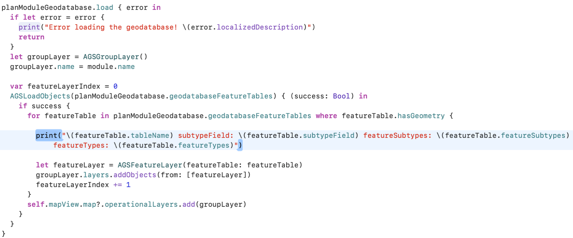
I know the HFDHarvestPoly layer has subtype defined but as you can see the subtypeField and featureSubtypes are empty:

What am I doing wrong? Would you have any idea of how to implement subtype support?
Thanks,
Shimin
- Mark as New
- Bookmark
- Subscribe
- Mute
- Subscribe to RSS Feed
- Permalink
Hmm. Thanks for the info, Shimin Cai. I'm doing some digging. Where is this feature service hosted? ArcGIS Online or ArcGIS Enterprise? If Enterprise, what version?
- Mark as New
- Bookmark
- Subscribe
- Mute
- Subscribe to RSS Feed
- Permalink
Hi Nick,
It's is ArcGIS Enterprise 10.4.1.
Thanks,
Shimin
- Mark as New
- Bookmark
- Subscribe
- Mute
- Subscribe to RSS Feed
- Permalink
Thank you. I sent you a DM with some more questions.
- Mark as New
- Bookmark
- Subscribe
- Mute
- Subscribe to RSS Feed
- Permalink
I replied to that DM with the feature service json.
- Mark as New
- Bookmark
- Subscribe
- Mute
- Subscribe to RSS Feed
- Permalink
Hi Nick,
Here is the feature service json:
{"currentVersion":10.41,"serviceDescription":"HFDSUper","hasVersionedData":false,"supportsDisconnectedEditing":false,"syncEnabled":true,"syncCapabilities":{"supportsRegisteringExistingData":true,"supportsSyncDirectionControl":true,"supportsPerLayerSync":true,"supportsPerReplicaSync":false,"supportsRollbackOnFailure":false,"supportsAsync":true,"supportsAttachmentsSyncDirection":true,"supportsSyncModelNone":true},"supportedQueryFormats":"JSON, AMF","maxRecordCount":100000,"capabilities":"Create,Delete,Extract,Query,Sync,Update,Uploads,Editing","description":"","copyrightText":"robk","spatialReference":{"wkid":3308,"latestWkid":3308},"initialExtent":{"xmin":9860167.134816462,"ymin":4946953.487653883,"xmax":9860835.390870487,"ymax":4947364.722148668,"spatialReference":{"wkid":3308,"latestWkid":3308}},"fullExtent":{"xmin":0,"ymin":-3622637.5840000007,"xmax":1.03139531981E7,"ymax":5858939.346900001,"spatialReference":{"wkid":3308,"latestWkid":3308}},"allowGeometryUpdates":true,"supportsApplyEditsWithGlobalIds":true,"units":"esriMeters","documentInfo":{"Title":"","Author":"","Comments":"HFDSUper","Subject":"HFDSUper","Category":"","Keywords":"HFD"},"layers":[{"id":0,"name":"HFD_Planpolys"},{"id":1,"name":"HFD_Planlines"},{"id":2,"name":"HFDHarvestLine"},{"id":3,"name":"HFD_KoalaStarLine"},{"id":4,"name":"HFD_KoalaStarTree"},{"id":5,"name":"HFDHarvestPoly"},{"id":6,"name":"HFDHarvestPoint"},{"id":7,"name":"HFD_Planpoints"},{"id":8,"name":"HFD_Trees"},{"id":9,"name":"HFDCrossing"},{"id":10,"name":"HFDContractorTree"},{"id":11,"name":"HFDNonCompliance"},{"id":12,"name":"HFD_Dump"},{"id":13,"name":"HFD_IncidentalFF"},{"id":14,"name":"HFDNote"},{"id":15,"name":"Hazard"},{"id":16,"name":"TempNoGoZone"}],"tables":[],"enableZDefaults":false}Thanks,
Shimin
- Mark as New
- Bookmark
- Subscribe
- Mute
- Subscribe to RSS Feed
- Permalink
Thanks. Could you also share the JSON for layer 5 please?
- Mark as New
- Bookmark
- Subscribe
- Mute
- Subscribe to RSS Feed
- Permalink
Hi Nick,
Layer 6 has subtype and here is the json:
{"currentVersion":10.41,"id":6,"name":"HFDHarvestPoly","type":"Feature Layer","description":"","copyrightText":"","defaultVisibility":false,"editFieldsInfo":{"creationDateField":"created_date","editDateField":"last_edited_date"},"ownershipBasedAccessControlForFeatures":null,"syncCanReturnChanges":true,"relationships":[],"isDataVersioned":false,"supportsRollbackOnFailureParameter":true,"supportsStatistics":true,"supportsAdvancedQueries":true,"supportsValidateSQL":true,"supportsCalculate":false,"advancedQueryCapabilities":{"supportsPagination":true,"supportsQueryWithDistance":true,"supportsReturningQueryExtent":true,"supportsStatistics":true,"supportsOrderBy":true,"supportsDistinct":true},"geometryType":"esriGeometryPolygon","minScale":200000,"maxScale":0,"extent":{"xmin":746841.3055000007,"ymin":4034351.2918999996,"xmax":9901071.460900001,"ymax":5858939.346900001,"spatialReference":{"wkid":3308,"latestWkid":3308}},"drawingInfo":{"renderer":{"type":"uniqueValue","field1":"PointType","field2":null,"field3":null,"fieldDelimiter":", ","defaultSymbol":null,"defaultLabel":null,"uniqueValueInfos":[{"symbol":{"type":"esriSFS","style":"esriSFSSolid","color":[0,0,0,0],"outline":{"type":"esriSLS","style":"esriSLSSolid","color":[255,170,0,255],"width":4}},"value":"3","label":"UnClassified","description":""},{"symbol":{"type":"esriSFS","style":"esriSFSSolid","color":[0,0,0,0],"outline":{"type":"esriSLS","style":"esriSLSSolid","color":[255,0,197,255],"width":4}},"value":"1","label":"NonHarvestPoly","description":""},{"symbol":{"type":"esriSFS","style":"esriSFSSolid","color":[0,0,0,0],"outline":{"type":"esriSLS","style":"esriSLSSolid","color":[78,78,78,255],"width":4}},"value":"0","label":"HarvestedPoly","description":""}]},"transparency":0,"labelingInfo":null},"hasM":false,"hasZ":false,"allowGeometryUpdates":true,"hasAttachments":false,"supportsApplyEditsWithGlobalIds":true,"htmlPopupType":"esriServerHTMLPopupTypeAsHTMLText","objectIdField":"OBJECTID","globalIdField":"GlobalID","displayField":"Notes","typeIdField":"PointType","fields":[{"name":"PointType","type":"esriFieldTypeInteger","alias":"PoinType","domain":null,"editable":true,"nullable":true},{"name":"HarvestDetails","type":"esriFieldTypeInteger","alias":"HarvestDetails","domain":null,"editable":true,"nullable":true},{"name":"Notes","type":"esriFieldTypeString","alias":"Notes","domain":null,"editable":true,"nullable":true,"length":500},{"name":"GlobalID","type":"esriFieldTypeGlobalID","alias":"GlobalID","domain":null,"editable":false,"nullable":false,"length":38},{"name":"created_user","type":"esriFieldTypeString","alias":"created_user","domain":null,"editable":true,"nullable":true,"length":255},{"name":"created_date","type":"esriFieldTypeDate","alias":"created_date","domain":null,"editable":false,"nullable":true,"length":8},{"name":"last_edited_user","type":"esriFieldTypeString","alias":"last_edited_user","domain":null,"editable":true,"nullable":true,"length":255},{"name":"last_edited_date","type":"esriFieldTypeDate","alias":"last_edited_date","domain":null,"editable":false,"nullable":true,"length":8},{"name":"OBJECTID","type":"esriFieldTypeOID","alias":"OBJECTID","domain":null,"editable":false,"nullable":false},{"name":"PlanID","type":"esriFieldTypeString","alias":"SHAPE.STArea())","domain":null,"editable":false,"nullable":true,"length":50},{"name":"PlanName","type":"esriFieldTypeString","alias":"PlanName","domain":null,"editable":true,"nullable":true,"length":150}],"indexes":[{"name":"UUID_282","fields":"GlobalID","isAscending":true,"isUnique":true,"description":""},{"name":"gdb_ct3_282","fields":"OBJECTID","isAscending":true,"isUnique":false,"description":""},{"name":"S159_idx","fields":"SHAPE","isAscending":true,"isUnique":true,"description":""}],"dateFieldsTimeReference":{"timeZone":"UTC","respectsDaylightSaving":false},"types":[{"id":3,"name":"UnClassified","domains":{},"templates":[{"name":"UnClassified","description":"","prototype":{"attributes":{"PointType":3,"HarvestDetails":null,"Notes":null,"PlanName":null,"created_user":null,"last_edited_user":null}},"drawingTool":"esriFeatureEditToolPolygon"}]},{"id":1,"name":"NonHarvestPoly","domains":{"HarvestDetails":{"type":"codedValue","name":"DmHFDNoHarvest","codedValues":[{"name":"BA Offset","code":21},{"name":"Topo Inaccessible","code":22},{"name":"Steep","code":23},{"name":"Uneconomic","code":24},{"name":"Env Protection","code":25},{"name":"Pre-Merch","code":26},{"name":"Unlogged Missed","code":27},{"name":"Unlogged Other","code":28},{"name":"Alternate Coupe","code":29},{"name":"Unknown","code":31},{"name":"Other - see notes","code":8}]}},"templates":[{"name":"NonHarvestPoly","description":"","prototype":{"attributes":{"PointType":1,"HarvestDetails":null,"Notes":null,"PlanName":null,"created_user":null,"last_edited_user":null}},"drawingTool":"esriFeatureEditToolPolygon"}]},{"id":0,"name":"HarvestedPoly","domains":{"HarvestDetails":{"type":"codedValue","name":"DmHFDSiviculture","codedValues":[{"name":"STS Light","code":1},{"name":"STS Medium","code":2},{"name":"STS Heavy","code":3},{"name":"STS Regen","code":4},{"name":"AGS","code":5},{"name":"Thinning","code":6},{"name":"Other - see notes","code":8},{"name":"Clearfell","code":9},{"name":"STS Release","code":7},{"name":"Early Thinning","code":10},{"name":"Alternate Coupe","code":11}]}},"templates":[{"name":"HarvestedPoly","description":"","prototype":{"attributes":{"PointType":0,"HarvestDetails":2,"Notes":null,"PlanName":null,"created_user":null,"last_edited_user":null}},"drawingTool":"esriFeatureEditToolPolygon"}]}],"templates":[],"maxRecordCount":10000,"supportedQueryFormats":"JSON, AMF, geoJSON","capabilities":"Create,Delete,Extract,Query,Sync,Update,Uploads,Editing","useStandardizedQueries":true}


I noticed a layer id discrepancy between the layer json and the service json: the layer id in the service json is 5 but 6 in the service json. Not sure why...

The layer list in the service directory:


Thanks,

Shimin
Thanks,
Shimin