- Home
- :
- All Communities
- :
- Developers
- :
- Native Maps SDKs
- :
- Runtime SDK for iOS Questions
- :
- Re: AGSIdentifyParameters not receiving according ...
- Subscribe to RSS Feed
- Mark Topic as New
- Mark Topic as Read
- Float this Topic for Current User
- Bookmark
- Subscribe
- Mute
- Printer Friendly Page
AGSIdentifyParameters not receiving according to order on Server, always get in Ascending Order.
- Mark as New
- Bookmark
- Subscribe
- Mute
- Subscribe to RSS Feed
- Permalink
hello,
This is very strange , as from my Server site i have below Parameters for one of the Layers...
Fields:
FID (Type: esriFieldTypeOID, Alias: FID)
Shape (Type: esriFieldTypeGeometry, Alias: Shape)
APN (Type: esriFieldTypeString, Alias: APN, Length: 11 )
PREVIOUSAP (Type: esriFieldTypeString, Alias: PREVIOUSAP, Length: 200 )
AREA (Type: esriFieldTypeDouble, Alias: AREA)
ACRES (Type: esriFieldTypeDouble, Alias: ACRES)
ZONING (Type: esriFieldTypeString, Alias: ZONING, Length: 25 )
VAC (Type: esriFieldTypeString, Alias: VAC, Length: 1 )
EVAC (Type: esriFieldTypeString, Alias: EVAC, Length: 5 )
FIRE (Type: esriFieldTypeString, Alias: FIRE, Length: 5 )
ZMASK (Type: esriFieldTypeString, Alias: ZMASK, Length: 16 )
PERIMETER (Type: esriFieldTypeDouble, Alias: PERIMETER)
PC_LANDUSE (Type: esriFieldTypeString, Alias: PC_LANDUSE, Length: 2 )
TRACT (Type: esriFieldTypeString, Alias: TRACT, Length: 16 )
BOOK (Type: esriFieldTypeString, Alias: BOOK, Length: 3 )
TIF (Type: esriFieldTypeString, Alias: TIF, Length: 40 )
LOTNO (Type: esriFieldTypeString, Alias: LOTNO, Length: 5 )
TEMP (Type: esriFieldTypeString, Alias: TEMP, Length: 6 )
CENSUS (Type: esriFieldTypeString, Alias: CENSUS, Length: 9 )
GP (Type: esriFieldTypeString, Alias: GP, Length: 25 )
Type ID Field: N/A
i can access all the parameters or GIS Attributes from my iPAD app with below code...
self.m_identifyParams.layerIds=arrLayerIDs; // Layer ID
self.m_identifyParams.tolerance = 3;
self.m_identifyParams.geometry = env;
self.m_identifyParams.size = self.m_mapView.bounds.size;
self.m_identifyParams.mapEnvelope = self.m_mapView.visibleArea.envelope;
self.m_identifyParams.returnGeometry = YES;
self.m_identifyParams.layerOption = AGSIdentifyParametersLayerOptionAll;
self.m_identifyParams.spatialReference = self.m_mapView.spatialReference;
[self.m_identifyTask executeWithParameters:self.m_identifyParams];
- (void)identifyTask:(AGSIdentifyTask *)m_identifyTask operation:(NSOperation *)op didExecuteWithIdentifyResults:(NSArray *)results
but what i am getting IdentifyResults is as in below Order Ascending Order:
ACRES = "15.59";
APN = "038-240-022";
AREA = "678953.526";
BOOK = 038;
CENSUS = "";
EVAC = "";
FID = 5221;
FIRE = "";
GP = "ULDR - 2 DU/Ac CD/OSP";
LOTNO = "";
"PC_LANDUSE" = 00;
PERIMETER = "4375.32";
PREVIOUSAP = "";
Shape = Polygon;
TEMP = "";
TIF = "http://gis/data/mapbks/bk038/03824.00";
TRACT = "056-037";
VAC = P;
ZMASK = "Placer County";
ZONING = "Placer County";
but i wish to get in same order as above from server Fields: , starting from FID, Shape ETC...
Solved! Go to Solution.
Accepted Solutions
- Mark as New
- Bookmark
- Subscribe
- Mute
- Subscribe to RSS Feed
- Permalink
AGSField is an object and not a dictionary. So if you access either of the 53 objects, cast it to AGSField and print the `name` property you should see the right values.
Refer to AGSField object.
This is what I got:
(lldb) po ((AGSField*)((AGSFeatureLayer*)layer).fields[0]).name
OBJECTID
- Mark as New
- Bookmark
- Subscribe
- Mute
- Subscribe to RSS Feed
- Permalink
Is that the list of attributes on a feature/graphic returned by identifyTask? If yes, then since `allAttributes` property is an `NSDictionary`, you cannot preserve the order. Otherwise, can you elaborate on how you are accessing these properties?
- Mark as New
- Bookmark
- Subscribe
- Mute
- Subscribe to RSS Feed
- Permalink
yes, it is identifyTask. i access 'allAttributes' which is NSDictionary, from - (void)identifyTask:(AGSIdentifyTask *)m_identifyTask operation:(NSOperation *)op didExecuteWithIdentifyResults:(NSArray *)results
callback return on success method.
so in iPad(IOS SDK of ESRI) it is not possible. and i will always get in Ascending order....... and not according on attributes on a feature/graphic Layer.
it was requirement to display attributes as it is..from server... if possible any workaround...
- Mark as New
- Bookmark
- Subscribe
- Mute
- Subscribe to RSS Feed
- Permalink
One workaround I can think of is creating an array of ordered keys : ["FID", "Shape", "APN", .... ]. Then looping through the array and getting the value corresponding to each key.
- Mark as New
- Bookmark
- Subscribe
- Mute
- Subscribe to RSS Feed
- Permalink
sorry that won't be possible as different Layers will have diff, Attributes...also no. of attributes differs.... also diff clients have different MAPs....so i guess i have to go ahead with Order what i get...
- Mark as New
- Bookmark
- Subscribe
- Mute
- Subscribe to RSS Feed
- Permalink
Hello,
there is no way even to access Layers Fields name...?
there should be method to access simple Layers Fields name.... and those will give me in proper order ....
- Mark as New
- Bookmark
- Subscribe
- Mute
- Subscribe to RSS Feed
- Permalink
AGSFeatureLayer has a property `fields` you can use to get the fields in the right order. Simply create a feature layer using the URL and inside layerDidLoad, you should have the fields in the right order.
Let me know if this helps.
Gagan
- Mark as New
- Bookmark
- Subscribe
- Mute
- Subscribe to RSS Feed
- Permalink
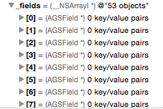
sorry, i tried Esri sample example itself.... GenerateRendererSample .... with all possible ways..but fields getting 0 key element...it does show 53 elements but all are 0
initWithString:FEATURE_SERVICE_URL = http://sampleserver6.arcgisonline.com/arcgis/rest/services/Census/MapServer/2
//initialize the feature layer and assign the delegate
self.featureLayer = [[AGSFeatureLayer alloc] initWithURL:[[NSURL alloc] initWithString:FEATURE_SERVICE_URL] mode:AGSFeatureLayerModeSnapshot];
self.featureLayer.delegate = self;
//using definition expression to get counties(features) for just California
With below code commented or without commented
self.featureLayer.definitionExpression = @"state_name = 'California'";
self.featureLayer.outFields = @[@"*"];
[self.mapView addMapLayer:self.featureLayer];
-(void)layerDidLoad:(AGSLayer *)layer {
//once the feature layer gets loaded
//assign the layer's fields to the legend view controller
self.legendViewController.classificationFields = self.featureLayer.fields;
}
layer.field ==> 0 key/value pair for all 53 fields
self.featureLayer.fields==> 0 key/value pair for all 53 fields
- Mark as New
- Bookmark
- Subscribe
- Mute
- Subscribe to RSS Feed
- Permalink
AGSField is an object and not a dictionary. So if you access either of the 53 objects, cast it to AGSField and print the `name` property you should see the right values.
Refer to AGSField object.
This is what I got:
(lldb) po ((AGSField*)((AGSFeatureLayer*)layer).fields[0]).name
OBJECTID