- Home
- :
- All Communities
- :
- Developers
- :
- Native Maps SDKs
- :
- Runtime SDK for Android Questions
- :
- Re: How do i create polygon using mapviewhelper ?
- Subscribe to RSS Feed
- Mark Topic as New
- Mark Topic as Read
- Float this Topic for Current User
- Bookmark
- Subscribe
- Mute
- Printer Friendly Page
- Mark as New
- Bookmark
- Subscribe
- Mute
- Subscribe to RSS Feed
- Permalink
This is my code, but not working, is there any thing wrong !?
public void createPolygon() {
arcMap.addLayer(graphicsLayer);
String url = "http://.../polygons.json";
final String resp = StudioUtilities.sendGetRequest(url);
arcMap.setOnStatusChangedListener(new OnStatusChangedListener() {
private static final long serialVersionUID = 1L;
public void onStatusChanged(Object source, STATUS status) {
try {
JSONObject jsonObject = new JSONObject(resp);
JSONArray jsonArray = jsonObject.getJSONArray("polygons");
int count = 0;
while (count < jsonArray.length()) {
JSONObject polygon = jsonArray.getJSONObject(count);
JSONObject borderObject = polygon.getJSONObject("border");
JSONObject startPointObject = polygon.getJSONObject("starting_point");
final JSONArray pointsArray = polygon.getJSONArray("points");
double[][] p = {
{
33.599389, -7.610728
},
{
33.599985, -7.597180
},
{
33.588879, -7.617027
}
};
int loaded = mvHelper.addPolygonGraphic(p, "pol_t", "pol_st", "", Color.GREEN, Color.DKGRAY, 2, 0);
if (loaded < 0) {
Toast.makeText(ctx, "Marker Graphic not added to MapView", Toast.LENGTH_SHORT).show();
} else {
Toast.makeText(ctx, "Marker Graphic is added to MapView", Toast.LENGTH_SHORT).show();
}
count++;
}
} catch (JSONException e) {
e.printStackTrace();
}
});
}
Solved! Go to Solution.
Accepted Solutions
- Mark as New
- Bookmark
- Subscribe
- Mute
- Subscribe to RSS Feed
- Permalink
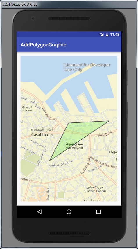
Create the color this way:
Color.argb(50, 49, 247, 10)
The first value is the alpha value which is showing 50% transparency.
Therefore, the line would look like this:
int graphic = mapViewHelper.addPolygonGraphic(latLon,"pol_t", "pol_st", "", Color.argb(50, 49, 247, 10), Color.DKGRAY,2, 0);
If this helped resolve the issue, would you kindly select this as the correct answer.
The attached screenshot is what I got below for the above snippet:
- Mark as New
- Bookmark
- Subscribe
- Mute
- Subscribe to RSS Feed
- Permalink
Are you getting any errors or tracebacks when running?
- Mark as New
- Bookmark
- Subscribe
- Mute
- Subscribe to RSS Feed
- Permalink
No, but i need your help to fill the 2 dimensional array (double[][] p) from the points Array :
polygons: [
{
- title: "t_poly1",
- subtitle: "subt_poly1",
- background: "green",
- border: {
- color: "darkgray",
- size: 2,
- style: "solid"
- points: [
{
latitude: "33.6060236",
longitude: "-7.630058"
},{
latitude: "33.601975",
longitude: "-7.632489"
},
{
latitude: "33.605867",
longitude: "-7.635220"
},
- {
latitude: "33.605626",
longitude: "-7.632988"
}
]
]
- Mark as New
- Bookmark
- Subscribe
- Mute
- Subscribe to RSS Feed
- Permalink
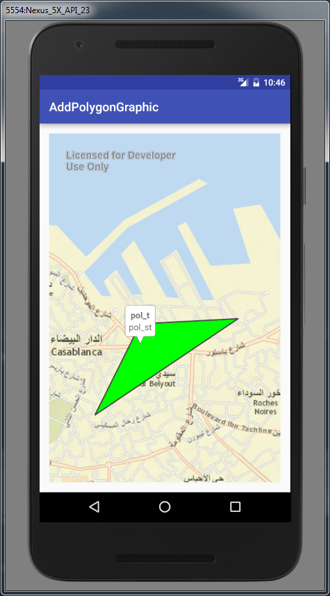
Hello Mohamed EzzerI,
I was able to get the feature to draw in Casablanca using the following snippet:
package com.arcgis.androidsupportcases.addpolygongraphic;

import android.graphics.Color;
import android.support.v7.app.AppCompatActivity;
import android.os.Bundle;
import android.util.Log;
import com.esri.android.map.MapView;
import com.esri.android.map.event.OnStatusChangedListener;
import com.esri.android.toolkit.map.MapViewHelper;

public class MainActivity extends AppCompatActivity {

  MapView mapView;

  @Override protected void onCreate(Bundle savedInstanceState) {
   super.onCreate(savedInstanceState);
   setContentView(R.layout.activity_main);

   mapView = (MapView) findViewById(R.id.map);
   mapView.setOnStatusChangedListener(new OnStatusChangedListener() {
   @Override public void onStatusChanged(Object o, STATUS status) {
   if (status == STATUS.INITIALIZED) {
  MapViewHelper mapViewHelper = new MapViewHelper(mapView);
  double[][] latLon = new double[][] {{
   33.599389, -7.610728
   },
   {
   33.599985, -7.597180
   },
   {
   33.588879, -7.617027
   }
  };
  int graphic = mapViewHelper.addPolygonGraphic(latLon,"pol_t", "pol_st", "", Color.GREEN, Color.DKGRAY,2, 0);
   Log.e("NOHE", "" + graphic);
   }
  }
  });

  }
}
Here is the screenshot of my end result:
- Mark as New
- Bookmark
- Subscribe
- Mute
- Subscribe to RSS Feed
- Permalink
^^ , it worked for me, filling the array statically , but what i need is to gather data from the json, if it is possible
- Mark as New
- Bookmark
- Subscribe
- Mute
- Subscribe to RSS Feed
- Permalink
Thnks Alexander, i hope that you could help me to solve this problem, i already tried to fill the p array using this code, but the app crashes :
double[][] p = new double[2][pointsArray.length()];
int pointCount = 0;
while (pointCount < pointsArray.length()) {
try {
final JSONObject point = pointsArray.getJSONObject(pointCount);
p[0][pointCount] = Double.parseDouble(point.getString("latitude"));
p[1][pointCount] = Double.parseDouble(point.getString("longitude"));
} catch (JSONException e) {
e.printStackTrace();
}
pointCount++;
}
- Mark as New
- Bookmark
- Subscribe
- Mute
- Subscribe to RSS Feed
- Permalink
double[][] p = new double[pointsArray.length()][2];
The points array would be the outside array which would contain the amount of points. I believe that you have this backwards. As well as this:
p[pointCount][0] = Double.parseDouble(point.getString("latitude"));
p[pointCount][1] = Double.parseDouble(point.getString("longitude"));
- Mark as New
- Bookmark
- Subscribe
- Mute
- Subscribe to RSS Feed
- Permalink
Thx a lot, it worked  ,
,
one more issue, is polygon FillStyle, i won't it solid, cuz it covers the map, is there any suggestion
- Mark as New
- Bookmark
- Subscribe
- Mute
- Subscribe to RSS Feed
- Permalink
Create the color this way:
Color.argb(50, 49, 247, 10)
The first value is the alpha value which is showing 50% transparency.
Therefore, the line would look like this:
int graphic = mapViewHelper.addPolygonGraphic(latLon,"pol_t", "pol_st", "", Color.argb(50, 49, 247, 10), Color.DKGRAY,2, 0);
If this helped resolve the issue, would you kindly select this as the correct answer.
The attached screenshot is what I got below for the above snippet: