- Home
- :
- All Communities
- :
- Developers
- :
- ArcGIS REST APIs and Services
- :
- ArcGIS REST APIs & Services Ques.
- :
- I need help projecting NAD83 (2011) from stateplan...
- Subscribe to RSS Feed
- Mark Topic as New
- Mark Topic as Read
- Float this Topic for Current User
- Bookmark
- Subscribe
- Mute
- Printer Friendly Page
I need help projecting NAD83 (2011) from stateplane to lat lon
- Mark as New
- Bookmark
- Subscribe
- Mute
- Subscribe to RSS Feed
- Permalink
I am trying to project coordinates in an asp.net page by calling a geometry service through the rest api. I am using the geometry service at "http://tasks.arcgisonline.com/ArcGIS/rest/services/Geometry/GeometryServer/project". I want to convert from stateplane x,y to latitude, longitude.
Here is a screen shot:
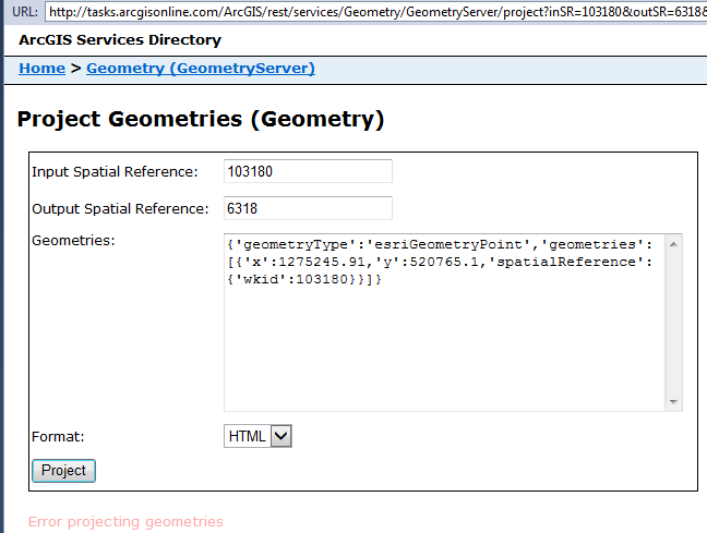
Am I doing something wrong? is it possible to project from NAD_1983_2011_StatePlane...(103180) to GCS_NAD_1983_2011 (6318)?
Thanks for any help!
Janice.
Solved! Go to Solution.
Accepted Solutions
- Mark as New
- Bookmark
- Subscribe
- Mute
- Subscribe to RSS Feed
- Permalink
Janice, you certainly should be able to. I'm not able to get 103180 nor 6318 to work, but was able to get 3690 and 4759 (the same but on NSRS2007) to work. When I checked the home page, it said the version was 10.04. You would need to find or create a geometry service that using a later version.
- Mark as New
- Bookmark
- Subscribe
- Mute
- Subscribe to RSS Feed
- Permalink
I looked into this issue about a year ago and at that time there wasn't a good translation from the 2011 datum to just about anything. There were some other discussion threads that talked about this but I would recommend you contact ESRI directly to see where things are with this. You might also look at the National Geodetic Survey website:
- Mark as New
- Bookmark
- Subscribe
- Mute
- Subscribe to RSS Feed
- Permalink
Melita Kennedy, got anything on this?
- Mark as New
- Bookmark
- Subscribe
- Mute
- Subscribe to RSS Feed
- Permalink
Janice, you certainly should be able to. I'm not able to get 103180 nor 6318 to work, but was able to get 3690 and 4759 (the same but on NSRS2007) to work. When I checked the home page, it said the version was 10.04. You would need to find or create a geometry service that using a later version.