- Home
- :
- All Communities
- :
- Developers
- :
- ArcGIS REST APIs and Services
- :
- ArcGIS REST APIs & Services Ques.
- :
- Data accuracy (ArcGIS JS vs ArcGIS REST API)
- Subscribe to RSS Feed
- Mark Topic as New
- Mark Topic as Read
- Float this Topic for Current User
- Bookmark
- Subscribe
- Mute
- Printer Friendly Page
- Mark as New
- Bookmark
- Subscribe
- Mute
- Subscribe to RSS Feed
- Permalink
Hi guys.
I have a problem with the data accuracy between the ArcGIS REST API and ArcGIS JavaScript. I developed a radius feature to query geometry on the map. When I query geometry on the map via the ArGIS JS web application, the total data count is 2. However, when I query geometry the map using the ArcGIS REST API, the total data count is 3. Is there a part I am missing in this process?
I have posted two screenshots here, Postman and web application.
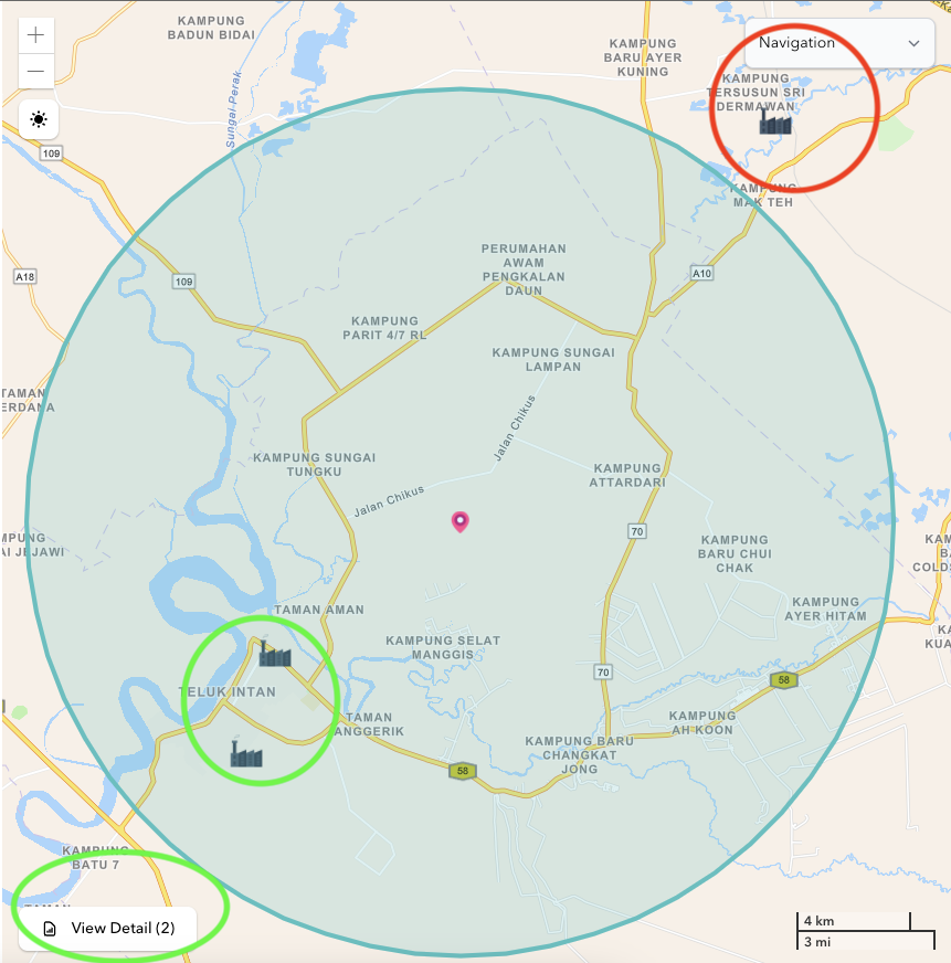
Screenshot from web:
The actual radius is the green ring with low background. Distance is 15KM. The 2 greens that I marked are actual data that display count only 2. And red is the data outside of radius. So the filter should take data inside radius only.
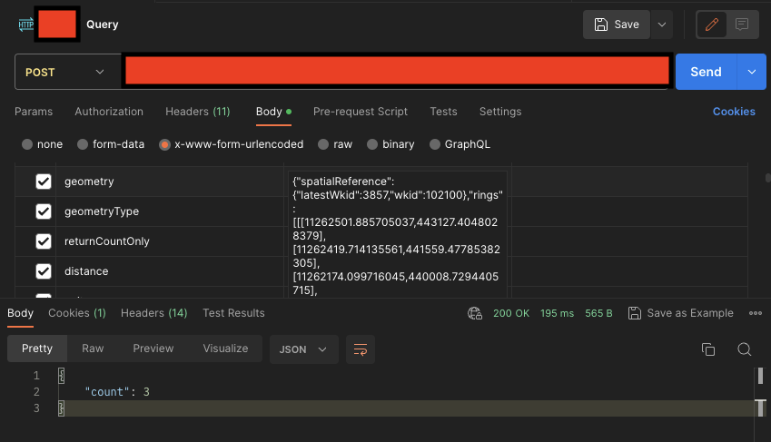
Screenshot from postman:
When I query via Postman, use same query geometry like radius web. Same distance 15KM. The count returns 3.
This is my form data:
f: json
distance: 15
geometry: {"rings":[[[11385142.858222554,672603.1577095101],[11385060.686653078,671035.2307604953],[11384815.072233561,669484.4823472437],[11384408.705966981,667967.9027938859],[11383846.040087193,666502.108063373],[11383133.23927932,665103.1577095101],[11382278.113138178,663786.378925123],[11381290.030604715,662566.1986141272],[11380179.817317937,661455.9853273492],[11378959.63700694,660467.9027938859],[11377642.858222554,659612.7766527435],[11376243.90786869,658899.975844871],[11374778.113138178,658337.3099650828],[11373261.53358482,657930.943698503],[11371710.785171568,657685.329278986],[11370142.858222554,657603.1577095101],[11368574.931273539,657685.329278986],[11367024.182860287,657930.943698503],[11365507.603306929,658337.3099650828],[11364041.808576416,658899.975844871],[11362642.858222554,659612.7766527435],[11361326.079438167,660467.9027938859],[11360105.89912717,661455.9853273492],[11358995.685840392,662566.1986141272],[11358007.603306929,663786.378925123],[11357152.477165787,665103.1577095101],[11356439.676357914,666502.108063373],[11355877.010478126,667967.9027938859],[11355470.644211546,669484.4823472437],[11355225.02979203,671035.2307604953],[11355142.858222554,672603.1577095101],[11355225.02979203,674171.0846585248],[11355470.644211546,675721.8330717764],[11355877.010478126,677238.4126251342],[11356439.676357914,678704.2073556471],[11357152.477165787,680103.1577095101],[11358007.603306929,681419.9364938971],[11358995.685840392,682640.1168048929],[11360105.89912717,683750.330091671],[11361326.079438167,684738.4126251342],[11362642.858222554,685593.5387662767],[11364041.808576416,686306.3395741491],[11365507.603306929,686869.0054539373],[11367024.182860287,687275.3717205172],[11368574.931273539,687520.9861400342],[11370142.858222554,687603.1577095101],[11371710.785171568,687520.9861400342],[11373261.53358482,687275.3717205172],[11374778.113138178,686869.0054539373],[11376243.90786869,686306.3395741491],[11377642.858222554,685593.5387662767],[11378959.63700694,684738.4126251342],[11380179.817317937,683750.330091671],[11381290.030604715,682640.1168048929],[11382278.113138178,681419.9364938971],[11383133.23927932,680103.1577095101],[11383846.040087193,678704.2073556471],[11384408.705966981,677238.4126251342],[11384815.072233561,675721.8330717764],[11385060.686653078,674171.0846585248],[11385142.858222554,672603.1577095101]]]}
resultOffset: 0
resultRecordCount: 10
where: 1=1
outFields: *
spatialRel: esriSpatialRelIntersects
geometryType: esriGeometryPolygon
inSR: 102100
outSR: 102100
Solved! Go to Solution.
Accepted Solutions
- Mark as New
- Bookmark
- Subscribe
- Mute
- Subscribe to RSS Feed
- Permalink
Okay solved. I need to ditch "units" parameter.
- Mark as New
- Bookmark
- Subscribe
- Mute
- Subscribe to RSS Feed
- Permalink
Okay solved. I need to ditch "units" parameter.