- Home
- :
- All Communities
- :
- Developers
- :
- ArcGIS REST APIs and Services
- :
- ArcGIS REST APIs & Services Ques.
- :
- addfeature to Arcgis Online using REST API
- Subscribe to RSS Feed
- Mark Topic as New
- Mark Topic as Read
- Float this Topic for Current User
- Bookmark
- Subscribe
- Mute
- Printer Friendly Page
- Mark as New
- Bookmark
- Subscribe
- Mute
- Subscribe to RSS Feed
- Permalink
hi
i am making a movile app and try only to add points to a feature service on arcgis online, get the xy from the celphones gps and sent it with other information through REST API and all the information was saved correct but the point always appear on 0,0
facts :
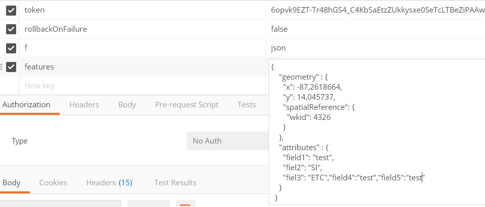
1 .X an Y coordenates get from the GPS ( cellphone ) the values are digital degrees 14,045737 , -86.2618664
2. get token fine
3. sent to the REST and the record was saved without error
4. the feature is on Arcgis Online and is point feature
5. when i check the map the point is 0,0
6. I also try removing the spatialreference parameter and only put geometry and also went to 0,0
don't know what happend, shoul'd i have to make a coordenate convertion?
thanks
Solved! Go to Solution.
Accepted Solutions
- Mark as New
- Bookmark
- Subscribe
- Mute
- Subscribe to RSS Feed
- Permalink

Hi Marco Amaya,
Did you discover your mistake already?
Your code is fine, including the use of the spatialreference parameter, except for the fact that you are using comma's (",") instead of dots (".") as decimal separators in your X and Y values.
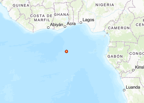
As soon as you have replaced the decimal separators you are good to go! With the coordinates you have given I end up on the southwestern outskirts of Tegucigalpa, Honduras, right?
HTH,
Egge-Jan
[
{
"geometry": {
"x": -87.2618664,
"y": 14.045737,
"spatialReference": {
"wkid": 4326
}
},
"attributes" : {
"field1" : "test",
"field2" : "SI",
"field3" : "EC",
"field4" : "test",
"field5" : "test"
}
}
]- Mark as New
- Bookmark
- Subscribe
- Mute
- Subscribe to RSS Feed
- Permalink
Hi Marco Amaya,
Did you discover your mistake already?
Your code is fine, including the use of the spatialreference parameter, except for the fact that you are using comma's (",") instead of dots (".") as decimal separators in your X and Y values.
As soon as you have replaced the decimal separators you are good to go! With the coordinates you have given I end up on the southwestern outskirts of Tegucigalpa, Honduras, right?
HTH,
Egge-Jan
[
{
"geometry": {
"x": -87.2618664,
"y": 14.045737,
"spatialReference": {
"wkid": 4326
}
},
"attributes" : {
"field1" : "test",
"field2" : "SI",
"field3" : "EC",
"field4" : "test",
"field5" : "test"
}
}
]- Mark as New
- Bookmark
- Subscribe
- Mute
- Subscribe to RSS Feed
- Permalink
Hi Marco Amaya,
If you think your issue is solved you may mark the answer as correct. In that way other GeoNet members can see that the call is closed.
TIA,
Egge-Jan