Turn on suggestions
Auto-suggest helps you quickly narrow down your search results by suggesting possible matches as you type.
Cancel
- Home
- :
- All Communities
- :
- Developers
- :
- ArcGIS Pro SDK
- :
- ArcGIS Pro SDK Questions
- :
- Problem with Raster.PixelToMap
Options
- Subscribe to RSS Feed
- Mark Topic as New
- Mark Topic as Read
- Float this Topic for Current User
- Bookmark
- Subscribe
- Mute
- Printer Friendly Page
Problem with Raster.PixelToMap
Subscribe
747
0
12-31-2021 05:05 PM
12-31-2021
05:05 PM
- Mark as New
- Bookmark
- Subscribe
- Mute
- Subscribe to RSS Feed
- Permalink
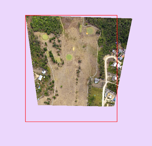
I wrote a bit of code to show me the extent (footprint) of a raster with a Polyline. It should be fairly simple by getting the map coordinates of four corner pixels of the raster. Yes, I'm aware that those should give me the coordinates of the center of those pixels, but that's fine. The code works fine for Rasters with orthogonal georeferencing, but has problems if the georeferencing rotates and stretches the image.
See screenshot below for the results I'm getting
await QueuedTask.Run(() =>
{
pOutLay = (FeatureLayer)LayerFactory.Instance.CreateLayer(new Uri(url), MapView.Active.Map);
pSpatRef = SpatialReferenceBuilder.CreateSpatialReference(32655); //UTM55N
EditOperation createFeatEditOp = new EditOperation();
createFeatEditOp.Name = "CreateImageEdges";
createFeatEditOp.SelectModifiedFeatures = false;
createFeatEditOp.SelectNewFeatures = false;
foreach (Item itm in items)
{
lstPnt = new List<MapPoint>();
string path = itm.Path.Substring(0, itm.Path.LastIndexOf(@"\"));
string strFile = itm.Path.Substring(itm.Path.LastIndexOf(@"\") + 1);
FileSystemConnectionPath connectionPath = new FileSystemConnectionPath(new System.Uri(path), FileSystemDatastoreType.Raster);
FileSystemDatastore dataStore = new FileSystemDatastore(connectionPath);
RasterDataset fileRasterDataset = dataStore.OpenDataset<RasterDataset>(strFile);
Raster pRas = fileRasterDataset.CreateDefaultRaster();
pTup = pRas.PixelToMap(0, 0);
lstPnt.Add(MapPointBuilder.CreateMapPoint(pTup.Item1, pTup.Item2));
pTup = pRas.PixelToMap(0, pRas.GetWidth());
lstPnt.Add(MapPointBuilder.CreateMapPoint(pTup.Item1, pTup.Item2));
pTup = pRas.PixelToMap(pRas.GetHeight(), pRas.GetWidth());
lstPnt.Add(MapPointBuilder.CreateMapPoint(pTup.Item1, pTup.Item2));
pTup = pRas.PixelToMap(pRas.GetHeight(), 0);
lstPnt.Add(MapPointBuilder.CreateMapPoint(pTup.Item1, pTup.Item2));
pTup = pRas.PixelToMap(0, 0);
lstPnt.Add(MapPointBuilder.CreateMapPoint(pTup.Item1, pTup.Item2));
pPline = PolylineBuilder.CreatePolyline(lstPnt, pSpatRef);
dctAtts = new Dictionary<string, object>();
dctAtts.Add("SHAPE", pPline);
dctAtts.Add("Image", strFile);
dctAtts.Add("Width", pRas.GetWidth());
dctAtts.Add("Height", pRas.GetHeight());
createFeatEditOp.Create(pOutLay, dctAtts);
}
createFeatEditOp.Execute();
});
}
catch (Exception ex)
{
MessageBox.Show(ex.Message);
}
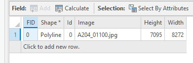
}The size of this image is 8272x6200 and you can see in the table that I'm not getting the correct height from the Raster object either.
Any idea what's going on here?


0 Replies