- Home
- :
- All Communities
- :
- Products
- :
- ArcGIS Pro
- :
- ArcGIS Pro Questions
- :
- Zoom-to/Pan-to/Flash Selected Feature not working ...
- Subscribe to RSS Feed
- Mark Topic as New
- Mark Topic as Read
- Float this Topic for Current User
- Bookmark
- Subscribe
- Mute
- Printer Friendly Page
Zoom-to/Pan-to/Flash Selected Feature not working in ArcGIS Pro with joined table
- Mark as New
- Bookmark
- Subscribe
- Mute
- Subscribe to RSS Feed
- Permalink
I have a project with a parcel feature class joined to a standalone table.
The join works great and I also have a definition query on the joined feature class that functions as expected. When I select a record in the attribute table and right click the record to zoom to it (or pan or flash, etc.), the entire data set flashes or it zooms to the entire extent and shows all features selected on my screen...even though only 1 record is selected in the table. At the bottom of the table it shows that only 1 record of the 28 is selected but I can't zoom to that feature. I also can't switch the table view to see just the selected records. This seems to be because of the join. When I take the join off, the zoom/flash/pan-to works fine and all functionality is back. Even when I remove the definition query (with the join remaining) I still have this problem...so it appears that the join is the issue. Has anyone else run into this issue? I really need to be able to work with the data in a joined fashion.

- Mark as New
- Bookmark
- Subscribe
- Mute
- Subscribe to RSS Feed
- Permalink
What version of Pro are you using?
What is the datasource of feature class and standalone? Are they even stored in the same datasource?
- Mark as New
- Bookmark
- Subscribe
- Mute
- Subscribe to RSS Feed
- Permalink
Version 2.1.1
The parcel polygon feature class and the table are both within the same file geodatabase.
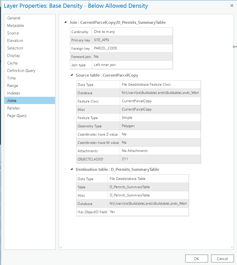
They are joined on unique Parcel Code ID (text field) (inner join). There are only about 300 records in the feature class.
Not indexed.
- Mark as New
- Bookmark
- Subscribe
- Mute
- Subscribe to RSS Feed
- Permalink
Not seeing this in 2.2.1. What version/types is the source data, how are you doing the joins, what types of fields are joined, are they indexed....
- Mark as New
- Bookmark
- Subscribe
- Mute
- Subscribe to RSS Feed
- Permalink
Version 2.1.1
The parcel polygon feature class and the table are both within the same file geodatabase.
They are joined on unique Parcel Code ID (text field) (inner join). There are only about 300 records in the feature class.
Not indexed.
- Mark as New
- Bookmark
- Subscribe
- Mute
- Subscribe to RSS Feed
- Permalink
Can you provide screenshot of inner join.
- Mark as New
- Bookmark
- Subscribe
- Mute
- Subscribe to RSS Feed
- Permalink
I just updated to 2.2.1 and the issue is still persisting.
- Mark as New
- Bookmark
- Subscribe
- Mute
- Subscribe to RSS Feed
- Permalink
It looks like a multipart shape (or something).
Could you find one feature that you know has only one feature and try it
- Mark as New
- Bookmark
- Subscribe
- Mute
- Subscribe to RSS Feed
- Permalink
Ya, I agree it's acting like multi-part, but it's not multipart. Unique parcels/shapes. If I "Keep All Target Features" it works in ArcGIS Pro (other than being painfully slow, almost a full minute to open the table). So I guess I could do that and then just use a definition query to get rid of seeing all the ones that didn't join.
FYI, the exact same process, data, join, etc...works perfectly in ArcMap 10.5.1 and is not slow at all. I can "keep common" and select/pan/zoom through the table with no problem.
Thanks for all the help suggestions!
