- Home
- :
- All Communities
- :
- Products
- :
- ArcGIS Pro
- :
- ArcGIS Pro Questions
- :
- Shape_Length and Shape_Area of Geographic Coordina...
- Subscribe to RSS Feed
- Mark Topic as New
- Mark Topic as Read
- Float this Topic for Current User
- Bookmark
- Subscribe
- Mute
- Printer Friendly Page
Shape_Length and Shape_Area of Geographic Coordinate Data
- Mark as New
- Bookmark
- Subscribe
- Mute
- Subscribe to RSS Feed
- Permalink
Suppose you have a spatial data expressed in a geographic coordinate system (eg WGS84).
Many geoprocessing tools, when operating on datasets, add one or two fields to the data: Shape_Length (for lines and polygons), and Shape_Area (for polygons). For instance, suppose you select certain polygons by pointing and clicking, and then request a new dataset be made from the selections -- you will get a new dataset with these two fields added (if they did not already exist). And the values in these fields will be measured in decimal degrees, or squared decimal degrees (I guess the latter should be called stedegrees, by analogy with steradians).
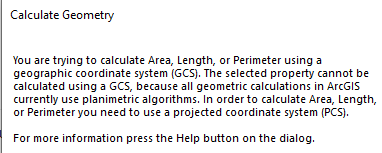
Now, if you take your same data, create a new column, click on that column, choose calculate geometry, and choose Use coordinate system of data source you will get an error. The message is to the effect that arcmap has no algorithm with which to make such a calculation (see attachment below).
So how then, or more importantly why, is that field being populated by other geoprocessing tools. Presumably the numbers are incorrect since arcmap says they have no algorithm to calculate them. A possible algorithm would, of course, be calculate the linear distance and then convert that to an angle by assuming it was a great circle arc on the earth's surface.
This is just one of many inconsistencies in the software.
- Mark as New
- Bookmark
- Subscribe
- Mute
- Subscribe to RSS Feed
- Permalink
Partially the software is inconsistent because there are multiple teams who are responsible for the various parts. Some teams are able to incorporate new functionality faster. It'll also depend on which version you're using.
For instance, the Add Geometry Attributes tool does support geodetic/geodesic-based lengths and areas.
Melita
- Mark as New
- Bookmark
- Subscribe
- Mute
- Subscribe to RSS Feed
- Permalink
...I realize this Post is 4 years old, but just in case you or anyone else is still tracking:
It's unclear to me whether this post/question is referring to Geodatabase Feature Classes or Shapefiles..?
...Because, of course, Shape_geometry fields (i.e. Shape_Length and Shape_Area) behave very differently in these two formats.
So, yes, if I have a Shapefile with Shape_geometry fields in geographic coordinates (degrees), how did that happen. ...I realize an export from a Geodatabase could provide this result ...But are there other ways?
For "long-timers", how did this occur with Shapefiles before the advent of the Geodatabase over 20 years ago?