- Home
- :
- All Communities
- :
- Products
- :
- ArcGIS Pro
- :
- ArcGIS Pro Questions
- :
- Raster Mosaic Dataset is not processing correctly
- Subscribe to RSS Feed
- Mark Topic as New
- Mark Topic as Read
- Float this Topic for Current User
- Bookmark
- Subscribe
- Mute
- Printer Friendly Page
Raster Mosaic Dataset is not processing correctly
- Mark as New
- Bookmark
- Subscribe
- Mute
- Subscribe to RSS Feed
- Permalink
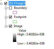
I use to be able to make Mosaic Datasets but now I can't. The geoprocessing goes fine and I receive no errors. However, when I view the two mosaic I made two this week using separate locations I get the same GRID values and the rasters I loaded are all grey with no texture.


Has anyone have an idea what step or option I am missing. I have recreated this issue in ArcMap and ArcGIS Pro 2.0.
Solved! Go to Solution.
Accepted Solutions
- Mark as New
- Bookmark
- Subscribe
- Mute
- Subscribe to RSS Feed
- Permalink
I had to Calculate Statistics.
- Mark as New
- Bookmark
- Subscribe
- Mute
- Subscribe to RSS Feed
- Permalink
Hi John,
If you click on the raster with Identify does it show the values that you would expect? If so you may just need to futz with the symbology options on the Image layer. Depending on how the rasters should be symbolized it may be necessary to add a function to your mosaic.
Sorry I don't have a more immediate answer! I don't have a ton of raster/mosaic dataset experience.
Micah
- Mark as New
- Bookmark
- Subscribe
- Mute
- Subscribe to RSS Feed
- Permalink
I had to Calculate Statistics.