- Home
- :
- All Communities
- :
- Products
- :
- ArcGIS Pro
- :
- ArcGIS Pro Questions
- :
- Raster Domain (3D Analyst Tools) output has no z v...
- Subscribe to RSS Feed
- Mark Topic as New
- Mark Topic as Read
- Float this Topic for Current User
- Bookmark
- Printer Friendly Page
Raster Domain (3D Analyst Tools) output has no z value

- Mark as New
- Bookmark
- Subscribe to RSS Feed
- Permalink
Hello,
I am trying to obtain two 3D polyline for two different digital elevation model rasters. The two 3D polylines can then be used to compare the two rasters and decide on the best vertical translation coefficient. The digital elevation models rasters are horizontally correct however one of the rasters is vertically unaligned.
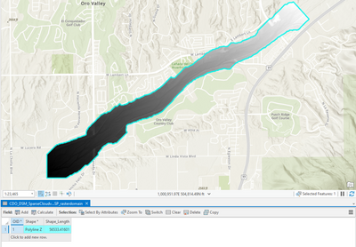
"Raster Domain (3D Analyst Tools)" seems perfect for the job but its polyline output did not have a z field. I also tried the "Update Feature Z (3D Analyst Tools)" to hopefully correct this very two dimensional line but also did not have any luck.
I have clipped the two digital elevations models to be the same size.
Any suggestions would be much appreciated. Thank you!
Solved! Go to Solution.
Accepted Solutions

- Mark as New
- Bookmark
- Subscribe to RSS Feed
- Permalink
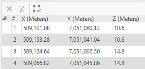
The Raster Domain tool creates a 3D feature with a Z value at each vertex, that's why there is no attribute with a single Z value. Your table shows the shape type as PolylineZ, so you can confirm the z values exist by selecting your polyline and going to the Edit menu and choosing the Edit Vertices tool.
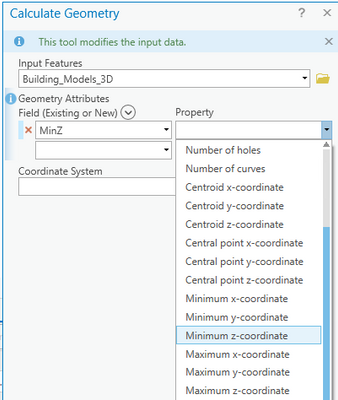
If you do want some simple Z attribute results you could use the Calculate Geometry tool on your output to get Min\Max Z or Centroid Z for example.
- Mark as New
- Bookmark
- Subscribe to RSS Feed
- Permalink
The Raster Domain tool creates a 3D feature with a Z value at each vertex, that's why there is no attribute with a single Z value. Your table shows the shape type as PolylineZ, so you can confirm the z values exist by selecting your polyline and going to the Edit menu and choosing the Edit Vertices tool.
If you do want some simple Z attribute results you could use the Calculate Geometry tool on your output to get Min\Max Z or Centroid Z for example.
- Mark as New
- Bookmark
- Subscribe to RSS Feed
- Permalink
Thank you very much for your explanation, that's all I needed!
