- Home
- :
- All Communities
- :
- Products
- :
- ArcGIS Pro
- :
- ArcGIS Pro Questions
- :
- Polygons with NULL or EMPTY geometry (negative are...
- Subscribe to RSS Feed
- Mark Topic as New
- Mark Topic as Read
- Float this Topic for Current User
- Bookmark
- Subscribe
- Mute
- Printer Friendly Page
Polygons with NULL or EMPTY geometry (negative area)
- Mark as New
- Bookmark
- Subscribe
- Mute
- Subscribe to RSS Feed
- Permalink
Hello,
I have a polygon feature class which contains features created on Field Maps and Collector on a layer in a Hosted Feature Service that was published from ArcMap (also a feature class in ArcMap at time of publishing to AGOL).
When getting all the information back to ArcGIS Pro (or ArcMap), the polygons behave in an odd way, for example: turning on labels does not work and nothing is on display on the map; when zooming in the features disappear (only in ArcMap not in ArcGIS Pro), and when using 'calculate geometry' in the attribute table, the area comes negative and I get the error message about having a NULL or EMPTY geometry (see screenshot attached).
However, if I add the polygon layer directly from AGOL onto ArcGIS Pro or ArcMap, everything (geometry and labels) displays correctly.
Does anyone know what could be the cause for this behaviour?
Thank you,
Rafa
Solved! Go to Solution.
Accepted Solutions
- Mark as New
- Bookmark
- Subscribe
- Mute
- Subscribe to RSS Feed
- Permalink
a negative area suggests that the outer rings are going in the opposite direction from what Pro expects, but sources of bad geometry can be numerous
Checking and repairing geometries—ArcGIS Pro | Documentation
enterprise gdb's try to fix those during several geoprocessing operations (some examples in the links).
A good Repair Geometry would be a useful step in your workflow
... sort of retired...
- Mark as New
- Bookmark
- Subscribe
- Mute
- Subscribe to RSS Feed
- Permalink
Ok thank you - I could've sworn I had already been trying the repair geometry tool and that's why I brought the problem to ESRI Community. I thought I'd give it another try to a new feature class exported from AGOL, same issue, and the tool did the job!
Should've made sure I checked that first, my bad.
Thank you though 🙂
- Mark as New
- Bookmark
- Subscribe
- Mute
- Subscribe to RSS Feed
- Permalink
Glad I found this but what would the reasoning for the negative areas. Using the ESRI prescribed workflow for taking large datasets off AGOL is resulting in polygon feature classes having negative areas.
- Mark as New
- Bookmark
- Subscribe
- Mute
- Subscribe to RSS Feed
- Permalink
ring orientation... if counter-clockwise the areas are negative, since most of esri's geometry uses clockwise orientation for outer-rings, the areas are positive, holes (eg ccw) the areas are negative. If something reads geometries differently (eg ccw for outer rings and cw for holes) then areas can be negative.
Another cause is corrupt geometry
... sort of retired...
- Mark as New
- Bookmark
- Subscribe
- Mute
- Subscribe to RSS Feed
- Permalink
Then should I not expect the areas from the features in AGOL to also be negative?
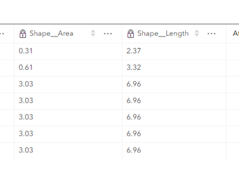
The following is the features and their areas in AGOL.
The below is the same features but after they have gone through the replica creation process, I linked above.
Thanks.
- Mark as New
- Bookmark
- Subscribe
- Mute
- Subscribe to RSS Feed
- Permalink
rows are offset by one but the lengths are the same and the areas are the same, hence the ring orientations appear to differ by whatever ST-whatever uses vs Pro
... sort of retired...
- Mark as New
- Bookmark
- Subscribe
- Mute
- Subscribe to RSS Feed
- Permalink
The following photo is directly from AGOL. It does not show the st_area.
Is there a reason AGOL is changing the field to st_whatever? The data initially started out in a GDB. Published the data in that gdb to AGOL. No edits were made to polygon shape while the data was in AGOL, and then using the ESRI workflow above, turned it back into a GDB. Trying to understand why or where this is occurring or if it is a bug. Thanks!


