- Home
- :
- All Communities
- :
- Products
- :
- ArcGIS Pro
- :
- ArcGIS Pro Questions
- :
- Legend range instead of less than equals to
- Subscribe to RSS Feed
- Mark Topic as New
- Mark Topic as Read
- Float this Topic for Current User
- Bookmark
- Subscribe
- Mute
- Printer Friendly Page
Legend range instead of less than equals to
- Mark as New
- Bookmark
- Subscribe
- Mute
- Subscribe to RSS Feed
- Permalink
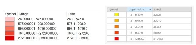
When creating graduated color legends in ArcGIS Pro, other than manually formatting value ranges under the symbology legend label, is there any way of automatically showing the full numeric value range in the legend rather than the less than or equal to upper value range? This is automatic in ArcMap as well as ArcGIS Online. Not having this capability adds unnecessary time especially for those that do a good deal of thematic mapping.
- Mark as New
- Bookmark
- Subscribe
- Mute
- Subscribe to RSS Feed
- Permalink
Manual edits to the label are needed in both.
- Mark as New
- Bookmark
- Subscribe
- Mute
- Subscribe to RSS Feed
- Permalink
By default the ArcMap legend for a graduated color displays the actual range within each class. ArcGIS Pro by default displays a single value with less than sign. Is there a setting to show the actual range within ArcGIS Pro?
- Mark as New
- Bookmark
- Subscribe
- Mute
- Subscribe to RSS Feed
- Permalink
hmmm mine shows <= in ArcMap ... which suggests that there is a toggle in ArcMap somewhere
- Mark as New
- Bookmark
- Subscribe
- Mute
- Subscribe to RSS Feed
- Permalink
I've used ArcMap for years, but just started using ArcGIS Pro. I don't understand the reasoning behind the default Pro choropleth legend. Although the Label may be correct for the entire set of values, it's incorrect for the individual patch Symbol next to the Label. Looking at Jay's display above, the patch to the left of <= 3916, doesn't include anything <= 2623, so the Label <=3916 is incorrect. I'd really like the option to use a range of values for each patch.
- Mark as New
- Bookmark
- Subscribe
- Mute
- Subscribe to RSS Feed
- Permalink
albeit not the norm... it implies the upper limit of the range... the implied part is that the previous number is the lower limit.... so technically everyone is correct ... except for the vast majority of people that haven't noticed the range expression differences but are mesmerized by the colors 
- Mark as New
- Bookmark
- Subscribe
- Mute
- Subscribe to RSS Feed
- Permalink
Because the patches are separated by a space, I don't believe the implied limits are clear. The upper and lower range values should be explicitly stated for this type of patch legend. As is, the legend is confusing and technically incorrect. Unfortunately, it doesn't seem there are any other options, so I'll be using ArcMap for my traditional choropleth maps for the time being.
- Mark as New
- Bookmark
- Subscribe
- Mute
- Subscribe to RSS Feed
- Permalink
Thank you for the feedback. We've heard this from others as well. We made the change in Pro because the legend classes in ArcMap can be misleading and do not reflect the true break edges. That said, I understand that there's a desire to see whole classes. We will look at rectifying both issues in a future release.
- Mark as New
- Bookmark
- Subscribe
- Mute
- Subscribe to RSS Feed
- Permalink
I agree with the OP. The folks who want my maps just do not understand the use of the LT/ET nomenclature.
- Mark as New
- Bookmark
- Subscribe
- Mute
- Subscribe to RSS Feed
- Permalink
An idea about improving the legend class breaks is here to vote on.