- Home
- :
- All Communities
- :
- Products
- :
- ArcGIS Pro
- :
- ArcGIS Pro Questions
- :
- Re: Legend Label Changed From ≤ to <=.
- Subscribe to RSS Feed
- Mark Topic as New
- Mark Topic as Read
- Float this Topic for Current User
- Bookmark
- Subscribe
- Mute
- Printer Friendly Page
Legend Label Changed From ≤ to <=.
- Mark as New
- Bookmark
- Subscribe
- Mute
- Subscribe to RSS Feed
- Permalink
I am using ArcGIS Pro 2.4.1. When I use the symbology properties to "Classify" my floating point raster with the "Quantile" method, the label changes from being a single ≤ symbol to two symbols <= ...after reducing the format of the labels to round to 1 decimal place. This seems like a bug. I believe that my only solution is to go back and manually edit these back to the single symbol of ≤.
From:
To:

Any advice would be welcome. I now have about 300 layers to manually correct.
Thanks,
Roland
- Mark as New
- Bookmark
- Subscribe
- Mute
- Subscribe to RSS Feed
- Permalink
Hi Roland,
A couple of us over here have taken a look at this in ArcGIS Pro 2.4.1 and we aren't able to reproduce what you're seeing.
I'd recommend opening a case with technical support to troubleshoot further as this isn't a straightforward issue to reproduce.
Thank you.
- Mark as New
- Bookmark
- Subscribe
- Mute
- Subscribe to RSS Feed
- Permalink
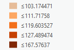
2.4.2 is still doing this... Within the legend... If you go under "Advanced Symbol Option", Format Labels... and "Rounding" to 2 decimal places... you will see this. I see that it occurs with Quantile methods as well:


Thanks,
Roland
- Mark as New
- Bookmark
- Subscribe
- Mute
- Subscribe to RSS Feed
- Permalink
This has been filed under an Esri Bug number and it is owned by the raster team. I will report back if there is a solution.
- Mark as New
- Bookmark
- Subscribe
- Mute
- Subscribe to RSS Feed
- Permalink
I understand that this bug has been fixed in the latest release.