- Home
- :
- All Communities
- :
- Products
- :
- ArcGIS Pro
- :
- ArcGIS Pro Questions
- :
- Labels Behind Feature Classes
- Subscribe to RSS Feed
- Mark Topic as New
- Mark Topic as Read
- Float this Topic for Current User
- Bookmark
- Subscribe
- Mute
- Printer Friendly Page
Labels Behind Feature Classes
- Mark as New
- Bookmark
- Subscribe
- Mute
- Subscribe to RSS Feed
- Permalink
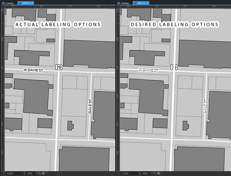
I have been working on creating a custom basemap and I have run into an issue which I think is peculiar. Why is there not an option (or I cannot find the option) to put labels behind feature classes? I know this may not be ascetically pleasing, but I really want this option with actual labels and not converted graphics. I would like to preserve the quality of the text vectors. This would be really useful when I have a lot of features on the map and the road labels are covering them and all I am wanting with the road names is a general sense of the location. Am I missing something and this can be done somehow or is this a really crazy pointless idea?
- Mark as New
- Bookmark
- Subscribe
- Mute
- Subscribe to RSS Feed
- Permalink
Hi Charles,
Not sure how you made that second map (meaning maybe you've already done what I'm going to suggest), but the only thing I can think of would be to convert your labels to annotation and then have the anno draw underneath the features.
What you describe as the reason for doing this seems odd to me. It sounds like things are getting "cluttered" and unreadable in your map... I would think that a better option would be to thin out your labels (or even features) at certain scales to keep things clean.
You could build different label classes based on the category of streets you're working with:
Label classes—ArcGIS Pro | ArcGIS Desktop This doc also talks about setting scale ranges for the classes.
Another really good thing to look at would be Author a multiscale map—ArcGIS Pro | ArcGIS Desktop
Hope this helps!
- Mark as New
- Bookmark
- Subscribe
- Mute
- Subscribe to RSS Feed
- Permalink
Hey Kory,
I really want to avoid having to convert the labels to graphics or annotations (I created the above image in Photoshop). I think what I am wanting to do is not possible. Also the idea may seem strange to some that I would want to be able to do this with labels however, I think it is something that makes sense and should be a simple checkbox option. It is odd that the option to do this has never been developed if even for just a little more flexibility. While I do have a lot of features on the map and at times they do get cluttered (there is just no way around that) the main point of this would be to preserve the vector quality of the label with zooming and panning while not obstructing the more important features I need displayed. I have already developed complex labeling rules with VBA and SQL for displaying specific features and I have the scaling rules as well. I pretty much have everything else is exactly how I'd like to display the map. It seems like I may have to use what you suggested with the annotations. Thanks for the reply!
- Mark as New
- Bookmark
- Subscribe
- Mute
- Subscribe to RSS Feed
- Permalink
Thanks, Charles.
I do think that you will need to work with annotations and treat them as a layer so that they draw beneath other features.
I found this idea: https://community.esri.com/ideas/11484. Which is great because it is exactly what you're looking for!!! BUT what isn't great is that it is from 2 years ago and nobody from the user community has voted for it, meaning that it is unlikely to get any attention from the development team.
I'd say go with annotation for now.
- Mark as New
- Bookmark
- Subscribe
- Mute
- Subscribe to RSS Feed
- Permalink
Kory!
I just stumbled across that same post a few minutes ago and was about to post it here as well! It is a shame it has not gone anywhere in the past two years! Hopefully the developers will see the value in adding such a feature sometime very soon!
I appreciate the help again!
- Mark as New
- Bookmark
- Subscribe
- Mute
- Subscribe to RSS Feed
- Permalink
To be honest, even as a fellow ESRI product user, I think the chances of this getting real traction with ESRI's dev team are low.
As you yourself noted, this is a really rare corner case for labelling. I also think it isn't particularily good cartography, but I don't think I have to really tell you that, because you already know.
However, as to the particular problem you seem to try to solve:
"to preserve the vector quality of the label with zooming and panning while not obstructing the more important features I need displayed."
I would think it is actually far more logical to significantly reduce the width of your (white) text halos, or drop them altogether. Your current text halo widths are pretty huge.
With no halos, the roads and road continuity, and potentially other features in your map, will be much more visible, as the roads will display between and behind the individual characters of your labels. Yes, the readability of the text will slightly suffer in some cases (although it heavily depends on the particular cartography and color contrast, it may in fact improve in some cases as well).
I think this is a much more logical and elegant solution to the same problem, that doesn't produce poor cartography, nor requires annotation or specific stacking of layers.
- Mark as New
- Bookmark
- Subscribe
- Mute
- Subscribe to RSS Feed
- Permalink
You may also find this ESRI vector basemap design "Story Map" regarding labelling useful. It mentions similar issues, and how ESRI cartographers deal with it in vector basemaps:
- Mark as New
- Bookmark
- Subscribe
- Mute
- Subscribe to RSS Feed
- Permalink
One Another way would be to Set Labels as Background Labels (using Maplex Label Engine). Check if it suits your requirement.
Think Location
- Mark as New
- Bookmark
- Subscribe
- Mute
- Subscribe to RSS Feed
- Permalink
Jayanta Poddar This is for placement of labels behind other labels, not behind features. I read through that doc and subsequently toyed with the setting just to see if it would do the job, but it doesn't. Notice in the example in the doc:
In the image below, the label for the Isle of Wight is set as a background label. You can see that the city and road labels treat it as empty space and appear on top of the label.
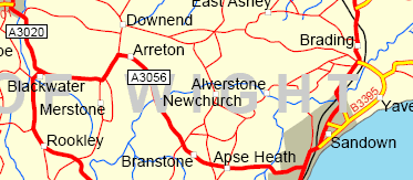
What the doc doesn't explicitly say is - also notice that the Isle of Wight label still draws on top of all features 
- Mark as New
- Bookmark
- Subscribe
- Mute
- Subscribe to RSS Feed
- Permalink
Hmmm... You are right. I just checked it on ArcMap. Maybe working with Annotations would be the only solution (as per Charles' requirement).
- Convert Labels to Annotation
- Drag the Annotation Layer below the Feature Layer (Drawing Order) in Contents pane.
Think Location