Turn on suggestions
Auto-suggest helps you quickly narrow down your search results by suggesting possible matches as you type.
Cancel
- Home
- :
- All Communities
- :
- Products
- :
- ArcGIS Pro
- :
- ArcGIS Pro Questions
- :
- Re: Importing Contours
Options
- Subscribe to RSS Feed
- Mark Topic as New
- Mark Topic as Read
- Float this Topic for Current User
- Bookmark
- Subscribe
- Mute
- Printer Friendly Page
03-26-2022
08:55 AM
- Mark as New
- Bookmark
- Subscribe
- Mute
- Subscribe to RSS Feed
- Permalink
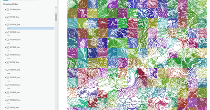
Hi - I have added the Ordnance Survey Terrain 5 Contours Shapefiles to my project. And yet, as you can see in the attached image I have different colours per tile. Is there a way to import in standard format i.e. without different colours per tile.
thanks!
Solved! Go to Solution.
1 Solution
Accepted Solutions
03-26-2022
12:17 PM
- Mark as New
- Bookmark
- Subscribe
- Mute
- Subscribe to RSS Feed
- Permalink
This site talks about this. The Apply Symbology From Layer geoprocessing tool would work.
Also in the symbology pane for each layer you can import symbology from a layer file.
2 Replies
03-26-2022
12:17 PM
- Mark as New
- Bookmark
- Subscribe
- Mute
- Subscribe to RSS Feed
- Permalink
This site talks about this. The Apply Symbology From Layer geoprocessing tool would work.
Also in the symbology pane for each layer you can import symbology from a layer file.
03-27-2022
10:47 AM
- Mark as New
- Bookmark
- Subscribe
- Mute
- Subscribe to RSS Feed
- Permalink
Thank you !