- Home
- :
- All Communities
- :
- Products
- :
- ArcGIS Pro
- :
- ArcGIS Pro Questions
- :
- Re: Custom Projection in ArcGIS Pro
- Subscribe to RSS Feed
- Mark Topic as New
- Mark Topic as Read
- Float this Topic for Current User
- Bookmark
- Subscribe
- Mute
- Printer Friendly Page
- Mark as New
- Bookmark
- Subscribe
- Mute
- Subscribe to RSS Feed
- Permalink
I have created a custom projection in ArcGIS Pro 2.4.2 (NAD 1983 UTM Zone 11N - Foot US), but ArcGIS Pro seems to handle the projection different than ArcGIS Desktop. When I create a new custom projection in ArcGIS Desktop and change the Linear Unit, the False Easting value is automatically calculated. But, when I do the same process in ArcGIS Pro, the False Easting value is not auto-calculated and remains at the default linear unit value of the original projection.
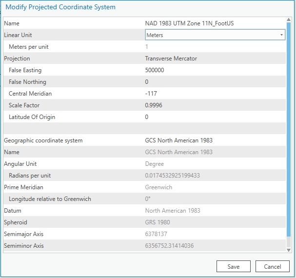
Process in ArcGIS Pro
Before changing Linear Unit:
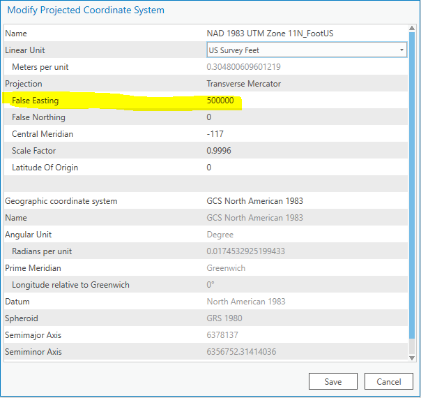
After changing Linear Unit:
Process in ArcGIS Desktop
Before changing Linear Unit:

After changing Linear Unit:
Notice the False_Easting value has changed!

Is this typical behavior? Does the user have to determine a False Easting value for every custom projection? This is causing data to plot incorrectly when importing the data into ArcGIS Pro.
Solved! Go to Solution.
Accepted Solutions
- Mark as New
- Bookmark
- Subscribe
- Mute
- Subscribe to RSS Feed
- Permalink
Hi Mitch,
Unfortunately, you have found a bug. Fortunately, this issue (tracked here) has been fixed in Pro 2.5, so you should not see it once this new version is released and you have upgraded.
- Mark as New
- Bookmark
- Subscribe
- Mute
- Subscribe to RSS Feed
- Permalink
Thanks, Dan. I was just wondering why the user now has to do this conversion and manually input the value in instead of the software. This could/will lead to an incorrect data entry. It's just strange that the function is found in ArcGIS Desktop and not ArcGIS Pro.
- Mark as New
- Bookmark
- Subscribe
- Mute
- Subscribe to RSS Feed
- Permalink
Sound like ArcGIS Ideas … probably due to web stuff
- Mark as New
- Bookmark
- Subscribe
- Mute
- Subscribe to RSS Feed
- Permalink
Hi Mitch,
Unfortunately, you have found a bug. Fortunately, this issue (tracked here) has been fixed in Pro 2.5, so you should not see it once this new version is released and you have upgraded.