- Home
- :
- All Communities
- :
- Products
- :
- ArcGIS Pro
- :
- ArcGIS Pro Questions
- :
- Creating new shp file by drawing polygons
- Subscribe to RSS Feed
- Mark Topic as New
- Mark Topic as Read
- Float this Topic for Current User
- Bookmark
- Subscribe
- Mute
- Printer Friendly Page
- Mark as New
- Bookmark
- Subscribe
- Mute
- Subscribe to RSS Feed
- Permalink
Hello again with another newbie question 
I have the point shp file as shown in the attachment, but I need it to a polygon shp file with each polygon having the area calculated. I was thinking of drawing the polygons in another layer and exporting that layer as a shp file. Is that the proper approach to this or is there another way? If so, how can you create a new empty layer and draw the polygons on it? ( I tried add data under the map tab but I am not seeing how to create a new empty layer and drawing the polygons on it)
Thanks again for the help
Solved! Go to Solution.
Accepted Solutions
- Mark as New
- Bookmark
- Subscribe
- Mute
- Subscribe to RSS Feed
- Permalink
To create a new, blank feature class: Open the Catalog. Right-click the workspace (folder or gdb) in which you want to make your new feature class. Choose New -> Shapefile (or Feature Class).
If you use a GDB feature class, it will create two new auto-populated fields, one for perimeter and one for area, so you don't have to calculate those.
I'm unclear whether you want to use your existing point geometry as polygon vertices, or start fresh.
- Mark as New
- Bookmark
- Subscribe
- Mute
- Subscribe to RSS Feed
- Permalink
If I could use the existing point geometry, that would be best. This is for ArcGIS Pro 1.1.1
- Mark as New
- Bookmark
- Subscribe
- Mute
- Subscribe to RSS Feed
- Permalink
Ah, my instructions are for ArcGIS Desktop. Sorry, I didn't register that your post had been filed in the correct place.
- Mark as New
- Bookmark
- Subscribe
- Mute
- Subscribe to RSS Feed
- Permalink
Other information is also included here
ArcGIS Pro ... useful transitioning links and images
it includes how to create shapefiles etc.
- Mark as New
- Bookmark
- Subscribe
- Mute
- Subscribe to RSS Feed
- Permalink
You posted this question in the ArcGIS Pro Space so I assume you are using ArcGIS Pro. When you have a project in ArcGIS Pro, you will also have a File Geodatabase to store your project data. You can right click on the File Geodatabase and select New, Featureclass:
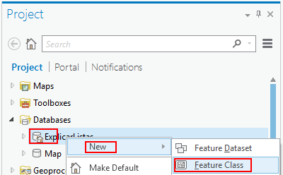
... but this will create a featureclass in a File Geodatabase and not the Shapefile format you are mentioning. To create a Shapefile you will have to execute the Create Feature Class—Data Management toolbox | ArcGIS for Desktop tool.
If you select a Folder as the Feature Class Location you will create a shapefile.
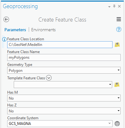
You will probably select "Current Map [Map]" as coordinate system or the coordinate system of your points for this featureclass.
Once you have created the featureclass and it is added to your map, you can start digitizing.
See: Open a map and start editing—ArcGIS Pro | ArcGIS for Desktop and Create polygon features—ArcGIS Pro | ArcGIS for Desktop for instructions.
The alternative is to convert the existing points to a polygon. For this you use Points To Line—Data Management toolbox | ArcGIS for Desktop followed by Feature To Polygon—Data Management toolbox | ArcGIS for Desktop
- Mark as New
- Bookmark
- Subscribe
- Mute
- Subscribe to RSS Feed
- Permalink
Yeah I believe I am 95% there. I was able to create the new feature, the polygon, the export that polygon out as shp files (Right click data->export feature)
It look likes the shape_area record is in square feet? (based off the default). I was hoping to have it record in hectares. I changed the default unit measurement to hectares in the options under project -> units. I also checked the layer properties but did not see anything. What would be the way to set the default units?
Thanks for the awesome support by the way everyone.
- Mark as New
- Bookmark
- Subscribe
- Mute
- Subscribe to RSS Feed
- Permalink
Hi. Just a quick followup regarding the units the shape_area is recorded in. Where would I change the unit used for the measurement (I tried the project settings but had no luck
Thanks again
- Mark as New
- Bookmark
- Subscribe
- Mute
- Subscribe to RSS Feed
- Permalink
the units are in the units of the data, if in meters, m^2 would be area... ft to ft^2. There are a variety of ways to do that. Preferably, one should calculate a new field, appropriately labelled, to reflect units in a different measure.
Fundamentals of field calculations—Help | ArcGIS for Desktop
- Mark as New
- Bookmark
- Subscribe
- Mute
- Subscribe to RSS Feed
- Permalink
OK make sense.
Would my assumption for drawing a polygon units be measured square feet or how would I tell what unit its measured in? (The shape_area field)?
Thanks as always