- Home
- :
- All Communities
- :
- Products
- :
- ArcGIS Pro
- :
- ArcGIS Pro Questions
- :
- Re: Clip layers to shape extent ArcGIS Pro
- Subscribe to RSS Feed
- Mark Topic as New
- Mark Topic as Read
- Float this Topic for Current User
- Bookmark
- Subscribe
- Mute
- Printer Friendly Page
- Mark as New
- Bookmark
- Subscribe
- Mute
- Subscribe to RSS Feed
- Permalink
Has anyone had experience clipping layers to the extent of a shape in ArcGIS Pro?
It works perfectly on Desktop but in Pro it will only clip to the extent of the layer, not the shape. This gives a square, rather than the shape I want.
Is there an option somwhere that I haven't found yet?
Solved! Go to Solution.
- Mark as New
- Bookmark
- Subscribe
- Mute
- Subscribe to RSS Feed
- Permalink
Do you know a way to make a masking layer do what we're asking here? The example that you refer to is different from what's being discussed.
- Mark as New
- Bookmark
- Subscribe
- Mute
- Subscribe to RSS Feed
- Permalink
I installed pro to get around a bug in ArcMap relating to the export of clipped data frames. Now I find the feature I want is completely absent in pro. Irregular map extents are very useful for displaying spatial information alongside text and graphs. It would be very helpful if some priority was given to sorting this out.
- Mark as New
- Bookmark
- Subscribe
- Mute
- Subscribe to RSS Feed
- Permalink
It's been nearly three years. Is this going to be added? Arcgis Pro
- Mark as New
- Bookmark
- Subscribe
- Mute
- Subscribe to RSS Feed
- Permalink
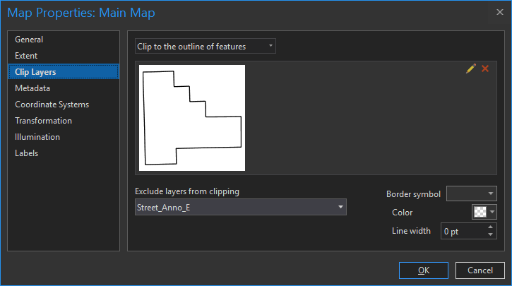
You can Clip Layers in ArcPro just like in ArcMap. But I think it's even enhanced as I don't remember a dropdown that can exclude layers from being clipped-- pretty nice.
All you do is left click the map frame on the Layout tab --> Properties --> Clip Layers
- Mark as New
- Bookmark
- Subscribe
- Mute
- Subscribe to RSS Feed
- Permalink
Following this method, my clip is honored in both the Map and Layout windows. However, when I export the layout, the clip is no longer honored. How can I get the clip to remain in the exported PDF?
- Mark as New
- Bookmark
- Subscribe
- Mute
- Subscribe to RSS Feed
- Permalink
Aaron,
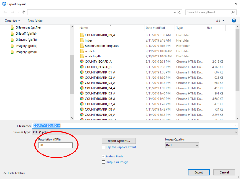
What comes to mind is something with the graphics. When you share/export the layout is your resolution set too low?
I keep mine at 300 dpi.
- Mark as New
- Bookmark
- Subscribe
- Mute
- Subscribe to RSS Feed
- Permalink
Kory Kramer, is the problem that Aaron reports above a bug? He says he loses the clip-to-shape when he exports to a PDF.
- Mark as New
- Bookmark
- Subscribe
- Mute
- Subscribe to RSS Feed
- Permalink
Exporting the layout or exporting the map?
I don't think map clipping is honored in the layout until 2.4. Can you confirm what happens if you export the map with clipping?
- Mark as New
- Bookmark
- Subscribe
- Mute
- Subscribe to RSS Feed
- Permalink
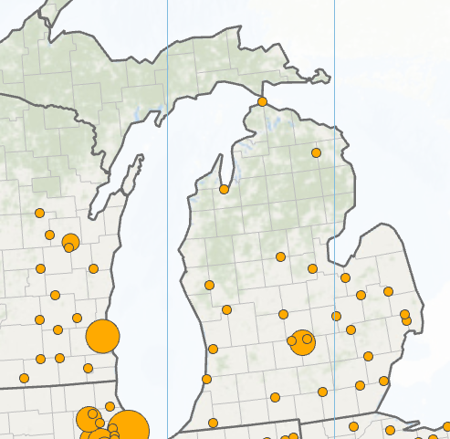
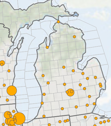
I'm using ArcGIS Pro 2.3.3 and I still encounter the error in which the clipping is not honored in the export. In the following example, the US state boundaries are clipping the county boundaries. The image on the left is from ArcGIS Pro (showing the clip) and the image on the right is from the export (not showing the clip). So is 2.4 supposed to fix this discrepancy? Thanks for any info you can provide!