- Home
- :
- All Communities
- :
- Products
- :
- ArcGIS Pro
- :
- ArcGIS Pro Questions
- :
- Calculated feature area versus geodatabase provide...
- Subscribe to RSS Feed
- Mark Topic as New
- Mark Topic as Read
- Float this Topic for Current User
- Bookmark
- Subscribe
- Mute
- Printer Friendly Page
Calculated feature area versus geodatabase provided area?
- Mark as New
- Bookmark
- Subscribe
- Mute
- Subscribe to RSS Feed
- Permalink
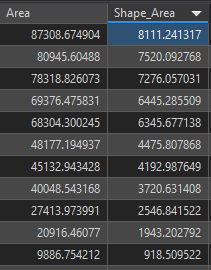
I have a feature class using a projected coordinate reference system (a State Plane system in the U.S.) that is housed in a file geodatabase. When I use "Calculate Geometry" on a static field I have created, I get different values than those values that are provided by the geodatabase in the standard "Shape_Area" field. This ONLY happens, however, if I specify the coordinate system to be used during the calculation. If I leave that option blank, and it defaults to the coordinate system of the feature class, the values in the two columns are the same.
I am using a fresh map with no other datasets, ArcGIS Pro 2.6.0. The coordinate system of the Map matches that of the feature class, a State Plane system. Since there are no other datasets, transformations are not involved. These features are small enough that there should be essentially no differences between geodesic and planar values, at least not of this magnitude. When I use the option to specify the coordinate system, I am in fact specifying the same one used by the feature class (I realize this is redundant, since it will default to this anyway, but less experienced users might not know this). I am not accidentally choosing a coordinate system with a linear unit of meters when the dataset is using feet, for example.
It also seems to work fine if I choose the "Area" property as normal, skip over the units drop down, and then specify the coordinate system. Basically, the discrepancy seems to arise if I specify both a unit AND and coordinate system. Anyone else experiencing this issue or have an idea of what could be going on here?