- Home
- :
- All Communities
- :
- Products
- :
- ArcGIS Pro
- :
- ArcGIS Pro Questions
- :
- Re: ArcGIS Pro local scene elevation units
- Subscribe to RSS Feed
- Mark Topic as New
- Mark Topic as Read
- Float this Topic for Current User
- Bookmark
- Subscribe
- Mute
- Printer Friendly Page
ArcGIS Pro local scene elevation units
- Mark as New
- Bookmark
- Subscribe
- Mute
- Subscribe to RSS Feed
- Permalink
I noticed that I cannot change the vertical elevation units of any Elevation Surface? Is there a reason for this being locked out? All of my elevation data is in feet, yet Pro is converting it to Meters, so my surfaces are worthless and all my data is thousands of feet in the air. Is there a way to get my vertical units in feet? I am using a local scene and a horizontal coordinate system of NAD 83 State Plane (US Feet).... My custom TIN was created in CAD using this same coordinate system.
- Mark as New
- Bookmark
- Subscribe
- Mute
- Subscribe to RSS Feed
- Permalink
perhaps this?
Define height characteristics for layers—ArcGIS Pro | ArcGIS for Desktop
or
Elevation surfaces—Properties of maps | ArcGIS for Desktop
vertical exaggeration is keyword. meters - feet 0.3048 m/ft
- Mark as New
- Bookmark
- Subscribe
- Mute
- Subscribe to RSS Feed
- Permalink
Thanks Dan,
I think a lot of this surface elevation stuff is just going over my head. (no pun intended)
When I replace the Ground surface with a custom TIN, why are the elevation units shown as Meters? Is that just how it is?
If I know a pump motor sits at 750 ft above sea level, why can't I just set the z-value to 750 and be done? It changes it to 220 something....
I don't think the vertical exaggeration is changing anything for me. nothing appears to change when I apply it.
- Mark as New
- Bookmark
- Subscribe
- Mute
- Subscribe to RSS Feed
- Permalink
You have to confirm what you units are actually in. Originating in the U.S. no longer implies a default of units in feet. Also, just because a dialog shows one set of units, it doesn't mean it is...it is guessing, so tell it what it is, assuming that is known. So perhaps the data are in one set of units and you are telling it (aka, wanting it) to be in another. Clarify that first in order to make some certain progress.
- Mark as New
- Bookmark
- Subscribe
- Mute
- Subscribe to RSS Feed
- Permalink
I think I'm hung up on why I can't change the vertical units of my surface in Pro. It says Meters, but it is greyed out so I can't change it. Maybe that unit is a non-factor though, I don't know. My surface is in feet, my z-values were in feet until Pro changed them to meters (I guess?). I'm at the extent of my knowledge on this type of stuff to try anything else, but I really appreciate the input.
- Mark as New
- Bookmark
- Subscribe
- Mute
- Subscribe to RSS Feed
- Permalink
can you record, screen grab the data layer's properties (right-click, select properties) and examine the tabs, relating to extents, coordinate systems etc
- Mark as New
- Bookmark
- Subscribe
- Mute
- Subscribe to RSS Feed
- Permalink


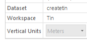
Here is one feature:
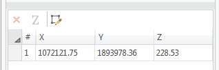
It would be ideal to enter in the Z as feet off the asbuilt plans, which in this case is 745.75. When I override that value to be 745.75 this feature shoots up in elevation about 1200 feet. I know I have some setting wrong. I don't know what combination of things is right.
This is how my scene is setup:
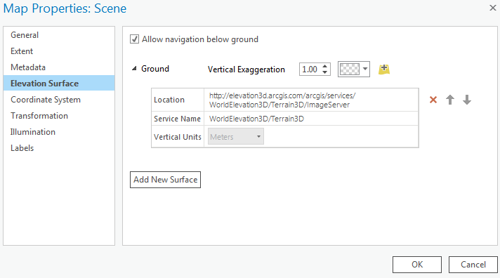
I did have a custom surface in there at one point, but it didn't seem to help, so it's back at the default ESRI surface.
Thanks
- Mark as New
- Bookmark
- Subscribe
- Mute
- Subscribe to RSS Feed
- Permalink
I suspect the image server is in meters and your sample elevation looks like it is meters also. One thing you haven't tried (perhaps), is to start a new project...clean...just add your data...nothing else, see what you have, then what happens when you add the server data
- Mark as New
- Bookmark
- Subscribe
- Mute
- Subscribe to RSS Feed
- Permalink
Dan,
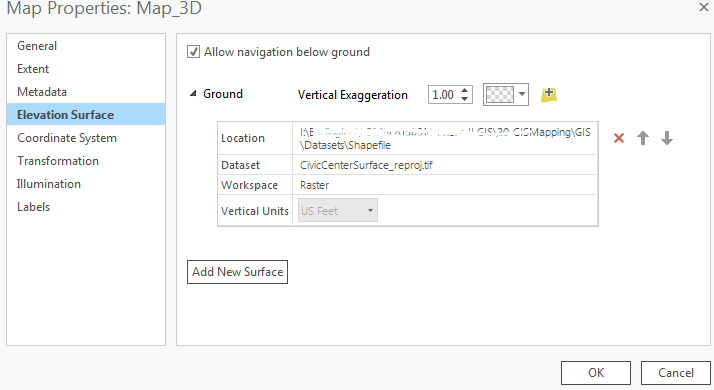
This was a great idea, and just what I needed to fix almost everything. I opened up my raster file that I was using as a custom surface and found out there was no spatial reference. The projected raster had been moved to a temp folder, so that's embarrassing...
Using the GOOD raster this time I did bring it into an empty workspace and I now have a ground surface in feet!
The only situation I have left to figure out, and this is still part of my original problem, is why its still showing my Z-values in meters. This is strange to me because when I open these layers up in any other blank map, the vertices are shown in feet for the Z. For example; in the same Pro project I created a basemap tab and added one of these layers and the z-values read feet. But in my local scene, it's meters. I'm baffled, but about ready to just let it be since it's not actually changing the data values in the database. Let me know if you have any other thoughts, and thanks again!
- Mark as New
- Bookmark
- Subscribe
- Mute
- Subscribe to RSS Feed
- Permalink
I am still not convinced that it just isn't just what Pro shows by default...do the values change when you switch?