- Home
- :
- All Communities
- :
- Products
- :
- ArcGIS Pro
- :
- ArcGIS Pro Questions
- :
- ArcGIS Pro 2.2 | Best configuration ?
- Subscribe to RSS Feed
- Mark Topic as New
- Mark Topic as Read
- Float this Topic for Current User
- Bookmark
- Subscribe
- Mute
- Printer Friendly Page
ArcGIS Pro 2.2 | Best configuration ?
- Mark as New
- Bookmark
- Subscribe
- Mute
- Subscribe to RSS Feed
- Permalink
Hi,
I was running ArcGIS Pro 2.2 with this config:


And I have now this:

I did notice some improvment in terms of speed while editing labels, but it is not the very best either. Fairly disappointed even. It looks like there is only 16Gb extra RAM on my new config, but not much more...
Is there any bottleneck in this configuration? Is the Graphic card good enough? What hardware configuration would ESRI recommend to improve overall performance?
I did use the detection tool provided by ESRI to benchmark my configuration:
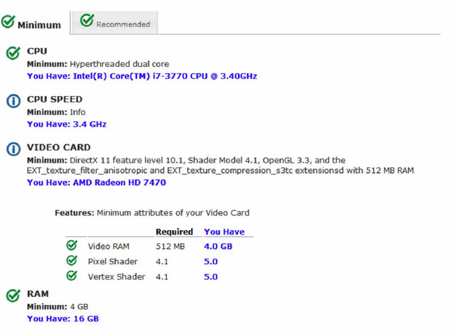
It looks like the CPU speed could be faster and the video card better... Any suggestion on this?
Thanks
- Mark as New
- Bookmark
- Subscribe
- Mute
- Subscribe to RSS Feed
- Permalink
To work around, I had to:
- Turn off all of the AGOL layers, including the world imagery
- Hunt for, and download to my laptop, a local roads vector layer: I needed some sort of reference so I could zoom and pan to my new AOI in the new layout while in map activated mode
- Turned the AGOL layers back on and removed the local vector layer
- This took an hour of my life, that I'll never get back, to figure out how to keep going on this project. There is a delivery-on-time requirement......
This is not a solution though: This project will be used by multiple folks in many, very distant geographic locations and I specifically set it up so the maps and layouts we need are pulling from AGOL HFS's, so they'll work anywhere. This is with the default cache settings, and yes, I've cleared cache, I've moved the cache folder, I've rebooted, the drivers are current.
I get that one has to wait a minute or two for AGOL data to sort itself out over a 7MB internet connection. However, 10 minutes of the thermal vents baking the varnish off my kitchen table is not how GIS software should respond when I zoom and pan to a AGOL HFS.
I suspect, that based on a previous case, the size of the APRX file (12+MB) and the number of layouts using multiple map grids in each layout, is a contributor (but not the cause) to this issue. Multiple maps and layouts in a project is cool, but you should open up that APRX file and look at the quantity and size of the xml files being generated.
Speaking of using AGOL in the classroom: If you have 50 kids all hit the same HFS, and it has features with a lot of vertices...better make sure your lab PC's have Solitaire installed on them. Where possible, use Vector Tiles, but that doesn't help you if you're teaching how to use the ID or Select by Attributes Tool. Quoting you, I believe, make use of the Simplify Tool if it's just training data.....
- Mark as New
- Bookmark
- Subscribe
- Mute
- Subscribe to RSS Feed
- Permalink
Locally stored... it will be 
- Mark as New
- Bookmark
- Subscribe
- Mute
- Subscribe to RSS Feed
- Permalink
I got the same question from my customer on providing the best workstation that they would use for ArcGIS Pro 2.2.
Summing all above up, what would you recommend from workstation specs standpoint? Proc, RAM, GPU, network bandwidth?
Does anybody deal with vGPU?
- Mark as New
- Bookmark
- Subscribe
- Mute
- Subscribe to RSS Feed
- Permalink
Curious as to why you're scoping for ArcGIS Pro 2.2?
Anyways, even though Pro 2.2 is supported until 2021 (https://support.esri.com/en/Products/Desktop/arcgis-desktop/arcgis-pro/2-4#product-support) you should look at the current system requirements for Pro 2.4.
There is a good thread here: https://community.esri.com/message/847967-arcgis-pro-on-a-dell-xps-13-will-i-regret-it
And I remember Thomas Colson posting some very detailed specs, but can't seem to find that now...
- « Previous
-
- 1
- 2
- Next »
- « Previous
-
- 1
- 2
- Next »