- Home
- :
- All Communities
- :
- Products
- :
- ArcGIS Pro
- :
- ArcGIS Pro Ideas
- :
- Show field level metadata from the attribute table
- Subscribe to RSS Feed
- Mark as New
- Mark as Read
- Bookmark
- Follow this Idea
- Printer Friendly Page
Show field level metadata from the attribute table
- Mark as New
- Bookmark
- Subscribe
- Mute
- Subscribe to RSS Feed
- Permalink
It would be great if it was possible to right click on a field heading in the attribute table and choose an option to show just the field level metadata for that particular field (if available) from the metadata. That way if it is unclear what a field heading means or if the data in the field needs explaination and this explaination is held as field level metadata this can be easily and quickly seen without having to open the metadata and scroll wayyy down to the bottom to find it.
- « Previous
-
- 1
- 2
- Next »
I had an Idea when creating a new layer for a co-worker who didn't use GIS. I had spoken to them about creating and using GIS data and how adding a spatial element would allow them to interact with their databases and analyse in a new, potentially easier way of managing their data. I delved into the usual speil that all GIS users have undertaken when trying to turn the uninitiated to the cause.
So when explaining the concept of BLOB and raster fields in a feature layer and how you can add documents and images to a feature layer, I showed them how to create this field and I when i was explaining he difference of the field name and the alias to them. They said "so will that show you the type of data to input or guide the user as to what to put into the field? I was a little confused so they tried to explain. "You know like, in excel when you write a comment in a box and the small red triangle appears in the corner and when you hover over the comment it appears with whatever you wrote, can you do that to the field headings to make sure the user only attaches the correct document to the record, or what type of data or input relevant comments into the table, like a way to remind them where data should be coming from or how it should be formatted?
When I stopped to think about it I think it would be really useful if you could hover over the Field title and if you wanted a little information to help remind you of the data or where it had come from how it was input or where it was from, would be an interesting feature. helping users with limited GIS knowledge who only would be using the software for inputting data in their use of the software.
Unless I'm mistaken I don't believe there is a function like this available in Desktop. that when you run over the field headings you can get a breakdown of the data held in that column?
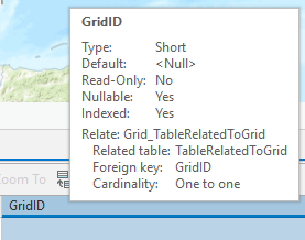
Andrew Boyd If I understand the request correctly, I believe it is already offered in ArcGIS Pro. ArcMap tables do not do this, but in ArcGIS Pro, you can hover over field headers and see the field's metadata. Here I hover over my GridID field and see the following:
Haven't checked out ArcGIS pro just yet, Its sort of what I meant but not quite, That abit in the technical side it was more along the lines of small comments like "data derived from....(source).." or "contents calculated by adding fields X & Y"
OK, thanks for the clarification.
Yes! metadata and data are too widely separated. Opening up an "item description" takes a long time and when you get there, it's the full record and a separate window. There should be quickly accessed context-menu / hover tips / popups, for example, that describe the field and the data as described in the metadata.
edit: What is this, how you say, "ArcMap"? I suppose my ArcGIS Pro Idea is related to this thread, but I don't see how it fits here in mid-2022.
original:
Open a table > right-click a field that interests me > View Field Metadata > opens the metadata at that field tag.


I fully agree - something like that last suggestion would be amazing, and including the field description in the hover text would be amazing. ArcGIS Pro is such a context sensitive application, and it would really round things out if metadata was part of what was exposed for each context.
This would be extremely useful to be able to document our data within the Enterprise Geodatabase, so that if a service were to be republished, we don't lose the attributes or have to recreate them.
You must be a registered user to add a comment. If you've already registered, sign in. Otherwise, register and sign in.