- Home
- :
- All Communities
- :
- Products
- :
- ArcGIS Pro
- :
- ArcGIS Pro Ideas
- :
- Map Series View Extent based on related features
- Subscribe to RSS Feed
- Mark as New
- Mark as Read
- Bookmark
- Follow this Idea
- Printer Friendly Page
- Mark as New
- Bookmark
- Subscribe
- Mute
- Subscribe to RSS Feed
- Permalink
I'd love to see related features be taken into account for view extents in ArcGIS Pro's Map Series.
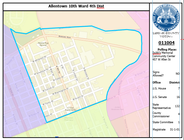
For example I built a map series for our Voting Precincts. They have related Polling Locations. The voting precinct is the index on which the map series relies. Sometimes the polling location is outside the boundaries of the precinct. Sometimes so much so that it doesn't show on the map.
If I change the extent %, it affects all maps in the series so in order to make sure they all show their polling places, I'd have to go through the whole series to find the farthest range and adjust the view extent. Then any precincts that contain the polling place within its boundaries will look unnecessarily small.
So, basically I'd like to see the maps series be able to automagically zoom to an extent that contains both the index feature and any related feature in the map.
It will keep maps like this from happening (the polling place would normally be a point on this map but it falls outside the extent):
Verry good idea
I believe this would also help my issue which is in the old MPS Atlas you could change the extent of the map frame based on the size of the index feature ie. a map index. This helps when your map index has different sized maps due to having 'special' sizes or when you are creating a map series for a whole country (AUS) when the size of your map increases the further away you get from the equator. eg. the map still covers 1 degree by 1.5 degrees but the size on paper is enlarged, therefore to show the whole map in your data frame it needs to enlarge.
You must be a registered user to add a comment. If you've already registered, sign in. Otherwise, register and sign in.