- Home
- :
- All Communities
- :
- Products
- :
- ArcGIS Pro
- :
- ArcGIS Pro Ideas
- :
- Give more information when hovering on a feature c...
- Subscribe to RSS Feed
- Mark as New
- Mark as Read
- Bookmark
- Follow this Idea
- Printer Friendly Page
Give more information when hovering on a feature class/shapefile
- Mark as New
- Bookmark
- Subscribe
- Mute
- Subscribe to RSS Feed
- Permalink
When hovering on a feature class only type and path are shown in the catalog pane.
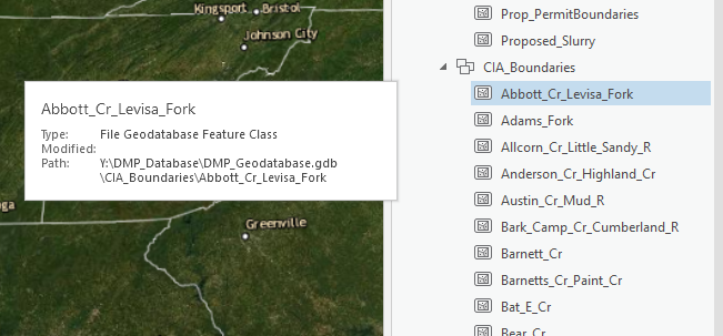
However, I would like to get more information without adding a feature class to Table of Contents (TOC). For example, I would like to be able to see a little description, feature count, fields and/or inset map etc. We have about 800 different feature classes. Sometimes I need to open 6-7 different feature classes till I found the right one. I am sure there is many GIS users dealing with vast amount of feature classes/shapefiles or layers. Seeing the content of the spatial data beforehand will help us to save time and energy.
If you can make this tooltip adjustable, it would be even better. In that way, a user can adjust the information s/he would like to see when mouse hover on spatial data.
Thanks!
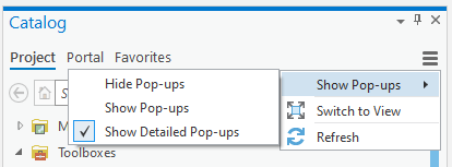
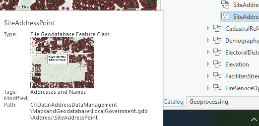
From the Catalog pane menu, if you click Show Detailed Pop-Ups, it will include the thumbnail and tags which hopefully will help:
That is discussed in this help topic: Use the catalog pane, catalog view, and browse dialog box—ArcGIS Pro | Documentation
As for showing more of a description, that idea is submitted as Catalog Pane Popup Window Needs to Include Summary It would be good for you to provide your support there as it sounds like you're requesting the same thing.
For much more detail than that, a better workflow might be to browse the data using the Catalog View rather than the Catalog pane, where you can see a full preview of the data and the metadata, and add a dataset to a new or open map once you've identified it.
While this option is not exactly what I would like to have, it will help me greatly. Thank you!
You must be a registered user to add a comment. If you've already registered, sign in. Otherwise, register and sign in.