- Home
- :
- All Communities
- :
- Products
- :
- ArcGIS Pro
- :
- ArcGIS Pro Ideas
- :
- Georeferencing Viewer Window in Pro
- Subscribe to RSS Feed
- Mark as New
- Mark as Read
- Bookmark
- Follow this Idea
- Printer Friendly Page
- Mark as New
- Bookmark
- Subscribe
- Mute
- Subscribe to RSS Feed
- Permalink
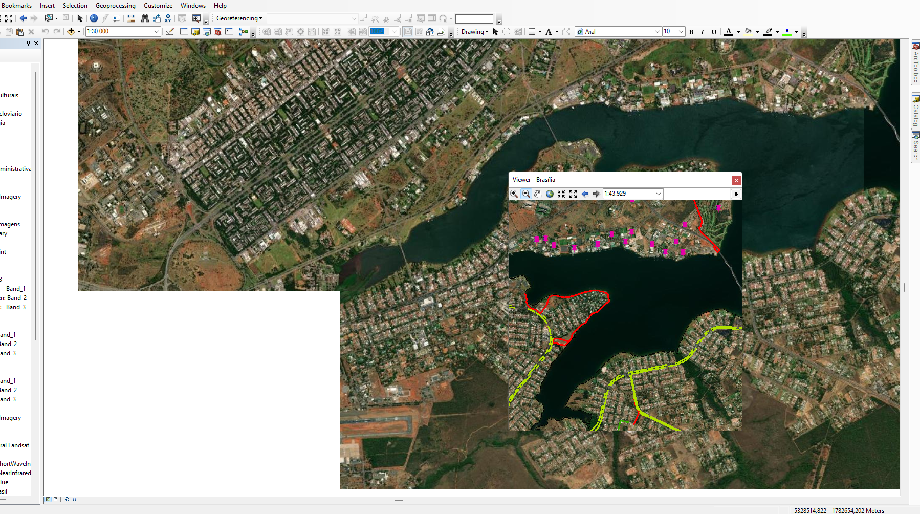
Pro needs a georeferencing viewer window like ArcMap has. I much prefer using the viewer to using fit to display.
- « Previous
-
- 1
- 2
- Next »
Omg, Yes.
This is driving me nuts!
Yes, yes, yes and yes please. put back the viewer window please, I can't believe such an handy tool has been left aside. I have to go back to QGIS to georeference maps now, which is much quicker and easier.
Thanks.
Hi! Could you please, please, please bring back the separate window viewer for georeferencing that existed in Map??? I do a LOT of georeferencing for my work, and it often involves matching up two land imagery or hillshade layers that have no road intersections, orderly land parcels or anything so linear. It is basically impossible to match up land contours in two different layers to create control points without being able to see them clearly and simultaneously next to each other. Transparency also does not work when dealing with land contours or hillshade. Everything just gets muddled.
It is inefficient, no matter what kind of layers I'm working with, to have to zoom back and forth between extents, or to click a layer on and off every time I need to create a control point. Every time I see someone do a demonstration of georeferencing in Pro, it's an extremely simple scenario, so that works ok. But for anything more complicated, it does not. I usually need to create many control points, and they are not based on any kind of grid pattern. They're usually based on land contours and maybe a proposed mine footprint or species habitat or water body- which follow organic patterns and are often very complex. So all of the zooming back and forth and clicking on and off adds a LOT of time.
But the main problem is just that it's next to impossible to create accurate control points at all. So far, I have just had to use Map for the georeferencing, and to create a shapefile around the imported image, and then import the shape into Pro. There are obvious problems with this, not the least of which is that Map is going to be phased out.
Thank you very much for your time and consideration!!!
Yes, Dan!
I just made this same request, before realizing that you made it three years ago. I can't imagine why they didn't keep this feature in Pro.
I use QGIS for georeferencing, works in a separate window like you describe. Might be worth installing & trying since Esri rarely gets around to fixing quality-of-life problems in Pro.
In ArcMap, when I needed to perform georeferencing, I used the 'Viewer' tab so that I wouldn't have to use 'Zoom to Layer' on the layer when adding control points. In ArcGIS Pro, I am unable to replicate this process. I suggest adding this feature, as it simplifies the workflow when georeferencing images:

In ArcGIS Pro you can open multiple views of the same map and you have options to do things like Link Views, Link Cursors, and so on.

To create a second view of the same map, just Open the map a second (or third, or fourth...) time.

Does that help with what you're trying to do?
FYI, link to the idea that @AvaFarouche mentioned, which could be merged with this one (it has 9 kudos):
https://community.esri.com/t5/arcgis-pro-ideas/bring-back-separate-viewer-window-for/idi-p/1332792
I've tried opening two instances of the same map view with one zoomed to the ungeoreferenced image and one zoomed to the target location, to try to replicate the ArcMap viewer window. Unfortunately that is not a solution. The Add Control Points tool couldn't handle clicking back and forth between two map windows (or two views of the same map).
You must be a registered user to add a comment. If you've already registered, sign in. Otherwise, register and sign in.