- Home
- :
- All Communities
- :
- Products
- :
- ArcGIS Pro
- :
- ArcGIS Pro Ideas
- :
- Fix MAJOR error: select features and identify feat...
- Subscribe to RSS Feed
- Mark as New
- Mark as Read
- Bookmark
- Follow this Idea
- Printer Friendly Page
Fix MAJOR error: select features and identify features..I'll explain
- Mark as New
- Bookmark
- Subscribe
- Mute
- Subscribe to RSS Feed
- Permalink
This idea is for ArcGIS Pro.
The ability to select features with the select features tool and/or identify features with the explore tool is lacking in its true ability, I *don't* believe anyone has posted about the following issue, but I could be mistaken. Although I am surprised it has lasted as long as it has, which is since ArcGIS Pro was released, I've just dealt with it, thinking it was a simple setting I wasn't properly looking into.
In ArcGIS Pro, I will provide the exact scenario this error presents itself in my current use. I work with Pipelines that have various fittings on them such as elbows, valves, reducers, tee's, etc. The pipeline is a polyline of course, and the various fittings are points. The pipeline is split at elbows and reducers. There is an error wherein features that are covered up by other features are not selected. One example would be if by accident, there is a duplicate polyline in the same exact location and you try to select these features only one of the two polylines are selected. Another example, I have a point representing an elbow feature on a pipeline segment that represents the "line" of the elbow, if you were zoomed out enough that the point covers the polyline or you are viewing at an odd angle in a scene, the polyline will not be selected nor identified by rectangle even WITH cycling through all of the explore selection options, you can, however, single click with only the explore tool to actually identify overlapping/duplicate features. Of course running a topology can identify overlapping or duplicate features, along with other tools for identifying duplicate features, but it isn't always duplicate features that are prevented from being selected, it is just the fact that some features at various viewing angles and scales can become covered by surrounding features and are then unable to be selected. In the Oil and Gas industry, the way the pipelines are drawn and the way features are placed on the pipeline, along with how the largest companies within the O&G industry want their data to be drawn and delivered in GIS format i.e an elbow point and a pipeline segment representing the elbow and a Tee point and two pipeline segments representing the Tee are unavoidable. Please make it to where it doesn't matter a feature is covered by another feature, and it can be selected. I can provide more information if necessary, sometimes its difficult to explain issue such as this without further detailed info.
Hi Jerad, thank you for posting this. If you think that there is a bug in the software, the Ideas site is not where you want to be. You should contact technical support to work with an analyst, verify the bug and get it logged so that it can be fixed. Esri Support Home
As you noted, there are a number of different combinations of settings to control what gets selected and identified. I played around with what I understand you to be describing and I don't see an issue.
If you have steps with specific settings that lead to the issue, could you please respond with those here, along with either screenshots or a video?
Thanks!
Hmm. Well, just trust me..it's there. For certain.
J
Jerad - we want to help, but need some more details. What happened to:
I can provide more information if necessary, sometimes its difficult to explain issue such as this without further detailed info.
Thanks!
What gave the impression anything had changed? I'm trying to reassure you
there is an issue since you stated you didn't see it. Let me help you,
please.
Excellent. So are you going to provide more information?
Ah, I see why you aren't seeing it. In your GIF, you are performing this
within a 2D Map, instead of a 3D scene like I had mentioned. HOWEVER, I
only mentioned scene once, so I can see how it was missed. The selection
works in a 2D Map just fine, however in a scene it will not work. Please
see GIF.
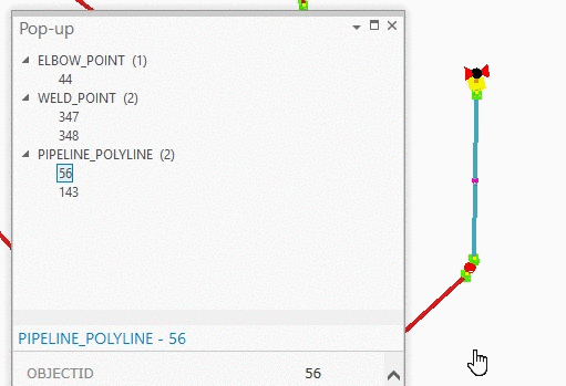
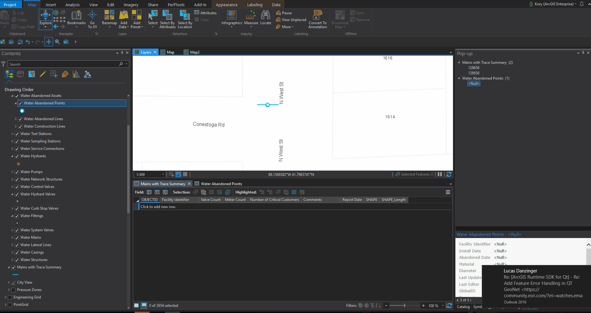
As you can see in the Pop-up, if a feature is covered by another feature, is cannot be selected. When I zoom in and can see a partial piece, then it will select it. Does this make sense? Again, I can provide more info if necessary.
Thanks for the details. Yes, the fact that you're working in a 3D scene does make a difference.
Select features interactively—ArcGIS Pro | ArcGIS Desktop
"In a scene view (3D), features blocked by terrain or other features will not be selected."
So the idea stands as reviewed. I'm not a product engineer, but it seems that there is a whole lot more that needs to be considered when selecting in 3D rather than 2D. Because you might have a scene tilted up - if I'm selecting something close to me (like a building) would I want it to select everything behind the building as well? If so, how far behind the building - 10 feet, 1 mile, 10 miles? Or just only select what I can see? I *think* that's what we're seeing (or not seeing) here.
We have the idea here and it is something that the development team can look into.
Thanks again for the clarifying details.
Just another thought on this - knowing that it is by design to select visible features (and not select non-visible features) in 3D, it might be possible to modify symbology and visibility ranges to help you work with your specific data in 3D.
Hello Kory, thank you for your continued assistance and attention to my
inquiry/idea. It is very much appreciated. I have unfortunately taken that
into account, and sadly if I make the symbology smaller, it won't be
visible. This is due to the range I was already at, with the video I posted
displaying 6ft to roughly 4ft from ground level. One of the issues that
arise is when I am trying to view the entire project and attempting to
select all features at once vs. manually using select all on each layer,
which of course some features get covered up by the fact the pipeline
segments are only 0.5ft in length in some areas, and other features get
covered by symbology. Also, most times when I am zoomed out, I'm trying to
select specific parts of the project vs. the whole project.
I agree with your previous comment about selecting features and not knowing
how far back to select features, but I always tilt my scene in a downward
fashion, so I don't select features on the same plane at various distances.
Does that make sense?
It would be helpful to be able to select features even if hidden by other
features symbology, maybe being able to have a selection option like the
one currently in the contents pane, but allowing even obstructed/covered up
features to be selected.
Im open to try anything, as long as the symbology is visible at close and
distant ranges.
Thank you again for your continued interest in attempting to resolve this
issue, it is greatly appreciated!
Best,
Jerad
You must be a registered user to add a comment. If you've already registered, sign in. Otherwise, register and sign in.