- Home
- :
- All Communities
- :
- Products
- :
- ArcGIS Pro
- :
- ArcGIS Pro Ideas
- :
- Display Geotagged Photos on Map
- Subscribe to RSS Feed
- Mark as New
- Mark as Read
- Bookmark
- Follow this Idea
- Printer Friendly Page
- Mark as New
- Bookmark
- Subscribe
- Mute
- Subscribe to RSS Feed
- Permalink
This enhancement would display geotagged photos on a map. Currently, it is possible to add an image as a map symbol, but this must be done symbol by symbol. The proposed enhancement would provide a database-driven solution, where the images (or thumbnails) would be displayed on the map, similar to Fotomaps (shown below) or Panoramio.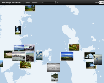
I'm completely agree with you all.
Since 2012, ArcPhoto is no longer disponible in ArcMAP.
However, ArcPhoto had very usefull tools that the new toolbox (Import geotagged photos) doesn't have. It's a pity!
That would be great that ESRI developpers integrate this:
1/ SHOW THE ARROW of direction of the photo (include in EXIF).
2/ CREATE thumbnails automatically that could cross from Dataview To LayoutView ( I can't imagine place manually hundreds of photos!!!!!!!!).
ArcPhoto is still available from Esri-- it is in ArcGIS Online at:
http://www.arcgis.com/home/item.html?id=578d358a575e4a8ea067a180e00b1325
Tom Emge (Esri superstar) last updated this January 6, 2017. Now I am looking to have the same tools in ArcGIS Pro-- will consider posting another idea for that.
This is implemented in ArcGIS Pro 2.7 through the following workflow:
- When you run the GeoTagged Photos to Points tool, add the photos as attachments.
- Join the resulting attachment table to the point feature class.
- Symbolize the points with a picture marker symbol and use attribute-driven symbology to point to the image data field in the joined table.
Also see 7:11 in the Ideas in ArcGIS Pro 2.7 video.
This is summarized in the what's new help as:
- The image used in a picture marker symbol layer can now be variable, set by an attribute.
@KoryKramer that's pretty cool. Here I was thinking it wasn't possible and it is.
Performance isn't great when panning, the images aren't converted to a thumbnail cache, so the load times are poor.
What about taking this symbology to a web map? A 'Map Tour' story map template wants to use pin symbols.
You must be a registered user to add a comment. If you've already registered, sign in. Otherwise, register and sign in.