- Home
- :
- All Communities
- :
- Products
- :
- ArcGIS Pro
- :
- ArcGIS Pro Ideas
- :
- Add ArcMap-esque a 'canceled' indicator when the d...
- Subscribe to RSS Feed
- Mark as New
- Mark as Read
- Bookmark
- Follow this Idea
- Printer Friendly Page
- Report Inappropriate Content
Add ArcMap-esque a 'canceled' indicator when the drawing of a map is canceled
- Mark as New
- Bookmark
- Subscribe
- Mute
- Subscribe to RSS Feed
- Permalink
- Report Inappropriate Content
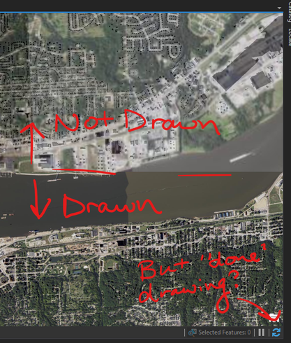
ArcGIS Pro is much better at not cancelling the drawing of your map than ArcMap. However, it still happens:
What's worse is that there's no indicator that this is happening as there is in ArcMap:
I'd like to see some sort of indicator, whether it's that same 'Canceled' label appearing somewhere or adding a new icon to that status bar that shows as a green checkmark/red cross type of thing. I could see the argument for a temporary green check appearing when it's done drawing, and a persistent red x if there are errors.
- Mark as Read
- Mark as New
- Bookmark
- Permalink
- Report Inappropriate Content
In the case you're presenting above, if you mouse over the view or interact with it at all does it continue drawing? Pro does "cancel" all the time when you're interacting (e.g. cancel requests that were made if they're no longer needed) to improve responsiveness.
The "refresh" behavior of the drawing indicator is designed to allow the user to hit refresh if they feel the drawing is incomplete. Are you able to replicate the behavior you're showing above? e.g. are you able to provide a repro case for the "cancelled, but incomplete" drawing behavior without you hitting Esc?
- Mark as Read
- Mark as New
- Bookmark
- Permalink
- Report Inappropriate Content
@KoryKramer It happens intermittently. I want to say that one cause is opening another window in front of Pro but I can't get it to do that right now. I also thought that maybe it was imagery layers, but those are behaving right now, too. So, I can't really identify a consistent rhyme or reason, but when it does happen - a little "hey! it's not quite finished!" would be great.
- Mark as Read
- Mark as New
- Bookmark
- Permalink
- Report Inappropriate Content
OK, thanks for the response. If you (or others who run across this thread) are able to share steps that lead to the behavior, that will be most helpful for teams to understand the cause of it. Thank you!
- Mark as Read
- Mark as New
- Bookmark
- Permalink
- Report Inappropriate Content
Hey @KoryKramer, I might have a lead for you - while I was loading up a map that contained this layer (https://gis.apfo.usda.gov/arcgis/services/NAIP/USDA_CONUS_PRIME/ImageServer) in a maximized Pro window, I switched to a maximized Firefox window in front of it. The map stopped loading the imagery layer. However, that doesn't seem to be the issue: even after some panning and zooming, it didn't want to appear, I had to nudge it quite a bit, and there are still instances where it'll say it's done loading but not show the imagery. No visibility ranges, either.
- Mark as Read
- Mark as New
- Bookmark
- Permalink
- Report Inappropriate Content
Oh, and yes, that's the same layer from my original post. I wonder what's going on with it.
- Mark as Read
- Mark as New
- Bookmark
- Permalink
- Report Inappropriate Content
@KoryKramer Here's another layer that gives up: https://services.arcgis.com/P3ePLMYs2RVChkJx/arcgis/rest/services/TIGER_Roads_2021_view/FeatureServe...
- Mark as Read
- Mark as New
- Bookmark
- Permalink
- Report Inappropriate Content
@KoryKramer Here is another example, not sure what the issue is here. I just zoomed out with the scroll wheel and you can see the line of where it stopped drawing the railroad tracks, which are saved in the project .gdb. Counties did not draw their labels, either. I'm sure there are times this has happened in Pro that I did not notice because the indicator was removed. Restoring the warning would be very useful in circumstances where it's not so obvious.
- Mark as Read
- Mark as New
- Bookmark
- Permalink
- Report Inappropriate Content
@wayfaringrob for the TIGER roads service, I got a toast notification > Display limit notification
Did you get that when a service stops drawing? I'm not sure about the latest example you've provided. What kind of data is in the map?
- Mark as Read
- Mark as New
- Bookmark
- Permalink
- Report Inappropriate Content
Ok, here's a parcel layer stored in a local .gdb. You can see it in the lower left portion of the map, but that's it.
It appears correctly on zoom, and sometimes if I zoom back out and move it, it'll get it to appear.
You must be a registered user to add a comment. If you've already registered, sign in. Otherwise, register and sign in.


