- Home
- :
- All Communities
- :
- Products
- :
- ArcGIS Pro
- :
- ArcGIS Pro Ideas
- :
- Add an indicator to data source tab in ArcGIS Pro ...
- Subscribe to RSS Feed
- Mark as New
- Mark as Read
- Bookmark
- Follow this Idea
- Printer Friendly Page
Add an indicator to data source tab in ArcGIS Pro to identify if dataset is compressed
- Mark as New
- Bookmark
- Subscribe
- Mute
- Subscribe to RSS Feed
- Permalink
To save space on large datasets held in a file geodatabase we often compress the dataset.
Currently in ArcGIS Pro one cannot gauge the performance of the compression as I indicate in this idea but also you cannot tell if the dataset is compressed, unless you right click on it in the catalog panel and go to Manage. In ArcCatalog it tells you its compressed, there is no equivalent in ArcGIS Pro.
This is problematic if you later decide to edit/process the dataset in ArcGIS Pro (e.g. update a field) as none of the tools work and you are left wondering why and having to investigate. Turns out the dataset is compressed and needs uncompressing.
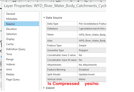
So this idea is to simply add some other way on indicating the dataset is compressed, an obvious solution that screams out to me is to put an indicator in the source tab of a layer properties, I sketch out an example below.
This is not a HUGE ask, it fits within the layout of the data source table and in my eyes would be a really useful flag to help me understand my dataset and why expected behaviour of tools suddenly stops.
This should be available in the layer and dataset properties in the coming release of ArcGIS Pro 2.9.
This is implemented in ArcGIS Pro 2.9. See Ideas in ArcGIS Pro 2.9 and go to 1:15 in the video for a little demo.
You must be a registered user to add a comment. If you've already registered, sign in. Otherwise, register and sign in.
