- Home
- :
- All Communities
- :
- Products
- :
- ArcGIS Parcel Fabric
- :
- ArcGIS Parcel Fabric Questions
- :
- Re: Chi Square test failed...
- Subscribe to RSS Feed
- Mark Topic as New
- Mark Topic as Read
- Float this Topic for Current User
- Bookmark
- Subscribe
- Mute
- Printer Friendly Page
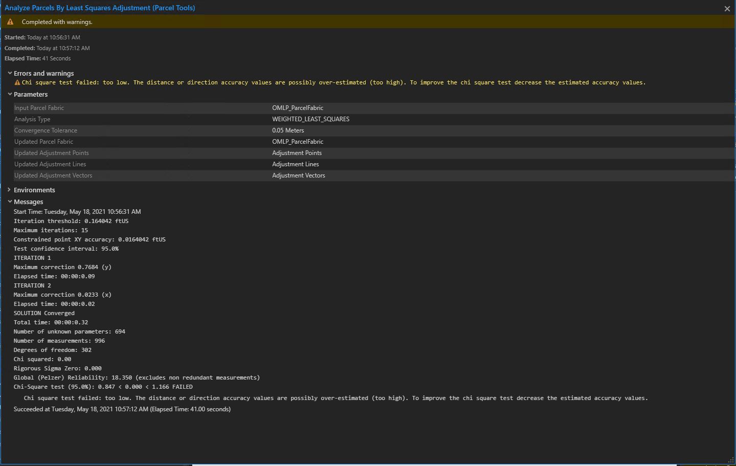
Chi Square test failed...
- Mark as New
- Bookmark
- Subscribe
- Mute
- Subscribe to RSS Feed
- Permalink
Hi -
Here is an explanation of the CHI test from the documentation:
"If the Chi-square test fails and is too low, the estimated a priori accuracies may be too low (meaning that the numeric accuracy values may be too high). To improve the test, increase the estimated accuracies (decrease the numeric values). For example, decrease a 30 seconds accuracy estimate for directions to 20 seconds and rerun the adjustment.
If the Chi-square test fails and is too high, the estimated a priori accuracies may be too high (meaning that the numeric accuracy values may be too low). To improve the test, first use the adjustment feature classes to identify and correct any measurements that are flagged as outliers. Then rerun the adjustment. If there are no measurements flagged as outliers, decrease the estimated accuracies (increase the numeric values). For example, increase a 0.59-foot estimate for distances to 0.8 feet."
So for you, you need to go ahead and increase your a-priori accuracies (decrease the numeric values).
"A priori accuracies are specified in the Direction Accuracy and Distance Accuracy fields of the parcel line or connection line feature class. If the fields are missing accuracies, the defaults of 30 seconds for directions and 0.15 meters (0.49 feet) for distances are used."
See this help topic for more information
https://pro.arcgis.com/en/pro-app/latest/help/data/parcel-editing/runleastsquaresadjustment.htm
Let us know if this helps answer your question or if you have any more questions.
Regards
Christine
- Mark as New
- Bookmark
- Subscribe
- Mute
- Subscribe to RSS Feed
- Permalink
Christine,
Thank you for the reply. I have been incrementally decreasing the numeric value for both fields in all pertinent parcel line features but I still keep getting the warning message. Should I just keep decreasing the values until the warning message disappears?
I feel like I am just picking numeric value out of thin air, is there a “systematic” way I should be going about this?
Chad
- Mark as New
- Bookmark
- Subscribe
- Mute
- Subscribe to RSS Feed
- Permalink
Another question I had is, am I supposed to select the constrained control points when performing a adjustment?
Thanks
- Mark as New
- Bookmark
- Subscribe
- Mute
- Subscribe to RSS Feed
- Permalink
Hi Chad
Are the dimensions on your parcel lines generated from the geometry (inversed)?
If dimensions are generated from the line geometry there is no error. So any a priori accuracies you put in will always return a Too Low Chi test - because there is zero error in the measurements. In this case the CHI test is not really meaningful.
Chi test will start to become meaningful once "real" dimensions are added from the record. How does your data look - are the dimensions from the record?
For the constrained adjustment:
A selection of both parcels and lines can be used as input to the least-squares analysis. When parcels are selected, dimensions on the parcel lines and coordinates of the endpoints of the parcel lines will be used as input to the adjustment. If lines or connection lines are individually selected, the dimensions on the lines and the coordinates of its endpoints will be used as input to the adjustment.
It is not necessary to select the control points.
Christine
- Mark as New
- Bookmark
- Subscribe
- Mute
- Subscribe to RSS Feed
- Permalink
@Lebowski Would it make sense to meet with you where you can:
- Explain your use-case
- Show us your data
- Better understand your challenge
- Examine the results
Thanks,
Amir
- Mark as New
- Bookmark
- Subscribe
- Mute
- Subscribe to RSS Feed
- Permalink
Amir (& Christine)
Thank you for your replies! A meeting would be great!
Brief background, our PF is in a statewide database, it houses the lands the Illinois Department of Natural Resources (IDNR) owns, manages, and leases. Each site (State Park XYZ) is made up of parcels conveyed via Deeds, Easement Deed's, Lease Agreements, etc. The PLSS was also digitized for any parcel IDNR owns, manages, and leases. PLSS goes from the section to quarter-quarter (1/16th sections) level. Previous SDE-GDB was based on The ArcGIS Parcel Data Model, von Meyer. Properties and PLSS were digitized from legal descriptions, original survey notes and plats, aerial photography, etc. Recently migrated our previous GDB to the Pro PF and have Enterprise stood up and can edit via branch versioning.
I work closely with the IDNR Surveyor and would like to begin the process of importing his survey points as control points and have them replace corresponding PF points too. This will likely be done incrementally, on a site-by-site basis. His control points are either PLSS related (section corners, quarter corners, etc.) or parcel related (parcel control corners). Furthermore, we want existing features related to the point(s) to move too.
I have been testing with Transform (modify pane), LSA, and most recently the Import PF Points GP tool. I can get all three to execute but I am not 100% sure which method I should be using? Thus far it seems that the Import PF Points GP tool works best but it is a manual process. LSA I am unclear on some of the accuracy values I should be entering and what kind of adjustment should I be seeing?
Thank you,