- Home
- :
- All Communities
- :
- Products
- :
- ArcGIS Parcel Fabric
- :
- ArcGIS Parcel Fabric Ideas
- :
- Include Retired Parcels in "Build Active Record"
- Subscribe to RSS Feed
- Mark as New
- Mark as Read
- Bookmark
- Follow this Idea
- Printer Friendly Page
Include Retired Parcels in "Build Active Record"
- Mark as New
- Bookmark
- Subscribe
- Mute
- Subscribe to RSS Feed
- Permalink
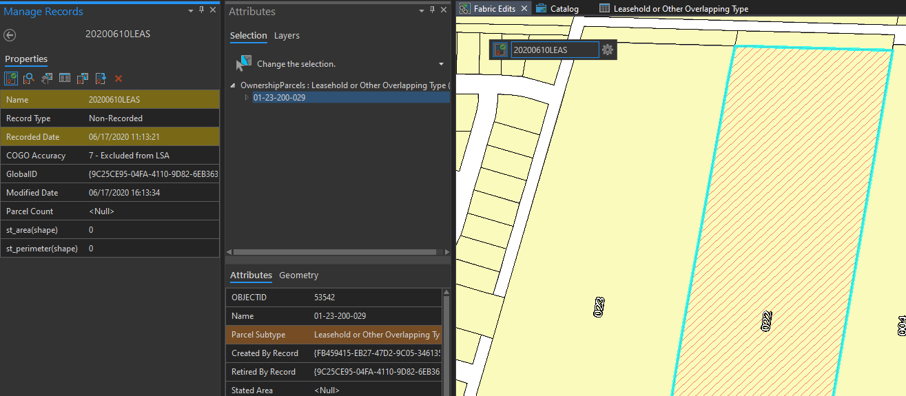
Our county has a number of leasehold parcels that lie atop existing parcels. Occasionally, the leasehold will be terminated. In this situation, the active record in the Parcel Fabric only retires a feature, with no features created.
Currently, "Build Active Record" only looks at parcels with the record's globalid in their "createdbyrecord" attribute, so in the situation described above, the record will always have a null geometry.
It would be great if the Fabric looked at both created and retired attributes when it built the record geometry.
Instead of using 'Build in Active Record' command, you might want to use the following workflow:
1. Create the retiring record (it will be Active now)
2. From the tool gallery choose the 'Set Historic' command

This will retire the selected lease that is terminated.
Would this work?
Thanks for the clarification Josh,
The lease was originally created by record A which I assume has the correct record footprint and parcel count.
Now, record B is retiring the lease.
So isn't it correct that record B created 0 parcels (ParcelCount=0) and therefore should have no geometry?
How are you using the records geometry?
Do you need to know how many parcels each record retired? if yes - for what purpose? QA against a business system?
When we implement user interface for parcel lineage we can expose how many parcels (and which) each record created and retired.
thx
.
We use the records geometry in a public dashboard to show "here's where the changes happened", essentially. End users in the Assessments office and members of the public click on the record name and it zooms to the feature and shows them parcels created/retired by that record. For the vast majority of our records, this works perfectly, but these few lease retirements, lacking geometry, do not.
It's very minor, as problems go, and our dashboard provides users other methods to find the parcels created or retired in a given record. I know our county is not necessarily representative of all Parcel Fabric users, but we never really have records in which the retired features would have a different footprint than those created, except in these cases when there are no created features, so it seemed to me that by building the record geometry to encompass both created and retired features would be simple enough.
Thanks for sharing.
Every use case is valid so:
1. Would be willing to describe and promote your idea in this meetup Parcel Fabric Ideas and Licensing clarifications | Meetup?
2. Interim solution - the records' geometry can also be created manually(until we have a solution).
The question at hand is:
1. Do we want the records' geometry to also include the retired parcels? no harm in that since they usually overlap anyhow.
2. It seems there is no need for the ParcelCount to include retired parcels (please correct if wrong)
Yes, absolutely! I was planning to attend the meetup if my schedule permits. I’ll go with the manual creation for the time being. Related to that: would running “Build Fabric” or “Build Extent” delete the manually created geometry?
1. Yes, I’d appreciate if the record geometry included the retired parcels.
2. You’re correct, the Parcel Count need not include them.
Implemented in ArcGIS pro 2.9 release.
You must be a registered user to add a comment. If you've already registered, sign in. Otherwise, register and sign in.
