- Home
- :
- All Communities
- :
- Products
- :
- ArcGIS Online
- :
- ArcGIS Online Questions
- :
- Re: WFS OGC filtering
- Subscribe to RSS Feed
- Mark Topic as New
- Mark Topic as Read
- Float this Topic for Current User
- Bookmark
- Subscribe
- Mute
- Printer Friendly Page
WFS OGC filtering
- Mark as New
- Bookmark
- Subscribe
- Mute
- Subscribe to RSS Feed
- Permalink
The following HTTP GET request filters the WFS service. Only one features is being returned.
Option A:
Option B:
When applying this in ArcGIS Online using the WFS OGC options it doesn’t work.
ArcGIS Online makes a HTTP POST request, and the WFS server ignores the filter.
How to overcome these problems?
Are there working examples available where thes WFS OCG paramaters work, so we can learn from them?
- Mark as New
- Bookmark
- Subscribe
- Mute
- Subscribe to RSS Feed
- Permalink
 Hi Gemeente Roosendaal,
The goal is to show the municipality of Roosendaal on the map.
As an alternative to the WFS Service from PDOK/Nationaal Georegister you might also consider to use Open Data provided by Esri Nederland.
 Esri Nederland offers more and more Open Data for the Netherlands as web services, which is very convenient for the Dutch ArcGIS community.
In this case we need the Feature Layer Gemeenten (Bestuurlijke Grenzen 2019) which can be added via ArcGIS Online.
 After adding this layer you van apply a filter and modify the style.
Would this be a nice workaround to solve your issue?
BR,
Egge-Jan
- Mark as New
- Bookmark
- Subscribe
- Mute
- Subscribe to RSS Feed
- Permalink
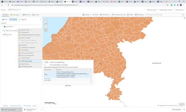
Thank you for the reply Egge-Jan. I have added the above WFS service as an example in order to illustrate the problem were are having. For our use case we using different WFS services which can not be found in open data alternatives nor being published using ArcGIS server or hosted feature services. Our case requires a WFS OGC integration in ArcGIS online.
- Mark as New
- Bookmark
- Subscribe
- Mute
- Subscribe to RSS Feed
- Permalink
I have continuously been struggling with the same problem, where I cannot filter on a parameter value in a layer from an OGC WFS-service. In Arcgis Pro the WFS is working and I can set a definition query but I can not do the same in web maps from AGOL/Portal. As our users try to consume national, public data services this is a much needed functionality.
An example of a service is:
https://fkg.mapcentia.com/ows/fkg/fkg?SERVICE%3DWFS
which works fine in Arcgis Pro and I can add the layer "Friluftsliv faciliteter, linjer (5802) to a map and set a definition query based on a parameter value. Similarly, I can add the layer to a web map but I can not add any query in the URL nor in the WFS OGC Options/custom parameters. Is there no opportunity to add this functionality to web maps?