- Home
- :
- All Communities
- :
- Products
- :
- ArcGIS Online
- :
- ArcGIS Online Questions
- :
- Re: urgent! - Elevation Profile Web app stopped wo...
- Subscribe to RSS Feed
- Mark Topic as New
- Mark Topic as Read
- Float this Topic for Current User
- Bookmark
- Subscribe
- Mute
- Printer Friendly Page
urgent! - Elevation Profile Web app stopped working (error 000824)
- Mark as New
- Bookmark
- Subscribe
- Mute
- Subscribe to RSS Feed
- Permalink
Hi all!
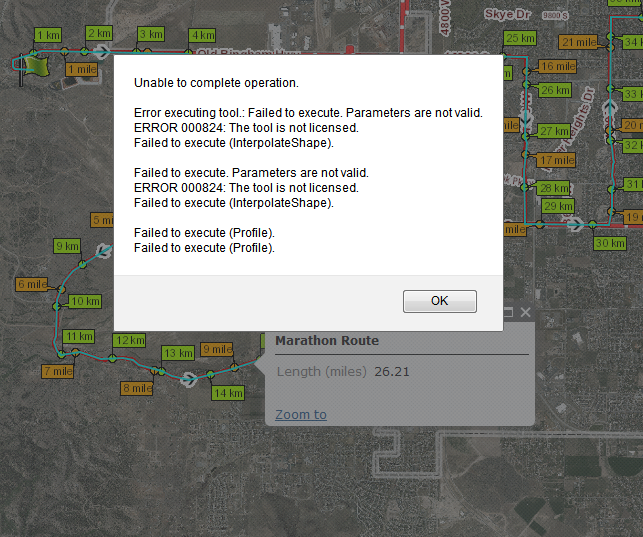
I have a couple webmaps that are using the Elevation Profile web app template. Since this morning, however, the application is throwing an error (Error 000824), and the profile is no longer showing (see attached image)
Any idea what's going on here? We haven't changed anything on the map in the last few weeks, and it was working fine up until yesterday.
Thanks!
Marc
Solved! Go to Solution.
Accepted Solutions
- Mark as New
- Bookmark
- Subscribe
- Mute
- Subscribe to RSS Feed
- Permalink
Marc,
We are investigating this issue and hope to have a resolution soon.
Thanks
Kelly
- Mark as New
- Bookmark
- Subscribe
- Mute
- Subscribe to RSS Feed
- Permalink
I'm sorry for bumping this, but we already had a few complaints about this issue from our citizens, since the marathon race is coming up this weekend.
I also noticed that this issue occurs with every map that I tried to make into an (elevation profile) app. Even downloading the app and running it from our server throws the same error message.
If this is an ESRI issue, I sure hope they'll fix it. Fast.
Marc
- Mark as New
- Bookmark
- Subscribe
- Mute
- Subscribe to RSS Feed
- Permalink
Marc,
We are investigating this issue and hope to have a resolution soon.
Thanks
Kelly
- Mark as New
- Bookmark
- Subscribe
- Mute
- Subscribe to RSS Feed
- Permalink
Kelly, thanks for looking into this!
- Mark as New
- Bookmark
- Subscribe
- Mute
- Subscribe to RSS Feed
- Permalink
Kelly,
not sure what kind of magic you performed, but it works again!
Thanks a ton for the fast response and fix!!!!
Marc
- Mark as New
- Bookmark
- Subscribe
- Mute
- Subscribe to RSS Feed
- Permalink
Kelly,
I know this is an old post and it is related to an AGOL profile service, but I am in desperate need of help with implementing the developer sample found here:
http://www.arcgis.com/home/item.html?id=0d47b17d3b884b9d977a6f76fc6bfcaa
I can run the pyhon script successfully from inside ArcMap and then create the geoprocessing service from the sucessful results, however when I try to run the geoprocessing service, I get the [ERROR 000824: The tool is not licensed] error. I have even hard coded the arcpy syntax for checking out the 3D and Spatial extensions in the python script. Again, it works in ArcMap (even when I don't enable the extensions from the Customize>Extensions menu.
Any insight or help on what you had to do to fix this in 2014 (I know it was a long time ago) would be very much appreciated. I'm hoping there is somewhere in this python script that I have to force it to check out the extension licenses... I've verified they are available from the LIcense Manger and I'm using Server Advanced (though there has been some confusion on the comments section on whether this is required or only the Desktop extensions).
Any help would be very much appreciated!!!! Cheers!
-Vince
- Mark as New
- Bookmark
- Subscribe
- Mute
- Subscribe to RSS Feed
- Permalink
Vince,
I'm sorry I am not familiar with getting the tool up and running only with using the resulting service from a web app.