- Home
- :
- All Communities
- :
- Products
- :
- ArcGIS Online
- :
- ArcGIS Online Questions
- :
- Re: Slope analysis failed
- Subscribe to RSS Feed
- Mark Topic as New
- Mark Topic as Read
- Float this Topic for Current User
- Bookmark
- Subscribe
- Mute
- Printer Friendly Page
- Mark as New
- Bookmark
- Subscribe
- Mute
- Subscribe to RSS Feed
- Permalink
Hello,
I'm new to raster analysis in ArcGIS online and trying to apply my knowledge from ArcMap to this platform. With the availability of the ArcGIS Image extension, I thought I'd develop some raster exercises for my students.
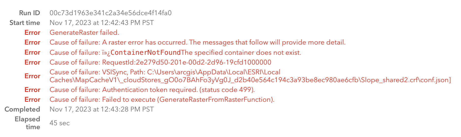
I'm working with a 10m DEM of Oregon (Elevation Framework - 10m DEM (Oregon Lamber Int'l Feet)) that's readily available online. I thought I'd start out with a simple slope and aspect calculation. When I set up the slope raster analysis tool using this DEM, I'm able to see a preview of the analysis without any problem. However when I run the analysis, the process unfolds for a while, but always kicks out a "Slope failed" message. A layer is created, but it can't be opened since it's a failed product.
I've attached a snapshot of the error log below. What simple step am I missing? I see that I may need to adjust the Z factor, since the map is in feet and the analysis may be in meters, but that's not the cause of the failure. I don't see any caveats in the tool description about initial steps or prep that I'm not doing. I've tried running the slope tool using a DEM from another source, but still have the analysis fail. Is there something I'm overlooking with my source layer? Or could it be something I haven't set up properly in AGOL?
Any ideas?
- Rich
Solved! Go to Solution.
Accepted Solutions
- Mark as New
- Bookmark
- Subscribe
- Mute
- Subscribe to RSS Feed
- Permalink
Hi Rich,
Perform analysis is guarded with a few imagery layer settings, including the allowed size limit for a single request, a detailed reading could be found here: Understand imagery layer settings for analysis—ArcGIS Online | Documentation.
For the failure in your original post, currently I am trying to see the failure on my end, but not yet able to reproduce on the same hive you were on. We are looking deeper into finding the possible cause and fixing it. In the meantime if possible, could you try once more with a processing extent within the size limitation? Thanks. Ling

- Mark as New
- Bookmark
- Subscribe
- Mute
- Subscribe to RSS Feed
- Permalink
I wonder if its simply too big? Oregon is a big state and that has to be a sizeable raster at 10m resolution. Depending on what you intend to do with the output you might consider resampling the DEM to a larger cell size.
- Mark as New
- Bookmark
- Subscribe
- Mute
- Subscribe to RSS Feed
- Permalink
Good point. I can try resampling the cell size to reduce the resolution. However I’ve already reduced the extent of the analysis to a very small region using display extent under environments. It fails even when running a slope analysis that uses one credit. Shouldn’t this be an indicator of a pretty small analysis?
it’s frustrating to see the slope result I’m looking for in the preview, yet not be able to create a result layer due to a failed analysis. I’d love to know what I’m doing wrong.
- Mark as New
- Bookmark
- Subscribe
- Mute
- Subscribe to RSS Feed
- Permalink
Follow-up question for those in the know. I really can't do anything in terms of raster analysis with the DEM models that I have available to me. It seems like the common thread in the error messages is the sentence "The allowed maximum number of rows and columns is 4100 and 15000 respectively. Please adjust the output extent and/or cellsize to fit within the limits." (with some variation in the numbers, depending on the tool attempted). This occurs regardless of limitations I impose on the processing extent.
I can't resize the cells or clip the DEM due to the row/column limitations noted above. Do I need to turn to ArcGIS Pro in order to clip the DEM to a more manageable size and bring the result into AGOL? If so, that's a frustrating limitation. Why provide the tools if none will work with the DEMs available online.
I'll give resizing in Pro a try tomorrow. Other suggestions are more than welcome.
- Rich
- Mark as New
- Bookmark
- Subscribe
- Mute
- Subscribe to RSS Feed
- Permalink
Hi Rich,
Perform analysis is guarded with a few imagery layer settings, including the allowed size limit for a single request, a detailed reading could be found here: Understand imagery layer settings for analysis—ArcGIS Online | Documentation.
For the failure in your original post, currently I am trying to see the failure on my end, but not yet able to reproduce on the same hive you were on. We are looking deeper into finding the possible cause and fixing it. In the meantime if possible, could you try once more with a processing extent within the size limitation? Thanks. Ling
- Mark as New
- Bookmark
- Subscribe
- Mute
- Subscribe to RSS Feed
- Permalink
It does seem to be a processing extent limitation. I was able to open the DEM in ArcGIS Pro and export a smaller extent as a GeoTiff, which I then uploaded to ArcGIS Online. The smaller version of the DEM worked without any issues.
I am surprised that there appears to be no way of resizing a DEM within ArcGIS Online. If the source layer exceeds the row and column limitations, then it can't be processed at all using raster analysis. It would be very helpful to have tools available to downsize the raster and then proceed with analysis.