- Home
- :
- All Communities
- :
- Products
- :
- ArcGIS Online
- :
- ArcGIS Online Questions
- :
- Removing/ erasing a defined area from a multiband ...
- Subscribe to RSS Feed
- Mark Topic as New
- Mark Topic as Read
- Float this Topic for Current User
- Bookmark
- Subscribe
- Mute
- Printer Friendly Page
Removing/ erasing a defined area from a multiband raster image
- Mark as New
- Bookmark
- Subscribe
- Mute
- Subscribe to RSS Feed
- Permalink
I am trying to refine the results of a supervised landscape classification analysis by removing large bodies of water whose reflection overlaps with the signature of an impervious class. I am working with a multiband raster (RBG) and have tried a few workflows but have yet to achieve the desired results.
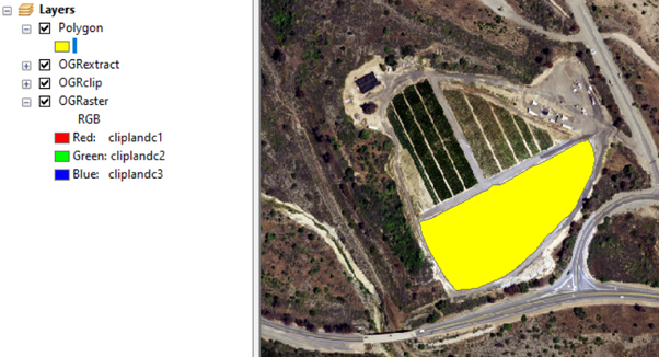
Workflow 1: Create a polygon around the desired areas --> clip raster --> extract by mask
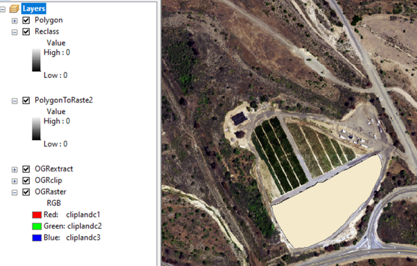
Workflow 2: Create a polygon around the desired areas --> Polygon to raster --> Reclassify --> Set Null
Workflow 1 yields the opposite of what I want, while Workflow 2 creates a raster that lacks the RBG bands and is blank. I suspect it is an error in the reclassification step, but I am not sure.
Any suggestions/ ideas would be greatly appreciated.


- Mark as New
- Bookmark
- Subscribe
- Mute
- Subscribe to RSS Feed
- Permalink
Is this function available on the desktop version, or is this a ArcGIS Pro exclusive?
- Mark as New
- Bookmark
- Subscribe
- Mute
- Subscribe to RSS Feed
- Permalink
Sorry, didn't notice AGOL.
This is for ArcGIS Pro, I don't use online for editing/modifying data
... sort of retired...
- Mark as New
- Bookmark
- Subscribe
- Mute
- Subscribe to RSS Feed
- Permalink
Got it, I am a graduate student at CSULB and I have access to ArcMap. I will see if I can get access to ArcGIS Pro so that I can run the simple function. In the meantime, do you have any suggestions on how to do this on ArcMap?
I appreciate your help and your time
Best,
Max
- Mark as New
- Bookmark
- Subscribe
- Mute
- Subscribe to RSS Feed
- Permalink
Would it be possible to create a polygon of your total investigation area, erase the digitized polygons of the lakes and then use the raster clip tool?
- Mark as New
- Bookmark
- Subscribe
- Mute
- Subscribe to RSS Feed
- Permalink
I thought about it, and I am will try on a smaller raster to see if it works. But my analysis deals with a large part of Orange County, so drawing a polygon around the entire raster seems cumbersome. Unless there is an option to instantly create a polygon that matches the area of the raster.
- Mark as New
- Bookmark
- Subscribe
- Mute
- Subscribe to RSS Feed
- Permalink
If you just want to make a rectangle, use the "square" option, specify/select the extent you want, do a bit of multiplication to specify the area as being the same as the extent (length * width .... hoping you have projected data) and you should have a big square
... sort of retired...
- Mark as New
- Bookmark
- Subscribe
- Mute
- Subscribe to RSS Feed
- Permalink
I found an alternative that yields the desired results, the workflow is as follows: 1st. Using the Draw Menu create two polygons (one of the total extent of the raster), the second for the area that needs to be excluded. 2nd. Use "Graphics Operations" from the drawing menu and select "Remove Overlap". 3rd. Convert them to features (.shp) using the "convert graphics to features" and lastly 4th. "extract by mask"