- Home
- :
- All Communities
- :
- Products
- :
- ArcGIS Online
- :
- ArcGIS Online Questions
- :
- Python API Published Data is visible on map and ye...
- Subscribe to RSS Feed
- Mark Topic as New
- Mark Topic as Read
- Float this Topic for Current User
- Bookmark
- Subscribe
- Mute
- Printer Friendly Page
Python API Published Data is visible on map and yet can't be accessed outside the map
- Mark as New
- Bookmark
- Subscribe
- Mute
- Subscribe to RSS Feed
- Permalink
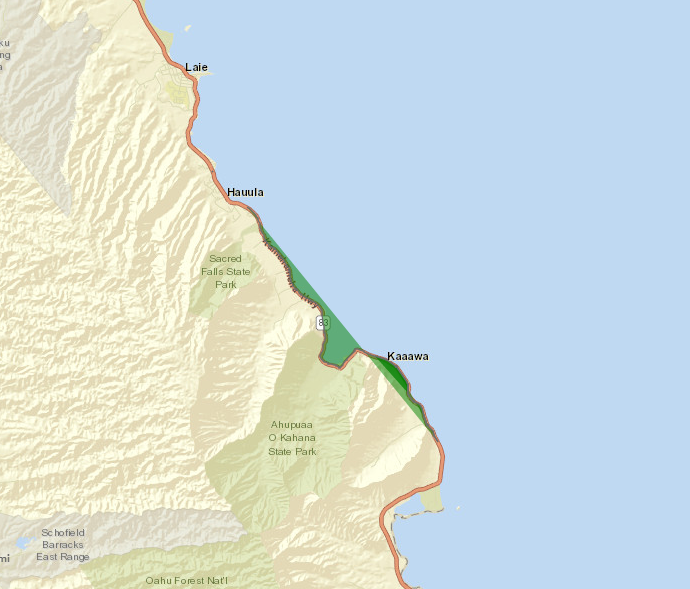
Can't seem to figure out why a path geometry showed up as polygon and then while I can see it in the mapviewer I can't seem to access the data through the item details. It shows that I have 190 features but then I can't view the data outside the map browsing interface.
The feature layer was created using pyhton api. The geometry is good and the dataset is posted formatted as a geojson and zipped file.
Code used to create (shown below) is based on a GeoAccessor from a dataframe with a SHAPE column for the geometry and the geometry is given as multilinestring. But the map shows it as a polygon and it is not.
hemafeatfcol = hemageoac.to_feature_collection(name='Emergency Repair and Maintenance projects', drawing_info=None, extent=None, global_id_field=None)
hemainfcdict = dict(hemafeatfcol.properties)
hemainjson = json.dumps({"featureCollection": {"layers": [hemainfcdict]}})
#print (" JSON feature collection : {} ".format(hemainjson))
hemainitem_properties = {'title': 'HDOT Emergency Repair and Maintenance projects ' ,
'description':'HDOT Emergency Repair and Maintenance projects ' + \
'Using HWY-C Excel data ',
'tags': 'projects, pss, HDOT, repair, status, maintenance ',
'text':hemainjson,
'type':'Feature Collection'}
hemainitem = qgis.content.add(hemainitem_properties)
HDOT Emergency Repair and Maintenance projects (arcgis.com) .
GeoJSON link https://histategis.maps.arcgis.com/home/item.html?id=0345cf4f8c484cf693087e170cf0c9cb
Polylines Map data that I can see but can't download or access any other way - https://histategis.maps.arcgis.com/home/webmap/viewer.html?webmap=6bb9e57538184d23b0699cd075c4b07a