- Home
- :
- All Communities
- :
- Products
- :
- ArcGIS Online
- :
- ArcGIS Online Questions
- :
- Re: Map with web layers shared with different grou...
- Subscribe to RSS Feed
- Mark Topic as New
- Mark Topic as Read
- Float this Topic for Current User
- Bookmark
- Subscribe
- Mute
- Printer Friendly Page
Map with web layers shared with different groups
- Mark as New
- Bookmark
- Subscribe
- Mute
- Subscribe to RSS Feed
- Permalink
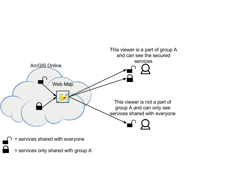
I want to create a map that is accessible to my entire organization but the map would show different layers to the viewer depending on what groups they are a part of in AGOL. Right now I have a map that is shared with the entire organization and contains some feature services that are only shared with a selected group within our organization. The problem is that when I share this map out, people who are not a part of the selected group see an empty basemap with nothing. I want them to be able to see the public layers but not the private ones.
How could I go about doing this?
Here is a picture of what I would like to see:
Any ideas on this would be greatly appreciated.
Thanks!
Solved! Go to Solution.
Accepted Solutions
- Mark as New
- Bookmark
- Subscribe
- Mute
- Subscribe to RSS Feed
- Permalink
I think the only way to achieve this is to create more than one web map, and share them with different groups. The webmaps can still reference some of the same services. I'm curious as to why you'd like it to be one single webmap.
- Mark as New
- Bookmark
- Subscribe
- Mute
- Subscribe to RSS Feed
- Permalink
That is a good point Tobias, We could create more than one web map and share them with different groups. In my initial idea I thought for simplicity's sake we could maybe get away with one map. It would be slick though to have one map for instance that is accessible to both internally and to the public that would display different layers based on what groups the user is a part of.
It is easy to create multiple maps though so I can see how that would also be an option.
Thanks!
- Mark as New
- Bookmark
- Subscribe
- Mute
- Subscribe to RSS Feed
- Permalink
I have since found that this functionality is available using Geocortex Essentials from Latitude Geographics. I am still figuring out the details of how to implement this out to our various use cases.