Turn on suggestions
Auto-suggest helps you quickly narrow down your search results by suggesting possible matches as you type.
Cancel
- Home
- :
- All Communities
- :
- Products
- :
- ArcGIS Online
- :
- ArcGIS Online Questions
- :
- How to Enable Attachments on Hosted Feature Servic...
Options
- Subscribe to RSS Feed
- Mark Topic as New
- Mark Topic as Read
- Float this Topic for Current User
- Bookmark
- Subscribe
- Mute
- Printer Friendly Page
How to Enable Attachments on Hosted Feature Service
Subscribe
06-02-2013
08:50 AM
- Mark as New
- Bookmark
- Subscribe
- Mute
- Subscribe to RSS Feed
- Permalink
The link below in the ArcGIS.com online help under the Tip section, discusses being able to choose "Enable attachments" under a feature service layer in ArcGIS.com. I would like to do this from some hosted feature layers I have published from ArcMap using my ArcGIS online subscription account. However, I can't seem to get a hosted feature service layer to show this option. Is there something I need to do in ArcMap to enable attachments before publishing to ArcGIS online? Or something I can do once it's published? I've looked everywhere and can't find any help for this in the online help either.
http://resources.arcgis.com/en/help/arcgisonline/index.html#//010q000000n0000000
http://resources.arcgis.com/en/help/arcgisonline/index.html#//010q000000n0000000
Solved! Go to Solution.
1 Solution
Accepted Solutions
06-03-2013
09:37 AM
- Mark as New
- Bookmark
- Subscribe
- Mute
- Subscribe to RSS Feed
- Permalink
Hello,
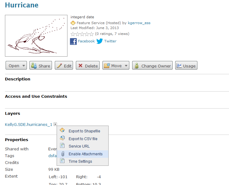
Enabling attachments to a hosted feature service is an operation that you can perform after the service has been published to ArcGIS Online. You will need to click on the sideways arrow beside the feature layer and a drop down should appear with an option to enable attachments. I have attached a screenshot of this image.
If this drop down is not appearing, please share the feature service URL.
Thanks,
Kelly
[ATTACH=CONFIG]24938[/ATTACH]
3 Replies
06-03-2013
09:37 AM
- Mark as New
- Bookmark
- Subscribe
- Mute
- Subscribe to RSS Feed
- Permalink
Hello,
Enabling attachments to a hosted feature service is an operation that you can perform after the service has been published to ArcGIS Online. You will need to click on the sideways arrow beside the feature layer and a drop down should appear with an option to enable attachments. I have attached a screenshot of this image.
If this drop down is not appearing, please share the feature service URL.
Thanks,
Kelly
[ATTACH=CONFIG]24938[/ATTACH]
02-02-2015
04:24 AM
- Mark as New
- Bookmark
- Subscribe
- Mute
- Subscribe to RSS Feed
- Permalink
Thanks, this is very helpful. I've been looking hours for that tiny arrow and really helped with the screenshot. I think ArcGISOnline help should add the screenshot as well to help us getting oriented.
04-22-2024
12:18 PM
- Mark as New
- Bookmark
- Subscribe
- Mute
- Subscribe to RSS Feed
- Permalink
Crack tip, thanks 😃