- Home
- :
- All Communities
- :
- Products
- :
- ArcGIS Online
- :
- ArcGIS Online Questions
- :
- Re: How can I set the OPENING extent of a single m...
- Subscribe to RSS Feed
- Mark Topic as New
- Mark Topic as Read
- Float this Topic for Current User
- Bookmark
- Subscribe
- Mute
- Printer Friendly Page
How can I set the OPENING extent of a single map or service in ArcGIS Online based on values (name) of school location using a hyperlink?
- Mark as New
- Bookmark
- Subscribe
- Mute
- Subscribe to RSS Feed
- Permalink
To provide a Webmap of Current School Locations or Zone Boundaries in a dynamic format, while also providing links from School websites.

We are trying to replace a bunch of static maps that would pop in new browser windows with ArcGIS Online content/service. From a particular school webpage they would select or click on a hyper link that would take the user to a WebApp that centered around their school, without user inputs once they had clicked on link.
Solved! Go to Solution.
Accepted Solutions
- Mark as New
- Bookmark
- Subscribe
- Mute
- Subscribe to RSS Feed
- Permalink
Nathan Wood You can do this by making a small update to your web map. In your current example you add the school to the map using the map service but instead try removing that layer and adding it as a feature layer where you point directly to the sub layer id. For example add a layer to your map from the web and specify this url:
http://gis.mnps.org/arcgis/rest/services/MNPS_Zones/MNPS_Current_School_List/MapServer/0
Once you've done that you can use the Basic Viewer configuration option to configure the url param to search the specified layer and field. Here's an example where we select the MNPS Current School List and pick the CLUS_NAME as the search field. We also define the name of the url param - this can be anything you want it to be - here we used cluster.
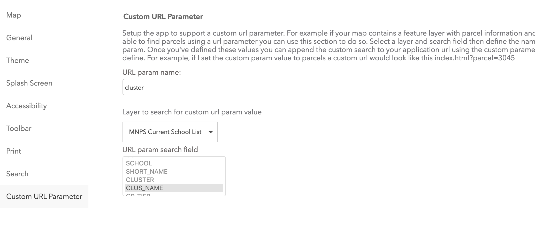
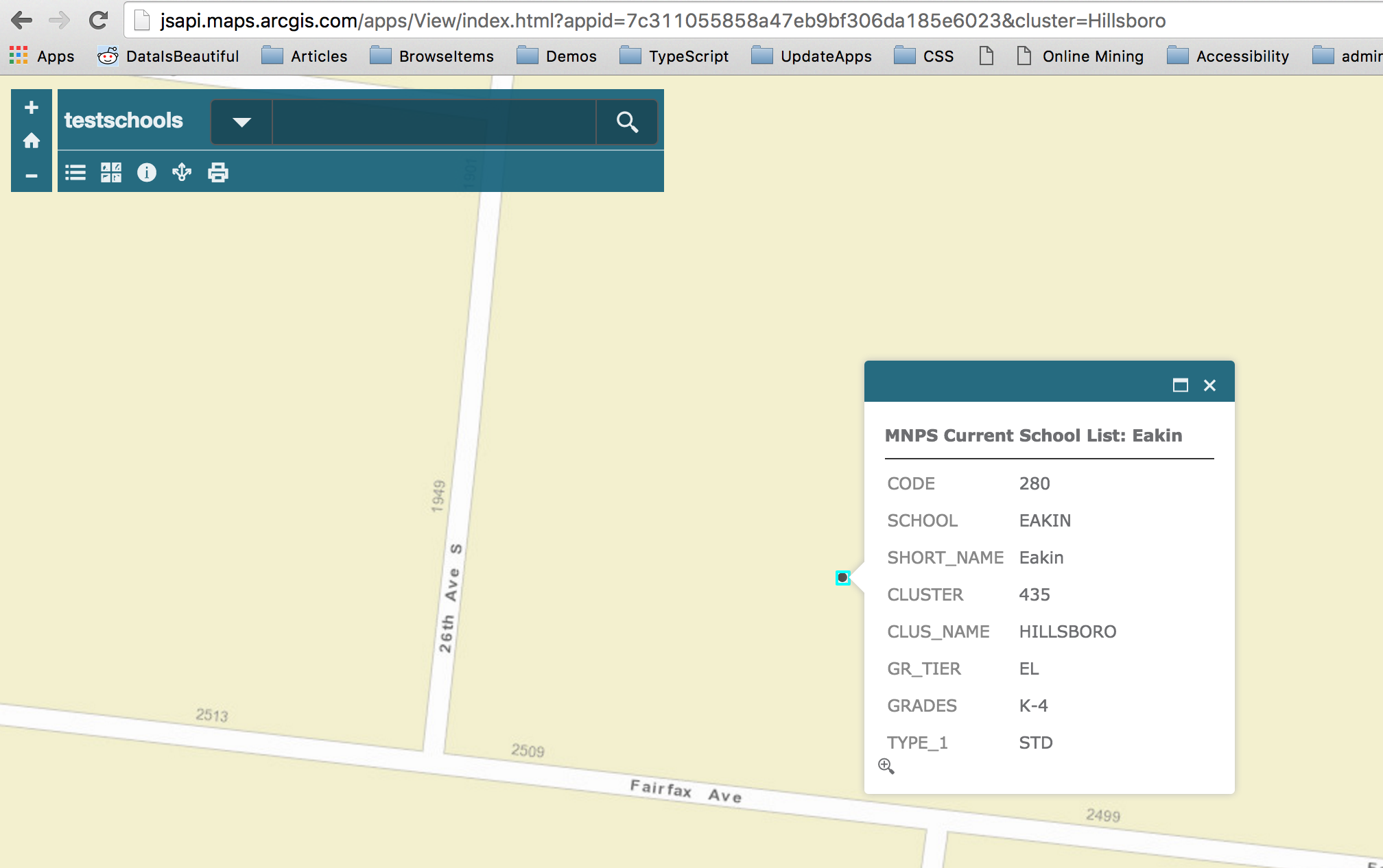
Then if you append the cluster url param with the value you want to search the app will zoom in to that location when it starts. In this example we search for cluster=Hillsboro
In the future we'd like to be able to support choosing url search layers from a map service instead of requiring that you add a feature layer.
- Mark as New
- Bookmark
- Subscribe
- Mute
- Subscribe to RSS Feed
- Permalink
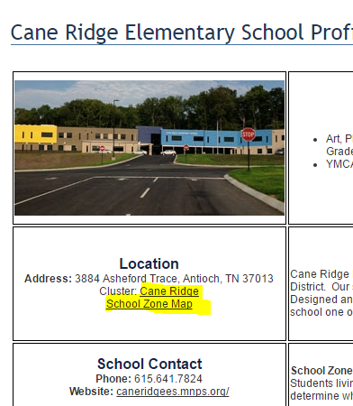
here is a look at school page with highlighted links for old pdf maps.
- Mark as New
- Bookmark
- Subscribe
- Mute
- Subscribe to RSS Feed
- Permalink
Nathan Wood You can do this by making a small update to your web map. In your current example you add the school to the map using the map service but instead try removing that layer and adding it as a feature layer where you point directly to the sub layer id. For example add a layer to your map from the web and specify this url:
http://gis.mnps.org/arcgis/rest/services/MNPS_Zones/MNPS_Current_School_List/MapServer/0
Once you've done that you can use the Basic Viewer configuration option to configure the url param to search the specified layer and field. Here's an example where we select the MNPS Current School List and pick the CLUS_NAME as the search field. We also define the name of the url param - this can be anything you want it to be - here we used cluster.
Then if you append the cluster url param with the value you want to search the app will zoom in to that location when it starts. In this example we search for cluster=Hillsboro
In the future we'd like to be able to support choosing url search layers from a map service instead of requiring that you add a feature layer.
- Mark as New
- Bookmark
- Subscribe
- Mute
- Subscribe to RSS Feed
- Permalink
Kelly
Thank you for your timely comment or reply. That will be most helpful. With that setting change, lat/long extent or zoom level added to parameters we are on our way, see below...
| http://mnps.maps.arcgis.com/apps/View/index.html?appid=15df0f15d87948d1a61eda5b7248018e&level=14&ext... |