- Home
- :
- All Communities
- :
- Products
- :
- ArcGIS Online
- :
- ArcGIS Online Questions
- :
- Field Collection - Same Points collected different...
- Subscribe to RSS Feed
- Mark Topic as New
- Mark Topic as Read
- Float this Topic for Current User
- Bookmark
- Subscribe
- Mute
- Printer Friendly Page
Field Collection - Same Points collected different location?
- Mark as New
- Bookmark
- Subscribe
- Mute
- Subscribe to RSS Feed
- Permalink
Hello everybody, I was collecting water meters and happened to collect a few of the same points that were collected months ago. All the points that I recollected are almost exactly a meter away from the original points collected. These points were collected with the same equipment (Trimble R2 unit). All data was post-processed (real-time not available due to lack on internet connection)
1.) How can I verify which point has the better accuracy? - I plan to do another field visit in the near future, would using the same equipment to view the points be the best plan? I fear it will just align with my recent gathered point, and won't tell me the truth to the accuracy. I can put the map on my iPad with internet connection and check that way?
2.) Is there an alternative to check the accuracy of the points without going out in the field?
3.) How to ensure my unit is collecting accurate for the future? I have collected a point and compared to control point before, is this the best way to check accuracy?
Thank you all
- Mark as New
- Bookmark
- Subscribe
- Mute
- Subscribe to RSS Feed
- Permalink
Adam,
As you are post processing your data it is going to be difficult to determine the accuracy of your data in the field. Even if a control point checks out, when you go to collect a point there are many factors that can degrade your signal introducing potential errors. These can include cloud cover, solar interference, time of day, number of satellites, receiver obstruction such as tree cover or buildings, signal bounce, etc. The first part of this list is partially addressed when you apply the post-processed correction but the later items are not. Furthermore, the later part of the list can be hard to detect when it occurs.
Considering a RTK solution using a hot spot or other cellular device to provide you with real-time feedback as to your current accuracy and confidence level would be the best solution. Other satellite based RTK solutions are also available depending upon your location, needed accuracy and how long you can occupy the collection point. Even then accuracy can drop off and not be detected, especially with signal bounce.
Depending upon your needed accuracy, you can check your points against high resolution aerial imagery if you have that information available. Control points are a great check for gross errors but, as noted above, do not address localized errors. Your post processing should also provide you with relative horizontal and vertical accuracy data. This unfortunately cannot look at the individual satellite data to help in picking up localized data errors that RTK can help in detecting.
- Mark as New
- Bookmark
- Subscribe
- Mute
- Subscribe to RSS Feed
- Permalink
Lance,
Thanks for the information and I realize there are a lot of factors in play. However, almost every point that was collected for a second time are almost exactly 0.80 to 1.5 meter distance from each other. Seems like something else could be the case, I am going to import the original data without post-processing and see what results I get. I just think with a centimeter grade equipment, in spots with little to no tree cover, and post-processing it should be closer than this.
- Mark as New
- Bookmark
- Subscribe
- Mute
- Subscribe to RSS Feed
- Permalink
Is the 1m offset generally in the same direction (i.e. to the SW or NE) or is random? If it is the general same direction, you may have a transformation error occurring or date/time issue with the post processing. If the difference is in random directions, it is most likely an accuracy issue.
- Mark as New
- Bookmark
- Subscribe
- Mute
- Subscribe to RSS Feed
- Permalink
That's what I was thinking maybe it was a transformation/projection issue because they're all apart in the same direction. Here's a photo to show. What is the fix here if this is the case?
I was also considering something to do with the post-processing since typically it will pop up with the closest base station to choose from automatically, but this time I had to search for the base station.
Thanks for the help. 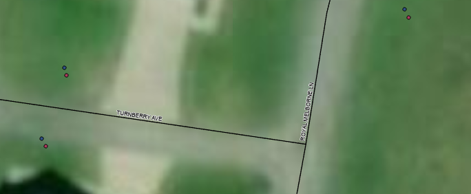
- Mark as New
- Bookmark
- Subscribe
- Mute
- Subscribe to RSS Feed
- Permalink
Are the points in the same feature class/service or different?
If they are in the same, you can select the points you want to adjust and apply a delta move using your control points to determine the adjustment values. Take a look at Moving a feature relative to its current location (delta x,y). The points are still not going to fall exactly on top of each other but you would likely be dealing with the accuracy of the instrument at that point.
If they are in different feature classes or services you could experiment with applying different transformations to the points that may be applicable to the data. See if one moves the data in closer together.
Based upon your previous reply, you could have been using a base station that was a little too far away and an incorrect correction factor was applied. As you noted, you could rerun the post-processing to see if that helps with the issue.
One additional note, you still need to determine which point set is correct. See if you can locate some imagery of the area that is higher resolution and accurately rectified or, better yet, if you have some survey grade data that can de used to cross check against.
- Mark as New
- Bookmark
- Subscribe
- Mute
- Subscribe to RSS Feed
- Permalink
Hey Lance, I discovered somehow there was points collected from my office that is hours away from where I collected the majority of my data. Could these few points being so far away from the rest throw off the accuracy of the rest of the points? It actually kinda would make sense since my office is NW from the site visit, and the points are all skewed a meter off. I am going to try to find a way to delete those random points that are showing around my office then try post-processing again.