- Home
- :
- All Communities
- :
- Products
- :
- ArcGIS Online
- :
- ArcGIS Online Questions
- :
- District Lookup Widget Issues
- Subscribe to RSS Feed
- Mark Topic as New
- Mark Topic as Read
- Float this Topic for Current User
- Bookmark
- Subscribe
- Mute
- Printer Friendly Page
District Lookup Widget Issues
- Mark as New
- Bookmark
- Subscribe
- Mute
- Subscribe to RSS Feed
- Permalink
I'm working with the School Locator ArcGIS Solutions deployment WAB. I'm trying to edit the District Lookup Widget and I'm banging my head against the wall.
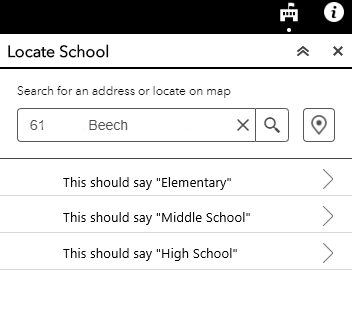
First, I have the "School District" layer set up with attendance boundaries for elementary, middle and high schools. When I geolocate an address, three menus pop up in the widget that zooms to and displays these three different boundaries. Great. The problem is, these menus are blank. How do I label them?? They are useless if people don't know to click on them.
Second, I cannot figure out how to edit the popup in the district locator widget. I have a popup defined in my schools points layer. I disabled the popup for the school district layer, yet the boilerplate popup expression from that layer remains. No matter how I configure the popups in either layer, this is what I see:
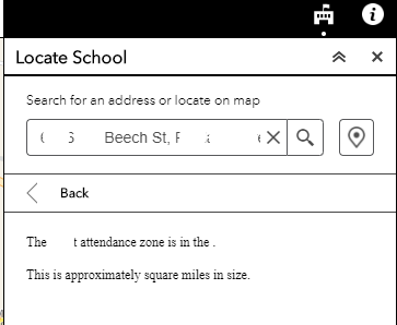
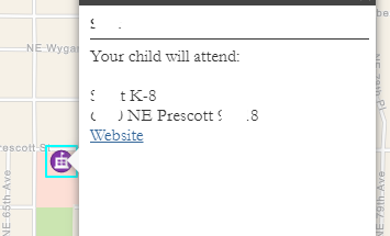
I want this to display the school name, address and website as it does in the point layer popup. (I've blurred out the particulars)
I see this on the district lookup widget ESRI page:
Note:
The widget uses the pop-up defined in the map on the Information tab. You can enable one or both layers to have pop-ups. Whatever is defined will be displayed on the Information tab.
Where is the information tab? On the web map feeding the WAB? I cannot find it.
- Mark as New
- Bookmark
- Subscribe
- Mute
- Subscribe to RSS Feed
- Permalink
The solution was to delete the district lookup app and start over.