- Home
- :
- All Communities
- :
- Products
- :
- ArcGIS Online
- :
- ArcGIS Online Questions
- :
- different number of fields when collecting using c...
- Subscribe to RSS Feed
- Mark Topic as New
- Mark Topic as Read
- Float this Topic for Current User
- Bookmark
- Subscribe
- Mute
- Printer Friendly Page
different number of fields when collecting using collector
- Mark as New
- Bookmark
- Subscribe
- Mute
- Subscribe to RSS Feed
- Permalink
Hi all,
I'm trying to develop a collector app where foresters can store their observations in the field, like for example a special tree, animal nestingplace or rare plant they encounter
My question is how I can present different (numbers of) fields to note details depending on the subject they choose.
When selecting 'tree' I want them to be able to note things like species, height, thickness, hollows or not and if yes, how many.
When selecting 'nestingplace' I want tot ask them whether it is in use or not, what animal or plant is living there.
When selecting 'plant' all they have to do is picking the name from the domain provided list.
At the moment I have a couple of coded domains set up but I'm getting stuck now.
I'm on a basic license here, does this handicap me in this project?
regards,
Bert
Solved! Go to Solution.
Accepted Solutions
- Mark as New
- Bookmark
- Subscribe
- Mute
- Subscribe to RSS Feed
- Permalink
When the user clicks the icon to begin collecting features, they will be presented with a list of the different layers:
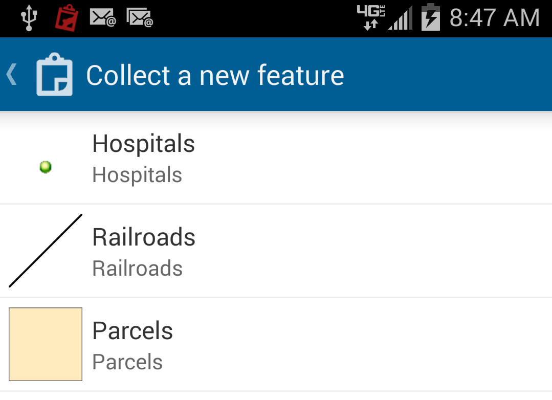
The user can select the correct layer (i.e. tree, nest, etc) and they will only be able to edit the attributes associated with this.
Correcting from my initial post, you wouldn't need to have 3 different feature services. You could just have 3 different feature classes in one service. In the above example, I have three feature classes (hospitals, railroads, and parcels) in one hosted feature service.
- Mark as New
- Bookmark
- Subscribe
- Mute
- Subscribe to RSS Feed
- Permalink
Hi Bert,
I would recommend using 3 different feature services, one for 'tree', another for 'nestingplace', and a third for 'plant'. You can then more easily associate the required fields and their domains. Out-of-the-box, ArcGIS does not offer the capability of enabling/disabling fields based on another field.
- Mark as New
- Bookmark
- Subscribe
- Mute
- Subscribe to RSS Feed
- Permalink
Hi Jake, thanks for responding,
So, this would lead me to having several feature classes, each developed for it's own purpose. Seems like a good idea! But I would like to present the users with just one list (tree, nest, plant, critter and so on, I have 8 or 9 in total) from which they are led to the correct feature class and asked to fill in the relevant fields.
How do I 'connect' (if thats the right word) from that initial list to the correct feature class.
- Mark as New
- Bookmark
- Subscribe
- Mute
- Subscribe to RSS Feed
- Permalink
When the user clicks the icon to begin collecting features, they will be presented with a list of the different layers:
The user can select the correct layer (i.e. tree, nest, etc) and they will only be able to edit the attributes associated with this.
Correcting from my initial post, you wouldn't need to have 3 different feature services. You could just have 3 different feature classes in one service. In the above example, I have three feature classes (hospitals, railroads, and parcels) in one hosted feature service.